Dajti
| Dajti | |
|---|---|
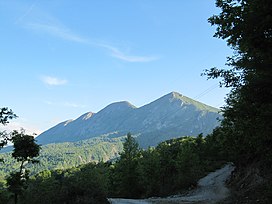 Dajt as seen from the east. | |
| Highest point | |
| Elevation | 1,613 m (5,292 ft) |
| Coordinates | 41°21′57″N 19°55′32″E / 41.36583°N 19.92556°ECoordinates: 41°21′57″N 19°55′32″E / 41.36583°N 19.92556°E |
| Geography | |
| Location | Tirana, Albania |
| Parent range | Skanderbeg Mountains |
| Geology | |
| Age of rock | Triassic |
| Mountain type | Karst[1] |
| Climbing | |
| Easiest route | SH54 |

Dajti (Albanian: Mali i Dajtit) standing at 1,613 m (5,292 ft) above sea level, is a mountain and national park on the edge of Tirana, Albania. The Dajti belongs to the Skanderbeg range. In winter, the mountain is often covered with snow, and it is a popular retreat to the local population of Tirana that rarely sees snow falls. Its slopes have forests of pines, oak and beech, while its interior contains canyons, waterfalls, caves, a lake, and an ancient castle.
Protected area[]
Dajti National Park was declared a national park in 1966, and has an expanded area of about 29,384 hectares since 2006.[2] The area is under shared jurisdiction between Albanian Agency of Protected Areas (AKZM) and Tirana Municipality Parks and Recreation Agency (APR). In 2019, the new Dajti Mt National Park tourist information centre was opened located near the TV and Radio towers along SH47 road in Fushe Dajt.[3]

The mountain can be reached through a narrow asphalted mountain road onto an area known as Fusha e Dajtit. This was the location of a summer camp but now is the site of many restaurants and radio and TV transmitters. From this small area there is an excellent view of Tirana and its plain. This is the reason this place has been named as the Balcony of Tirana.
From June 2005, hikers and visitors of the mountain can use an Austrian built gondola lift from the eastern outskirts of Tirana to Fusha e Dajtit (Plain of Dajti) at 1050 meters altitude.[4] On the summit of Mount Dajti there exist several radio and TV transmitters.
Lately, traces of prehistoric settlements and fortifications from later periods have been discovered in the area.
Environmental issues[]

A serious environmental problem on the mountain is, how to deal with garbage. This is partially caused by restaurants and hotels that leave rubbish everywhere since there are few garbage bins in the region.[citation needed]
Another major problem on the mountain is deforestation. In the summer of 2012, 10 ha of forests were burned at the Priska summit.[5] Forest fires are happening yearly while those responsible are not being convicted. Responsibilities lie with the Ministry of the Environment, Municipality of Tirana, foresters (rangers) and the people who live in the area.
Water pollution of the lake and air pollution caused by cars crossing the mountain roads are also problematic.
See also[]
| Wikimedia Commons has media related to Dajti Mountain. |
- Geography of Albania
- Mountains of Albania
- Dajti National Park
- Dajti Castle
Gallery[]

Tirana from the Big Park with Mount Dajt in the background

The peak of the Mountain
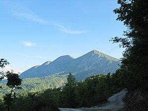
Seen from the east

Dajti Mountain seen from central Tirana

Tirana seen from Dajti


References[]
- ^ "Facing environmental problems in karst areas of developing countries: the case study of Dajti - Mali me Gropa (Albania)" (PDF). meetings.copernicus.org. p. 1.
- ^ "Archived copy" (PDF). Archived from the original (PDF) on 2016-03-04. Retrieved 2014-12-07.CS1 maint: archived copy as title (link)
- ^ "Inaugurohet qendra e re e vizitorëve në Parkun Kombëtar të Dajtit - ATSH -". 25 March 2019.
- ^ "Dajti Ekspres". Dajti Ekspres. Retrieved 21 December 2017.
- ^ http://gazeta-shqip.com/lajme/2012/08/16/zjarret-ne-dajt/
- Mountains of Albania
- Geography of Tirana County
- Tourist attractions in Tirana County
- Dajti National Park