Dauphiné Prealps
| Dauphiné Prealps | |
|---|---|
| Préalpes du Dauphiné | |
 | |
| Highest point | |
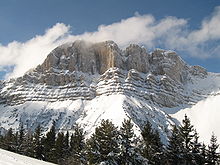
| Peak | Grande Tête de l'Obiou |
| Elevation | 2,790 m (9,150 ft)[1] |
| Coordinates | 44°46′31″N 5°50′22″E / 44.77528°N 5.83944°ECoordinates: 44°46′31″N 5°50′22″E / 44.77528°N 5.83944°E |
| Geography | |
 Dauphiné Prealps (section nr.6) within Western Alps
| |
| Country | France |
| Région | Rhône-Alpes, Provence-Alpes-Côte d'Azur |
| Rivers | Drac, Durance, Isère and Drôme |
| Parent range | Alps |
| Borders on | Provence Alps and Prealps, Dauphiné Alps and Savoy Prealps |
| Geology | |
| Orogeny | Alpine orogeny |
| Type of rock | Sedimentary rocks[2] |

The Dauphiné Prealps (Préalpes du Dauphiné in French) are a mountain range in the south-western part of the Alps. They are located in Rhône-Alpes and, marginally, in Provence-Alpes-Côte d'Azur (south-eastern France). Dauphiné Prealps are the central section of the French Prealps.
Etymology[]
The Dauphiné (pronounced [dofine]) is a historical region whose area roughly corresponded to that of the present departments of Isère, Drôme, and Hautes-Alpes.
Geography[]
Administratively the French part of the range belongs to the French departments of Isère, Drôme, Hautes-Alpes and, marginally, Alpes-de-Haute-Provence. The whole range is drained by the Rhone river.
SOIUSA classification[]
According to SOIUSA (International Standardized Mountain Subdivision of the Alps) the mountain range is an Alpine section, classified in the following way:[3]
- Main part = Western Alps
- Major sector = South Western Alps
- Section = Dauphiné Prealps
- Code = I/A-6
Borders[]
Dauphiné Prealps' borders are (anticlockwise):
- Isère (north);
- Drac, Col Bayard - which connects them with Dauphiné Alps - and Durance (east)
- Buëch, Col de Macuègne - which connects them with Provence Alps and prealps - and Toulourenc river (south);
- Rhone and Isère valleys (west).
Subdivision[]
The Dauphiné Prealps are divided into five Alpine subsections:[3]
- Dévoluy Mountains - SOIUSA code:I/A-6.I;
- Massif Céüse-Aujour - SOIUSA code:I/A-6.II;
- Massif du Vercors - SOIUSA code:I/A-6.III;
- Massif du Diois - SOIUSA code:I/A-6.IV;
- Massif des Baronnies - SOIUSA code:I/A-6.V.
Notable summits[]
Some notable summits of the range are:
| Name | metres | feet |
|---|---|---|
| Grande Tête de l'Obiou | 2,790 | 9,148 |
| 2,759 | 9,049 | |
| Pic de Bure | 2,709 | 8,885 |
| Jocou | 2,501 | 8,203 |
| Grand Veymont | 2,346 | 7,694 |
Notable passes[]
Some notable passes of the range are:
| Name | location | type | elevation (m) | elevation (ft) |
|---|---|---|---|---|
| Col de la Croix Haute | Clelles to Lus-la-Croix-Haute | road | 1,179 | 3,867 |
| Col Bayard | Gap to Grenoble | road | 1,248 | 4,093 |
| Col du Noyer | Le Noyer to Saint-Étienne-en-Dévoluy | road | 1,664 | 5,458 |
References[]
- ^ Highest summit elevation as reported on Géoportail of Institut Géographique National
- ^ Préalpes, article on Larousse encyclopedia (on line version:www.larousse.fr/encyclopedie)
- ^ a b Marazzi, Sergio (2005). Atlante Orografico delle Alpi. SOIUSA (in Italian). Priuli & Verlucca. ISBN 978-88-8068-273-8.
Maps[]
- French official cartography (Institut Géographique National - IGN); on-line version: www.geoportail.fr
| Western Alps |
| ||||||
|---|---|---|---|---|---|---|---|
| Eastern Alps |
| ||||||
- Dauphiné Prealps