Venetian Prealps
| Venetian Prealps | |
|---|---|
 Monti Lessini in winter | |
| Highest point | |
| Peak | Col Nudo |
| Elevation | 2,472 m (8,110 ft) |
| Coordinates | 46°13′44″N 12°24′05″E / 46.22889°N 12.40139°ECoordinates: 46°13′44″N 12°24′05″E / 46.22889°N 12.40139°E |
| Naming | |
| Native name | Prealpi Venete |
| Geography | |
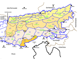 Venetian prealps (section nr.32) within Eastern Alps
| |
| Country | Italy |
| Region | Veneto, Friuli-Venezia Giulia and Trentino-Alto Adige/Südtirol |
| Province | Trento, Verona, Vicenza, Treviso, Belluno and Pordenone |
| Parent range | Alps |
| Borders on | Brescia and Garda Prealps, Dolomites, Carnic and Gailtal Alps and Venetian Plain |
| Geology | |
| Orogeny | Alpine orogeny |

The Venetian Prealps (Prealpi Venete in Italian) are a mountain range in the south-eastern part of the Alps. They are located in Triveneto, in the north-eastern part of Italy.
Geography[]
Administratively the range is divided between the Italian provinces of Trento (in the Region of Trentino Alto Adige), Verona, Vicenza, Treviso, Belluno (in the Region of Veneto) and Pordenone (in the Region of Friuli Venezia Giulia).
The Venetian Prealps are drained by the rivers Adige, Brenta, Piave and other minor rivers and streams, all of them tributaries of the Adriatic sea.
Summits[]

Northern slopes of Col Nudo
The chief summits of the Venetian prealps are:
| Name | metres | feet |
|---|---|---|
| Col Nudo | 2,472 | 8,110 |
| Cima Dodici | 2,341 | 7,680 |
| Cima Portule | 2,310 | 7,578 |
| Gruppo della Carega - Cima Carega | 2,259 | 7,411 |
| Cima Palon | 2,232 | 7,322 |
| Catena delle Tre Croci - Monte Zevola | 1,976 | 6,483 |
| Monte Grappa | 1,775 | 5,823 |
| Col Visentin | 1,764 | 5,787 |
Maps[]
- Italian official cartography (Istituto Geografico Militare - IGM); on-line version: www.pcn.minambiente.it
External links[]
| Authority control: National libraries |
|---|
Categories:
- Mountain ranges of the Alps
- Mountain ranges of Italy
- Landforms of Friuli-Venezia Giulia
- Landforms of Trentino-Alto Adige/Südtirol
- Landforms of Veneto
- Province of Pordenone
- Province of Verona
- Province of Vicenza
- Province of Treviso
- Province of Belluno
- Trentino