Deerfield (CDP), Massachusetts
Deerfield, Massachusetts | |
|---|---|
 The First Church of Deerfield | |
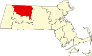
 Location in Franklin County in Massachusetts | |
| Coordinates: 42°32′40″N 72°36′20″W / 42.54444°N 72.60556°WCoordinates: 42°32′40″N 72°36′20″W / 42.54444°N 72.60556°W | |
| Country | United States |
| State | Massachusetts |
| County | Franklin |
| Town | Deerfield |
| Area | |
| • Total | 1.87 sq mi (4.84 km2) |
| • Land | 1.84 sq mi (4.76 km2) |
| • Water | 0.03 sq mi (0.08 km2) |
| Elevation | 148 ft (45 m) |
| Population (2010) | |
| • Total | 643 |
| • Density | 340/sq mi (130/km2) |
| Time zone | UTC-5 (Eastern (EST)) |
| • Summer (DST) | UTC-4 (EDT) |
| ZIP codes | 01342 |
| Area code(s) | 413 |
| FIPS code | 25-16635 |
| GNIS feature ID | 0608850 |
Deerfield is a census-designated place (CDP) in the town of Deerfield in Franklin County, Massachusetts, United States. The population was 643 at the 2010 census.[1] It corresponds roughly to the area of Historic Deerfield, a historic district comprising the original town center of Deerfield. It is the home of Deerfield Academy, a college-preparatory school.
Geography[]
According to the United States Census Bureau, the CDP has a total area of 1.87 square miles (4.84 km2), of which 1.84 square miles (4.76 km2) is land and 0.031 square miles (0.08 km2), or 1.71%, is water.[2]
References[]
- ^ "Profile of General Population and Housing Characteristics: 2010 Demographic Profile Data (DP-1): Deerfield CDP, Massachusetts". United States Census Bureau. Retrieved August 29, 2012.
- ^ "Geographic Identifiers: 2010 Demographic Profile Data (G001): Deerfield CDP, Massachusetts". United States Census Bureau. Retrieved August 29, 2012.
External links[]
Categories:
- Census-designated places in Franklin County, Massachusetts
- Springfield metropolitan area, Massachusetts
- Census-designated places in Massachusetts
