Dingelstädt
Dingelstädt | |
|---|---|
 | |
 Coat of arms | |
show Location of Dingelstädt within Eichsfeld district | |
 Dingelstädt | |
| Coordinates: 51°18′56″N 10°19′10″E / 51.31556°N 10.31944°ECoordinates: 51°18′56″N 10°19′10″E / 51.31556°N 10.31944°E | |
| Country | Germany |
| State | Thuringia |
| District | Eichsfeld |
| Government | |
| • Mayor (2019–25) | Andreas Karl Fernkorn[1] (CDU) |
| Area | |
| • Total | 59.39 km2 (22.93 sq mi) |
| Elevation | 335 m (1,099 ft) |
| Population (2020-12-31)[2] | |
| • Total | 6,834 |
| • Density | 120/km2 (300/sq mi) |
| Time zone | UTC+01:00 (CET) |
| • Summer (DST) | UTC+02:00 (CEST) |
| Postal codes | 37351 |
| Dialling codes | 036075 |
| Vehicle registration | EIC, HIG, WBS |
| Website | VG Dingelstädt |


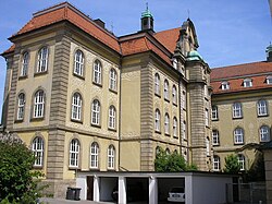
Church in Dingelstädt
Dingelstädt is a town in the district of Eichsfeld in Thuringia, Germany. It is situated on the upper course of the river Unstrut, 8 km (5 mi) south of Leinefelde-Worbis and 15 km (9 mi) northwest of Mühlhausen. The former municipalities Helmsdorf, Kefferhausen, Kreuzebra and Silberhausen were merged into Dingelstädt in January 2019.
Museums[]

All the information in the museum's exhibition is displayed in both German and English.
The Borderland Museum Eichsfeld is a history museum a few miles away from Dingelstädt which deals with the German division and the GDR. It's grounds also include a hiking trail along the former Iron Curtain.
People[]
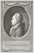
Christian Joseph Jagemann
- Christian Joseph Jagemann (1735–1804), scholar, court counselor and librarian
- Anton Thraen, (1843–1902), the German astronomer, minister and native of Holungen died in Dingelstädt
International relations[]
Dingelstädt is twinned with:
References[]
| Wikimedia Commons has media related to Dingelstädt. |
- Notes
- ^ Gewählte Bürgermeister - aktuelle Landesübersicht, Freistaat Thüringen, accessed 14 July 2021.
- ^ "Bevölkerung der Gemeinden, erfüllenden Gemeinden und Verwaltungsgemeinschaften in Thüringen Gebietsstand: 31.12.2020". Thüringer Landesamt für Statistik (in German). June 2021.
- ^ "Jarosław Official Website - Partner Cities".
 (in Polish) © 2008 Urząd Miasta Jarosław. Ul. Rynek 1, 37-500 Jarosław. Retrieved 2008-10-23.
| show Towns and municipalities in Eichsfeld (district) |
|---|
| show Authority control |
|---|
This Eichsfeld district location article is a stub. You can help Wikipedia by . |
Categories:
- Towns in Thuringia
- Eichsfeld (district)
- Province of Saxony
- Bezirk Erfurt
- Eichsfeld district geography stubs