Dinkelland
Dinkelland | |
|---|---|
Municipality | |
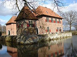 Castle in Dinkelland | |
 Flag Coat of arms | |
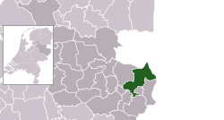 Location in Overijssel | |
| Coordinates: 52°22′N 7°0′E / 52.367°N 7.000°ECoordinates: 52°22′N 7°0′E / 52.367°N 7.000°E | |
| Country | Netherlands |
| Province | Overijssel |
| Government | |
| • Body | Municipal council |
| • Acting Mayor | (VVD) |
| Area | |
| • Total | 176.83 km2 (68.27 sq mi) |
| • Land | 175.71 km2 (67.84 sq mi) |
| • Water | 1.12 km2 (0.43 sq mi) |
| Elevation | 26 m (85 ft) |
| Population (January 2019)[4] | |
| • Total | 26,350 |
| • Density | 150/km2 (400/sq mi) |
| Time zone | UTC+1 (CET) |
| • Summer (DST) | UTC+2 (CEST) |
| Postcode | Parts of 7500 and 7600 ranges |
| Area code | 0541, 074 |
| Website | www |


Dutch Topographic map of the municipality of Dinkelland, June 2015
Dinkelland (Dutch pronunciation: [ˈdɪŋkəllɑnt] (![]() listen)) is a municipality in the eastern Netherlands. For a short time it was known as Denekamp (one of its component towns) until it was renamed in 2002.
listen)) is a municipality in the eastern Netherlands. For a short time it was known as Denekamp (one of its component towns) until it was renamed in 2002.
Population centres[]
Notable people[]
- Johan Jongkind (1819 in Lattrop – 1891) a Dutch painter and printmaker
- Theo Budde (1889 in Ootmarsum - 1959) a watchmaker, jeweler, antique dealer and poet
- Ton Schulten (born 1938 in Ootmarsum) a Dutch painter who mainly paints landscapes
- Roméo Dallaire (born 1946 in Denekamp) a Canadian humanitarian, author, statesman and retired senator and general
- Marcha (born 1956 in Lattrop) a Dutch singer and TV presenter, took part in the 1987 Eurovision Song Contest
- Han Polman (born 1963 in Ootmarsum) a Dutch politician
- Tanja Nijmeijer (born 1978 in Denekamp) a Dutch former guerrilla fighter in Colombia and English teacher
Sport[]
- Felix von Heijden (1890 in Weerselo – 1982) a footballer team bronze medallist at the 1920 Summer Olympics; & Mayor of Rosmalen 1923–1955
- Hennie Kuiper (born 1949 in Denekamp) a former professional road racing cyclist, gold medallist at the 1972 Summer Olympics
- Jos Lansink (born 1961 in Weerselo) an equestrian, team gold medallist at the 1992 Summer Olympics
- Marieke Westerhof (born 1974 in Denekamp) a retired rower, team silver medallist at the 2000 Summer Olympics
- Elles Leferink (born 1976 in Weerselo) a volleyball player, competed at the 1996 Summer Olympics
References[]
- ^ "Ineke Bakker (acting mayor)" (in Dutch). Gemeente Dinkelland. Retrieved 27 March 2014.
- ^ "Kerncijfers wijken en buurten 2020" [Key figures for neighbourhoods 2020]. StatLine (in Dutch). CBS. 24 July 2020. Retrieved 19 September 2020.
- ^ "Postcodetool for 7591MA". Actueel Hoogtebestand Nederland (in Dutch). Het Waterschapshuis. Retrieved 27 March 2014.
- ^ "Bevolkingsontwikkeling; regio per maand" [Population growth; regions per month]. CBS Statline (in Dutch). CBS. 1 January 2019. Retrieved 1 January 2019.
External links[]
| Wikivoyage has a travel guide for Dinkelland. |
 Media related to Dinkelland at Wikimedia Commons
- Official website (in Dutch)
| show Places adjacent to Dinkelland |
|---|
| show Overijssel province |
|---|

This Overijssel location article is a stub. You can help Wikipedia by . |
Categories:
- Dinkelland
- Populated places in Overijssel
- Municipalities of Overijssel
- Overijssel geography stubs