Dippach
Dippach
Dippech | |
|---|---|
Commune | |
 Dippach-Gare | |
 Coat of arms | |
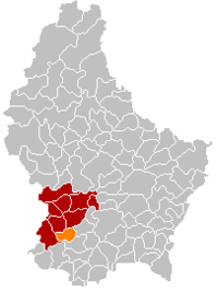 Map of Luxembourg with Dippach highlighted in orange, and the canton in dark red | |
| Coordinates: 49°35′15″N 5°59′00″E / 49.5875°N 5.9833°ECoordinates: 49°35′15″N 5°59′00″E / 49.5875°N 5.9833°E | |
| Country | |
| Canton | Capellen |
| Area | |
| • Total | 17.42 km2 (6.73 sq mi) |
| Area rank | 66th of 102 |
| Highest elevation | 352 m (1,155 ft) |
| • Rank | 84th of 102 |
| Lowest elevation | 277 m (909 ft) |
| • Rank | 79th of 102 |
| Population (2018) | |
| • Total | 4,210 |
| • Rank | 38th of 102 |
| • Density | 240/km2 (630/sq mi) |
| • Density rank | 32nd of 102 |
| Time zone | UTC+1 (CET) |
| • Summer (DST) | UTC+2 (CEST) |
| LU0000101 | |
| Website | dippach.lu |

Dippach (Luxembourgish: Dippech [ˈdipəɕ]) is a commune and small town in south-western Luxembourg. It is part of the canton of Capellen, which is part of the district of Luxembourg. The commune's administrative centre is Schouweiler. The River Mess, a tributary of the Alzette, rises here.
As of 2005, the town of Dippach, which lies in the north-east of the commune, has a population of 790. Other villages within the commune include Bettange-sur-Mess, Schouweiler, and Sprinkange.
Twin towns — sister cities[]
Dippach is twinned with:[1]
 Landiras, France
Aerial views[]
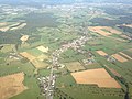
Aerial view of the localities of Dippach (Dippech)...

... and of Bettange-sur-Mess (Betten op der Mess) and Dippach-Gare (Dippech-Gare).


References[]
- ^ "Présentation". dippach.lu (in French). Dippach. Retrieved 2019-09-05.
External links[]
 Media related to Dippach (Luxembourg) at Wikimedia Commons
| show Places adjacent to Dippach |
|---|

| Authority control |
|---|
This article related to the geography of Capellen canton is a stub. You can help Wikipedia by . |
Categories:
- Dippach
- Communes in Capellen (canton)
- Towns in Luxembourg
- Luxembourg geography stubs