Sanem
Sanem
Suessem | |
|---|---|
Commune | |
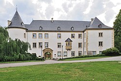 The castle | |
 Coat of arms | |
 Map of Luxembourg with Sanem highlighted in orange, and the canton in dark red | |
| Coordinates: 49°32′50″N 5°55′40″E / 49.5472°N 5.9278°ECoordinates: 49°32′50″N 5°55′40″E / 49.5472°N 5.9278°E | |
| Country | |
| Canton | Esch-sur-Alzette |
| Area | |
| • Total | 24.42 km2 (9.43 sq mi) |
| Area rank | 36th of 102 |
| Highest elevation | 422 m (1,385 ft) |
| • Rank | 34th of 102 |
| Lowest elevation | 277 m (909 ft) |
| • Rank | 79th of 102 |
| Population (2018) | |
| • Total | 16,780 |
| • Rank | 6th of 102 |
| • Density | 690/km2 (1,800/sq mi) |
| • Density rank | 11th of 102 |
| Time zone | UTC+1 (CET) |
| • Summer (DST) | UTC+2 (CEST) |
| LU0000213 | |
| Website | sanem.lu |

Sanem (Luxembourgish: Suessem [ˈzuəsəm]; German: Sassenheim) is a commune and town in south-western Luxembourg. It is part of the canton of Esch-sur-Alzette. The administrative centre and largest town is Belvaux.
As of 2005, the town of Sanem, which lies in the north of the commune, has a population of 2,397. Other towns within the commune include Belvaux, Ehlerange, and Soleuvre.
Sanem Castle[]
Sanem Castle has a history dating back to the 13th century. Today's building was completed in 1557 after the medieval castle had been partly destroyed. The castle still maintains much of its original character.[1]
Twin towns — sister cities[]
Sanem is twinned with:[2]
 Chauffailles, France
See also[]
References[]
- ^ Philippe Farcy, "Sanem, un palais enfantin", Vie de Château (461), La libre.be. (in French) Retrieved 30 March 2011.
- ^ "Espace muséologique". suessem.lu (in French). Sanem. Retrieved 2019-09-04.
External links[]
 Media related to Sanem at Wikimedia Commons
- Commune of Sanem official website
| show Places adjacent to Sanem |
|---|

| Authority control |
|---|
This article related to the geography of Esch-sur-Alzette canton is a stub. You can help Wikipedia by . |
Categories:
- Sanem
- Communes in Esch-sur-Alzette (canton)
- Towns in Luxembourg
- Luxembourg geography stubs