Frisange
This article needs additional citations for verification. (January 2021) |
Frisange
Fréiseng | |
|---|---|
Commune | |
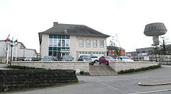 Town hall | |
 Coat of arms | |
 Map of Luxembourg with Frisange highlighted in orange, and the canton in dark red | |
| Coordinates: 49°30′54″N 6°11′30″E / 49.515°N 6.19167°ECoordinates: 49°30′54″N 6°11′30″E / 49.515°N 6.19167°E | |
| Country | |
| Canton | Esch-sur-Alzette |
| Area | |
| • Total | 18.43 km2 (7.12 sq mi) |
| Area rank | 63rd of 102 |
| Highest elevation | 293 m (961 ft) |
| • Rank | 100th of 102 |
| Lowest elevation | 224 m (735 ft) |
| • Rank | 37th of 102 |
| Population (2018) | |
| • Total | 4,612 |
| • Rank | 33rd of 102 |
| • Density | 250/km2 (650/sq mi) |
| • Density rank | 30th of 102 |
| Time zone | UTC+1 (CET) |
| • Summer (DST) | UTC+2 (CEST) |
| LU0000205 | |
| Website | frisange.lu |

Frisange (Luxembourgish: Fréiseng, German: Frisingen) is a commune and town in southern Luxembourg. It is part of the canton of Esch-sur-Alzette.
As of 2005, the town of Frisange, which lies in the north of the commune, has a population of 1,302. Other towns within the commune include Aspelt and Hellange.
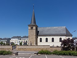
Frisange, church: l'église_Saint-Martin
Twin towns — sister cities[]
Frisange is twinned with:[1]
References[]
- ^ "Jumelage Saint-Julien de Coppel". frisange.lu (in French). Frisange. Retrieved 2019-09-05.
External links[]
 Media related to Frisange at Wikimedia Commons
| show Places adjacent to Frisange |
|---|

| show Authority control |
|---|
This article related to the geography of Esch-sur-Alzette canton is a stub. You can help Wikipedia by . |
Categories:
- Frisange
- Communes in Esch-sur-Alzette (canton)
- Towns in Luxembourg
- Luxembourg geography stubs