District Council of Streaky Bay
| District Council of Streaky Bay South Australia | |||||||||||||||
|---|---|---|---|---|---|---|---|---|---|---|---|---|---|---|---|
 The District Council office | |||||||||||||||
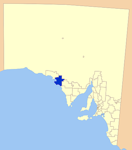
 Location of the District Council in blue | |||||||||||||||
| Population | 2,074 (2016 census)[1] | ||||||||||||||
| • Density | 0.33280/km2 (0.86194/sq mi) | ||||||||||||||
| Established | 1887 | ||||||||||||||
| Area | 6,232 km2 (2,406.2 sq mi) | ||||||||||||||
| Mayor | Travis Barber [2] | ||||||||||||||
| Council seat | Streaky Bay | ||||||||||||||
| Region | Eyre Western[3] | ||||||||||||||
| State electorate(s) | Flinders | ||||||||||||||
| Federal Division(s) | Grey | ||||||||||||||
 | |||||||||||||||
| Website | District Council of Streaky Bay | ||||||||||||||
| |||||||||||||||
The District Council of Streaky Bay is a local government area in South Australia located on the Eyre Peninsula. Streaky Bay is the main population centre of about 1200 people serving an agricultural district based on farming wheat and other cereal crops, sheep, supplemented by fishing and tourism industries. The district covers an area of 6,251.1 square kilometres with a population of 2,074 people in 2016, according to the Australian Bureau of Statistics.[1] Mayor of Streaky Bay is Travis Barber.
History[]
The council was established by the District Councils Act 1887 on 5 January 1888. The bounds were defined in the act as "All that portion of the County of Robinson not included in the district of Elliston."[4] This meant that the Hundred of Downer, Hundred of Wallis, a large part of Hundred of Wright south of Venus Bay, and an unincorporated area approximately 100 square miles between the three (proposed to be Hundred of McBeath but never gazetted) within Robinson county were excluded from Streaky Bay council and proclaimed as part of Elliston council instead.
It was, until the creation of the neighbouring District Council of Murat Bay (now Ceduna) in 1925, the farthest outpost of local government in South Australia. In the same year, the District Council of Wudinna was established to the east, annexing the hundreds of Condada, Moorkitabie, Carina, Addison and Travers (about 549 sq mi (1,420 km2)) from Streaky Bay council to form the north western flank of the new council.
While the town of Streaky Bay was named Flinders until 1940, the municipality has been titled Streaky Bay since its inception. In 1936, it was the largest local government area in South Australia, covering 6,532.6 square kilometres (1,614,240 acres).[5][6]
Localities[]
The district's focal point is the town of Streaky Bay; it also includes the localities of Baird Bay, , Calca, , , , Cungena, Eba Anchorage, Haslam, , , Maryvale, Mortana, , , Perlubie, , Poochera, Sceale Bay, , , Wirrulla, , , and Yantanabie, and parts of , , , and Pureba.[7]
Elected members[]
| Ward | Councillor | Notes | |
|---|---|---|---|
| Eyre [2] | Graham Gunn | ||
| Trudy McGowan | |||
| Philip Wheaton | Deputy Mayor | ||
| Flinders [2] | Travis Barber | Mayor | |
| Peter Hackett | |||
| Lauren Karp | |||
| Clifford J Pudney | |||
| Neville Trezona | |||
Chairmen and mayors of Streaky Bay[]
- Peter Calder Anderson (1927-1938) [8]
- William John Williams (1938-1949) [8]
- Gregory John Cash (1949-1954) [8]
- Arthur Donald Andrew Dodgson (1954-1964) [8]
- Frederick Allen Bellinger (1964-1971) [8]
- Alec Malcolm Baldock (1971-1977) [8]
- Peter John Dodgson (1977-1984) [8]
- Thomas Aiden McCormack (1985-1987)
- John Wharff (1987-1993 and 1997-2003)
- Keith Johnson (1993-1997)
- Ian Gunn (2003-2010)
- Robert Stephens (2010-2014)
- Sherron McKenzie (2014-2016)
- Travis Barber (2016-?)
See also[]
- Murphys Haystacks
- List of parks and gardens in rural South Australia
References[]
- ^ Jump up to: a b Australian Bureau of Statistics (27 June 2017). "Streaky Bay (DC)". 2016 Census QuickStats. Retrieved 10 April 2018.

- ^ Jump up to: a b c "Elected Members". District Council of Streaky Bay. Retrieved 22 June 2017.
- ^ "Eyre Western SA Government region" (PDF). The Government of South Australia. Retrieved 10 October 2014.
- ^ "The District Councils Act 1887 No. 419". Government of South Australia. p. 51. Retrieved 13 October 2017 – via Flinders University.
- ^ Hosking, P. (1936). The Official civic record of South Australia : centenary year, 1936. Adelaide: Universal Publicity Company. pp. 872–874.
- ^ Streaky Bay And Districts (23 March 2006). "History of Streaky Bay". Archived from the original on 29 August 2007. Retrieved 26 March 2007.
- ^ "Location SA Map Viewer". Government of South Australia. Retrieved 14 February 2016.
- ^ Jump up to: a b c d e f g Matthews, Penny (1986), South Australia, the civic record, 1836-1986, Wakefield Press, pp. 568–569, ISBN 978-0-949268-82-2
External links[]
| Wikimedia Commons has media related to District Council of Streaky Bay. |
- Populated places established in 1887
- 1887 establishments in Australia
- Local government areas of South Australia
- Eyre Peninsula
