Division No. 9, Newfoundland and Labrador
Division No. 9 | |
|---|---|
 | |
| Coordinates: 50°20′00″N 57°31′54″W / 50.33333°N 57.53167°WCoordinates: 50°20′00″N 57°31′54″W / 50.33333°N 57.53167°W | |
| Country | Canada |
| Province | Newfoundland and Labrador |
| Area | |
| • Total | 13,527.12 km2 (5,222.85 sq mi) |
| As of 2016 | |
| Population (2016)[1] | |
| • Total | 15,607 |
| • Density | 1.2/km2 (3.0/sq mi) |

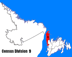
Census Division No. 9 is composed of the area of the province of Newfoundland and Labrador called the Northern Peninsula. It has a land area of 13,527.12 km² (5,222.85 sq mi) and had a population of 15,607 at the 2016 census.[1] The largest community is the town of St. Anthony, near its northern tip, on the Atlantic Ocean coast.
It includes most of the Great Northern Peninsula, along with Gros Morne National Park.
| Year | Pop. | ±% |
|---|---|---|
| 2001 | 20,091 | — |
| 2006 | 18,084 | −10.0% |
| 2011 | 16,786 | −7.2% |
| 2016 | 15,607 | −7.0% |
| [2][1][3] | ||
Towns[]
| Name | 2016 Census of Population[4] | ||||
|---|---|---|---|---|---|
| Population (2016) | Population (2011) | Change | Land area (km²) | Population density | |
| Anchor Point | 314 | 326 | -3.7% | 2.41 | 130.2/km2 |
| Bellburns | 53 | 62 | -14.5% | 7.39 | 7.2/km2 |
| Bird Cove | 179 | 182 | -1.6% | 9.39 | 19.1/km2 |
| Conche | 170 | 181 | -6.1% | 9.25 | 18.4/km2 |
| Cook's Harbour | 123 | 176 | -30.1% | 1.95 | 63.1/km2 |
| Cow Head | 418 | 475 | -9.9% | 17.84 | 24.0/km2 |
| Daniel's Harbour | 253 | 265 | -4.5% | 8.19 | 30.9/km2 |
| Englee | 527 | 583 | -9.6% | 28.8 | 18.3/km2 |
| Flower's Cove | 270 | 308 | -12.3% | 7.64 | 35.3/km2 |
| Glenburnie-Birchy Head-Shoal Brook | 224 | 258 | -13.2% | 6.57 | 34.1/km2 |
| Goose Cove East | 174 | 211 | -17.5% | 2.69 | 64.7/km2 |
| Hawke's Bay | 315 | 338 | -6.8% | 46.55 | 6.8/km2 |
| Main Brook | 243 | 265 | -8.3% | 28.51 | 8.5/km2 |
| Norris Point | 670 | 685 | -2.2% | 4.91 | 136.5/km2 |
| Parson's Pond | 345 | 383 | -9.9% | 12.63 | 27.3/km2 |
| Port au Choix | 789 | 839 | -6.0% | 35.61 | 22.2/km2 |
| Port Saunders | 647 | 697 | -3.3% | 38.81 | 17.4/km2 |
| Raleigh | 177 | 201 | -11.9% | 11.12 | 15.9/km2 |
| River of Ponds | 215 | 228 | -5.7% | 4.69 | 45.8/km2 |
| Rocky Harbour | 947 | 979 | -3.3% | 12.08 | 78.4/km2 |
| Roddickton-Bide Arm | 999 | 1057 | -5.5% | 47.85 | 20.9/km2 |
| Sally's Cove | 20 | 27 | -25.9% | 4.54 | 4.4/km2 |
| St. Anthony | 2258 | 2418 | -6.6% | 37.02 | 61.0/km2 |
| St. Lunaire-Griquet | 604 | 661 | -8.6% | 16.68 | 36.2/km2 |
| St. Pauls | 238 | 258 | -7.8% | 5.35 | 44.5/km2 |
| Trout River | 552 | 576 | -4.2% | 5.91 | 93.4/km2 |
| Woody Point | 282 | 281 | +0.4% | 2.91 | 96.9/km2 |
Unorganized subdivisions[]
- (Includes: Wiltondale, Lomond, Green Point)
- Subdivision C (Includes: Plum Point, St. Barbe, Savage Cove)
- Subdivision D (Includes: Ship Cove, Straitsview, Great Brehat)
- Subdivision F (Includes: Croque, Williamsport, Grandois)
- Subdivision G (Includes: Eddies Cove West, Barr'd Harbour)
- Subdivision H (Includes: Three Mile Rock, Portland Creek, Shallow Bay)
References[]
- ^ a b c d "Census Profile, 2016 Census Division No. 9, Census division [Census division], Newfoundland and Labrador". Statistics Canada. Retrieved October 13, 2019.
- ^ "2006 Community Profiles: Division No. 9". Statistics Canada. Retrieved October 13, 2019.
- ^ "Census Profile - Division No. 9, Census division". Statistics Canada. Retrieved 2 March 2012.
- ^ "Census Profile, 2016 Census - Newfoundland and Labrador". Statistics Canada. February 8, 2017. Retrieved 2020-06-03.
Sources[]
- "(Code 1009) Census Profile". 2011 census. Statistics Canada. 2012.
Places adjacent to Division No. 9, Newfoundland and Labrador | ||||||||||||||||
|---|---|---|---|---|---|---|---|---|---|---|---|---|---|---|---|---|
| ||||||||||||||||
| Towns |
|  |
|---|---|---|
| Unorganized subdivisions |
| |
| Designated places |
| |
| Cities | |
|---|---|
| Other communities |
|
| Census divisions | |
| |
Categories:
- Census divisions of Newfoundland and Labrador