Doi Saket District
This article does not cite any sources. (August 2018) |
Doi Saket
ดอยสะเก็ด | |
|---|---|
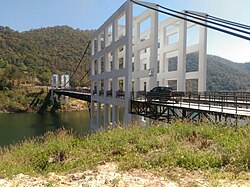
 A suspension bridge over the | |
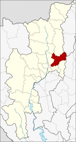
 District location in Chiang Mai Province | |
| Coordinates: 18°52′13″N 99°8′12″E / 18.87028°N 99.13667°ECoordinates: 18°52′13″N 99°8′12″E / 18.87028°N 99.13667°E | |
| Country | Thailand |
| Province | Chiang Mai |
| Seat | Doi Saket |
| Tambon | 14 |
| Muban | 110 |
| District established | 1902 |
| Area | |
| • Total | 671.3 km2 (259.2 sq mi) |
| Population (2005) | |
| • Total | 64,116 |
| • Density | 95.5/km2 (247/sq mi) |
| Time zone | UTC+7 (ICT) |
| Postal code | 50220 |
| Geocode | 5005 |


Doi Saket (Thai: ดอยสะเก็ด, pronounced [dɔ̄ːj sā.kèt]; Northern Thai: ![]() ) is a district (amphoe) in the eastern part of Chiang Mai Province in northern Thailand. The district is predominantly a rural farming area, containing a mixture of rice fields on the valley floor to orchard and other farming on the hillsides. The village is known for its murals inside Wat Doi Saket.
) is a district (amphoe) in the eastern part of Chiang Mai Province in northern Thailand. The district is predominantly a rural farming area, containing a mixture of rice fields on the valley floor to orchard and other farming on the hillsides. The village is known for its murals inside Wat Doi Saket.
History[]
The district was established in 1902.
Geography[]
Neighboring districts are (from the south clockwise) Mae On, San Kamphaeng, , Mae Taeng, Phrao of Chiang Mai Province, Wiang Pa Pao of Chiang Rai Province and Mueang Pan of Lampang Province.
The district is named after 1,816 m high Doi Saket (ดอยสะเก็ด), a mountain of the Khun Tan Range on the east side of the district.
Administration[]
The district is divided into 14 sub-districts (tambons), which are further subdivided into 110 villages (mubans). Doi Saket is a township (thesaban tambon), which covers parts of tambon Choeng Doi and Luang Nuea. There are a further 13 tambon administrative organizations (TAO).
| No. | Name | Thai name | Villages | Pop. | |
|---|---|---|---|---|---|
| 1. | Choeng Doi | เชิงดอย | 13 | 10,750 | |
| 2. | San Pu Loei | สันปูเลย | 14 | 9,137 | |
| 3. | Luang Nuea | ลวงเหนือ | 10 | 6,330 | |
| 4. | Pa Pong | ป่าป้อง | 7 | 3,549 | |
| 5. | Sa-nga Ban | สง่าบ้าน | 5 | 2,225 | |
| 6. | Pa Lan | ป่าลาน | 6 | 1,993 | |
| 7. | Talat Khwan | ตลาดขวัญ | 6 | 3,418 | |
| 8. | Samran Rat | สำราญราษฎร์ | 8 | 3,366 | |
| 9. | Mae Khue | แม่คือ | 6 | 4,797 | |
| 10. | Talat Yai | ตลาดใหญ่ | 5 | 3,760 | |
| 11. | Mae Hoi Ngoen | แม่ฮ้อยเงิน | 6 | 3,848 | |
| 12. | Mae Pong | แม่โป่ง | 10 | 5,589 | |
| 13. | Pa Miang | ป่าเมี่ยง | 6 | 3,638 | |
| 14. | Thep Sadet | เทพเสด็จ | 8 | 1,716 |
External links[]
- Amphoe of Chiang Mai Province
- Chiang Mai geography stubs
