Dolany nad Vltavou
Dolany nad Vltavou | |
|---|---|
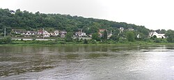 Look over the Vltava | |
 Flag 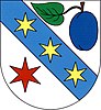 Coat of arms | |
 Dolany nad Vltavou Location in the Czech Republic | |
| Coordinates: 50°13′20″N 14°20′59″E / 50.22222°N 14.34972°ECoordinates: 50°13′20″N 14°20′59″E / 50.22222°N 14.34972°E | |
| Country | |
| Region | Central Bohemian |
| District | Mělník |
| First mentioned | 1318 |
| Area | |
| • Total | 5.50 km2 (2.12 sq mi) |
| Elevation | 192 m (630 ft) |
| Population (2021-01-01)[1] | |
| • Total | 935 |
| • Density | 170/km2 (440/sq mi) |
| Time zone | UTC+1 (CET) |
| • Summer (DST) | UTC+2 (CEST) |
| Postal code | 278 01 |
| Website | www |

Dolany nad Vltavou (until 2016 Dolany) is a municipality and village in Mělník District in the Central Bohemian Region of the Czech Republic. It has about 900 inhabitants.
Administrative parts[]
The village of Debrno is an administrative part of Dolany nad Vltavou.
Geography[]
Dolany nad Vltavou lies on the left bank of the river Vltava, approximately 3 km southeast of Kralupy nad Vltavou. The municipality is situated along the shore in the place, where the rocky valley of the Vltava ends and begins a plain typical for the confluence of the rivers Vltava and Elbe. The highest peak is Nehošť (268 m).
References[]
| Authority control: National libraries |
|---|
Categories:
- Populated places in Mělník District
- Villages in Mělník District
- Mělník geography stubs