Don Pedro Island State Park
| Don Pedro Island State Recreation Area | |
|---|---|
IUCN category IV (habitat/species management area) | |
 | |
 | |
| Location | Charlotte County, Florida, United States |
| Nearest city | Boca Grande, Florida |
| Coordinates | 26°52′16″N 82°19′16″W / 26.87111°N 82.32111°WCoordinates: 26°52′16″N 82°19′16″W / 26.87111°N 82.32111°W |
| Established | 1985 |
| Governing body | Florida Department of Environmental Protection |

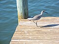
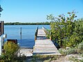
Don Pedro Island State Recreation Area is a state park in the U.S. state of Florida. It is located on a stretch of Don Pedro Island, a 129-acre (0.52 km2) barrier island lying across the Intracoastal Waterway from Placida in Charlotte County, between and Little Gasparilla Island. The park has mangrove forests, dunes and white beaches. Activities include swimming, sunbathing, shelling and viewing nature. Among the wildlife of the park are loggerhead turtles. Amenities include beaches, docks, and picnic areas as well as guided nature talks and walks. The park is only accessible by boat and is open from 8:00 am till sundown year round. The easiest way to get there is Palm Island Transit. The location of the Palm Island Transit is 2000 Panama Boulevard, Englewood, Florida.
Gallery[]
References[]
External links[]
![]() Media related to Don Pedro Island State Park at Wikimedia Commons
Media related to Don Pedro Island State Park at Wikimedia Commons
- Don Pedro Island State Park at Florida State Parks
- Don Pedro Island State Recreation Area at Absolutely Florida
- Don Pedro Island State Recreation Area at Wildernet
This Florida State Park related article is a stub. You can help Wikipedia by . |
This Charlotte County, Florida location article is a stub. You can help Wikipedia by . |
- IUCN Category IV
- State parks of Florida
- Parks in Charlotte County, Florida
- Beaches of Florida
- Protected areas established in 1985
- 1985 establishments in Florida
- Beaches of Charlotte County, Florida
- Florida state park stubs
- Southwest Florida geography stubs