Dora, Alabama
Dora | |
|---|---|
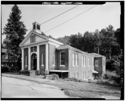 Old Methodist Church, taken as part of the Historic American Buildings Survey | |
 Location of Dora in Walker County, Alabama. | |
| Coordinates: 33°43′45″N 87°5′25″W / 33.72917°N 87.09028°WCoordinates: 33°43′45″N 87°5′25″W / 33.72917°N 87.09028°W | |
| Country | United States |
| State | Alabama |
| County | Walker |
| Government | |
| • Mayor | Randy Stephens |
| Area | |
| • Total | 7.92 sq mi (20.51 km2) |
| • Land | 7.91 sq mi (20.49 km2) |
| • Water | 0.01 sq mi (0.03 km2) |
| Elevation | 394 ft (120 m) |
| Population (2010) | |
| • Total | 2,025 |
| • Estimate (2019)[1] | 1,905 |
| • Density | 240.86/sq mi (92.99/km2) |
| Time zone | UTC-6 (Central (CST)) |
| • Summer (DST) | UTC-5 (CDT) |
| FIPS code | 01-21136 |
| GNIS feature ID | 0155055 |
| Website | www.cityofdora.com |

Dora is a city in Walker County, Alabama, United States. The first settlers in the area were James. M. Davis and Ezekiel Morgan in the 1830s.[3] It initially incorporated as the town of Horse Creek on February 18, 1897, but changed its name to Dora in 1906.[3] At the 2010 census the population was 2,025, down from 2,413 in 2000.
Geography[]
According to the U.S. Census Bureau, the city has a total area of 7.5 square miles (19 km2), all land.
Demographics[]
| Historical population | |||
|---|---|---|---|
| Census | Pop. | %± | |
| 1900 | 385 | — | |
| 1910 | 916 | 137.9% | |
| 1920 | 1,117 | 21.9% | |
| 1930 | 1,143 | 2.3% | |
| 1940 | 1,032 | −9.7% | |
| 1950 | 984 | −4.7% | |
| 1960 | 1,776 | 80.5% | |
| 1970 | 1,862 | 4.8% | |
| 1980 | 2,327 | 25.0% | |
| 1990 | 2,214 | −4.9% | |
| 2000 | 2,413 | 9.0% | |
| 2010 | 2,025 | −16.1% | |
| 2019 (est.) | 1,905 | [1] | −5.9% |
| U.S. Decennial Census[4] 2013 Estimate[5] | |||
At the 2000 census there were 2,413 people, 984 households, and 711 families living in the city. The population density was 319.9 people per square mile (123.6/km2). There were 1,080 housing units at an average density of 143.2 per square mile (55.3/km2). The racial makeup of the city was 80.61% White, 16.66% Black or African American, 0.29% Native American, 0.21% Asian, 0.08% Pacific Islander, 0.08% from other races, and 2.07% from two or more races. 0.12% of the population were Hispanic or Latino of any race.[6] Of the 984 households 32.9% had children under the age of 18 living with them, 50.3% were married couples living together, 18.8% had a female householder with no husband present, and 27.7% were non-families. 25.3% of households were one person and 11.8% were one person aged 65 or older. The average household size was 2.45 and the average family size was 2.93.
The age distribution was 26.2% under the age of 18, 8.8% from 18 to 24, 26.5% from 25 to 44, 25.1% from 45 to 64, and 13.5% 65 or older. The median age was 36 years. For every 100 females, there were 81.8 males. For every 100 females age 18 and over, there were 80.3 males.
The median household income was $21,458 and the median family income was $29,000. Males had a median income of $28,942 versus $19,886 for females. The per capita income for the city was $14,560. About 23.1% of families and 27.9% of the population were below the poverty line, including 39.0% of those under age 18 and 23.5% of those age 65 or over.
2010 census[]
At the 2010 census there were 2,025 people, 820 households, and 575 families living in the city. The population density was 270 people per square mile (103.8/km2). There were 959 housing units at an average density of 127.9 per square mile (49.2/km2). The racial makeup of the city was 85.6% White, 12.2% Black or African American, 0.3% Native American, 0% Asian, 0.1% Pacific Islander, 0.3% from other races, and 1.3% from two or more races. 0.7% of the population were Hispanic or Latino of any race.[7] Of the 820 households 27.0% had children under the age of 18 living with them, 48.8% were married couples living together, 17.1% had a female householder with no husband present, and 29.9% were non-families. 27.2% of households were one person and 11.3% were one person aged 65 or older. The average household size was 2.47 and the average family size was 2.98.
The age distribution was 23.6% under the age of 18, 8.4% from 18 to 24, 26.3% from 25 to 44, 25.5% from 45 to 64, and 16.2% 65 or older. The median age was 39.2 years. For every 100 females, there were 91.4 males. For every 100 females age 18 and over, there were 97.6 males.
The median household income was $26,596 and the median family income was $37,946. Males had a median income of $35,586 versus $22,652 for females. The per capita income for the city was $18,902. About 29.0% of families and 25.0% of the population were below the poverty line, including 42.3% of those under age 18 and 3.1% of those age 65 or over.
The city is home to a combined elementary/junior high school and a high school, Dora High School.[3] The mascot for the high school is the bulldog and it is a member of the Walker County Board of Education.
Notable people[]
- Ivy Andrews, former Major League Baseball pitcher
- Terry Fell, country music singer
- Sybil Gibson, painter
- Chavis Williams, former linebacker for the Baltimore Ravens
- Jimi Westbrook, Musician in the band Little Big Town
References[]
- ^ Jump up to: a b "Population and Housing Unit Estimates". United States Census Bureau. May 24, 2020. Retrieved May 27, 2020.
- ^ "2019 U.S. Gazetteer Files". United States Census Bureau. Retrieved June 29, 2020.
- ^ Jump up to: a b c "Encyclopedia of Alabama". Alabama Humanities Foundation. Retrieved 1 September 2014.
- ^ "U.S. Decennial Census". Census.gov. Retrieved June 6, 2013.
- ^ "Annual Estimates of the Resident Population: April 1, 2010 to July 1, 2013". Archived from the original on May 22, 2014. Retrieved June 3, 2014.
- ^ "U.S. Census website". United States Census Bureau. Retrieved 2008-01-31.
- ^ "U.S. Census website". United States Census Bureau. Retrieved 2015-08-14.
| show Municipalities and communities of Walker County, Alabama, United States |
|---|

| show Authority control |
|---|
- Cities in Alabama
- Cities in Walker County, Alabama
- Birmingham metropolitan area, Alabama