Downtown Oakland

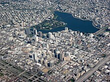


Downtown Oakland is the central business district of Oakland, California, United States; roughly bounded by both the Oakland Estuary and Interstate 880 on the southwest, Interstate 980 on the northwest, Grand Avenue on the northeast, and Lake Merritt on the east.
The Downtown area is sometimes expanded to refer to the industrial and residential Jack London Square and Jack London warehouse district areas, the Lakeside Apartments District, which are a largely residential neighborhood on the west side of Lake Merritt, the Civic Center district, Chinatown, and the south end of Oakland's Broadway Auto Row, an area along Broadway which has historically been used by car dealers and other automotive service businesses. While many consider these areas outside of downtown proper, they are generally considered more geographically proximate to Downtown Oakland than to East Oakland, North Oakland or to West Oakland and are thus sometimes associated with Downtown Oakland.
Culture[]
Black Cowboy Parade[]
Downtown Oakland hosts the only celebration of its kind in the nation in memory of the black cowboys who helped settle the American West. The annual parade typically begins on an early October weekend at DeFremery Park in West Oakland en route to Frank H. Ogawa Plaza where judging booths are set up. After an awards ceremony, the parade returns to DeFremery Park for a celebration.

Land use and points of interest[]
Downtown Oakland is home to apartment and condominium dwellers, numerous retail businesses, tall modern office buildings, shorter mixed-use historic buildings, the hubs of AC Transit and BART, which has three underground stations, the city's official Entertainment District which includes the historic Paramount and Fox Theatres, nightclubs, and restaurants, the headquarters of Clorox, City Center, a portion of Old Oakland, and a portion of Chinatown.
Downtown includes a portion of the oldest part of the city. The area from the Oakland Estuary inland to 14th Street between West Street and the Lake Merritt Channel was the original site of Oakland, and there are several 19th century houses scattered around the edges of downtown and in Chinatown.[1] The Oakland Museum is located on Oak Street near the southeastern edge of Downtown.
Education[]
Higher education[]
Laney College, with more than 12,000 students, is located on Fallon Street near the Lake Merritt BART station. Other educational institutions include Lincoln University, a small business school catering mainly to international students, and a downtown office of Cal State East Bay. Oaksterdam University, a business college which prepares students for medical cannabis work, is located on 15th Street in an area referred to as "Oaksterdam".[2][3]
The original campus of UC Berkeley was located between Franklin, Harrison, 12th and 14th streets;[1] and the University of California system is currently headquartered in Downtown.
Public primary and secondary education[]
Lincoln Elementary School, one of the few public elementary schools in the downtown of a major US city[citation needed], is on the edge of downtown, near the center of Chinatown. The Oakland School for the Arts, a charter school, is building a new facility surrounding the Fox Oakland Theatre in Oakland's Uptown Oakland.
Transportation[]
Motor vehicle limitations[]
City Hall Plaza is a city park and a "pedestrian plaza" which includes what was once the terminus of San Pablo Avenue where it met Broadway at 14th Street. It also includes 15th Street, which once ran through what is now "Kahn's Alley," past 250 Frank H. Ogawa Plaza building, across Clay Street, through what is now a glass windowed lobby of the California State office building, connecting with Jefferson Street on the building's west side entrance. Motor vehicle traffic has also been excluded from where former city streets, Washington street and 13th street, were once aligned through what is now the Oakland City Center development. Today the area features an outdoor retail mall with pedestrian streets laid out to replicate the original street grid.
BART[]
Three subway Bay Area Rapid Transit stations serve downtown: 12th Street/Oakland City Center and 19th Street are both located on the Broadway subway corridor, while Lake Merritt station is in the eastern area of Chinatown, at 8th and Oak Streets. Most BART trains travel through the Oakland Wye.

AC Transit[]
Several routes operated by AC Transit pass through or end in Downtown Oakland.[4] These include:
Local Routes
- 1: Downtown Oakland (11th + Clay) to San Leandro BART via International Boulevard
- 6: Downtown Oakland (10th + Washington) to Downtown Berkeley (Oxford + Addison) via most of Telegraph Avenue
- 12: Jack London Square Amtrak Station to Berkeley–Westbrae (Gilman + Sixth) via parts of Grand Avenue, Martin Luther King Jr. Way (mostly in Berkeley), and Gilman Street (Berkeley)
- 14: West Oakland BART to Fruitvale BART via 14th Street and parts of East 18th Street, East 21st Street, East 27th Street, School Street, and High Street
- 18: Lake Merritt BART to Albany–UC Village via parts of Martin Luther King Jr. Way, Shattuck Avenue (mostly Berkeley), and Solano Avenue (Berkeley and Albany)
- 19: Downtown Oakland (11th + Jefferson) to Fruitvale BART via Buena Vista Avenue (Alameda)
- 20: Downtown Oakland (11th + Jefferson) to the Dimond District (Fruitvale + MacArthur) via parts of Webster Street (in Alameda), Alameda South Shore Center, Park Street (Alameda), and Fruitvale Avenue
- 29: Emeryville (Christie + 64th) to Trestle Glen (Lakeshore + Walavista) via Hollis Street (mostly Emeryville), Peralta Street, parts of 10th, 11th, and 12th Streets, and Lakeshore Avenue
- 33: Piedmont (Inverleith Terrace) to Montclair (Moraga + La Salle) via Hampton Road (Piedmont), Oakland Avenue, Harrison Street, and eventually to Park Boulevard
- 40: Downtown Oakland (11th + Jefferson) to Bay Fair BART via parts of Foothill Boulevard, Bancroft Avenue, and East 14th Street (San Leandro)
- 51A: Rockridge BART to Fruitvale BART via Broadway and parts of Webster Street and Santa Clara Avenue (both Alameda)
- 62: West Oakland BART to Fruitvale BART via parts of 7th and 8th Streets, 8th Avenue, and 23rd Avenue, passing in front of Highland Hospital. This bus line is unique in not providing service near 12th Street BART station, instead continuing straight on 7th and 8th Streets through Chinatown and into West Oakland.
- 72 and 72R: Jack London Square (2nd + Clay; no Amtrak service) to Hilltop Mall via parts of San Pablo Avenue. The 72R serves limited stops along the 72 route at higher frequency from Jack London Square to Contra Costa College; 72 line trips also short turn at Contra Costa College when Hilltop Mall is closed. A few 72, 72R, and 72M trips begin and end outside of downtown Oakland, usually at the beginning and end of service hours, or when providing supplementary service to schools in El Cerrito.
- 72M: Jack London Square (2nd + Clay) to Point Richmond (Castro + Tewksbury) via parts of San Pablo Avenue and Macdonald Avenue (Richmond)
- 88: Lake Merritt BART to Downtown Berkeley via parts of 11th and 12th Streets, Market Street, and Sacramento Street (Berkeley)
- 96: Dimond District (Montana + Fruitvale) to Alameda Point (West Midway + Monarch) via 14th Avenue. This line serves both Lake Merritt and 12th Street BART stations before entering the Posey and Webster Street tubes and serving the west of Alameda.
- 314: makes two trips per week from the West Oakland Post Office to the Walmart Supercenter at Hegenberger Road and Edgewater Drive in East Oakland, via Santa Clara Avenue (Alameda) and Doolittle Drive.
Transbay Routes
- NL: Transbay Transit Center (San Francisco) to Eastmont Transit Center via parts of West Grand Avenue, 20th Street (Thomas L. Berkley Way), Grand Avenue, and MacArthur Boulevard, serving limited stops
- O: Transbay Transit Center to Fruitvale BART, mainly via Santa Clara Avenue (Alameda). In the San Francisco direction, buses make one stop at 7th and Alice Streets in Chinatown; towards Fruitvale BART, one stop is made near downtown at 5th and Washington Streets.
- W: Transbay Transit Center to Bridgeside Shopping Center (Alameda) via parts of Webster Street and High Street (both only in Alameda). The W serves the same two stops around downtown Oakland as the O.
All-Nighter Routes (all routes meet at Broadway and 14th Street)
- 800: the sole late-night Transbay service, from the Transbay Transit Center to Richmond BART/Amtrak via parts of 7th Street, Telegraph Avenue, University Avenue (Berkeley), San Pablo Avenue (Berkeley, Albany, El Cerrito) and Macdonald Avenue (Richmond) – approximating the route of BART service from Richmond
- 801: to Fremont BART via International Boulevard, East 14th Street, and Mission Boulevard – approximating the route of BART service from Fremont
- 802: to Berkeley Amtrak via San Pablo Avenue
- 805: to Oakland International Airport via parts of Grand Avenue, MacArthur Boulevard, and 73rd Avenue
- 840: to Eastmont Transit Center via parts of Foothill Boulevard
- 851: Downtown Berkeley BART to Fruitvale BART via parts of Bancroft Way and Durant Avenue (Berkeley), College Avenue, Broadway, and Santa Clara Avenue (Alameda)
Transit passengers traveling in and out of downtown are serviced by various AC Transit stops near Broadway and 12th Street, loosely connected to 12th Street BART, as well as the Uptown Transit Center bus mall on 20th Street, connected to 19th Street BART. The Uptown Transit Center features multiple bus shelters with seating, NextBus arrival prediction signs, and local and Rapid Bus service to Oakland's streetcar suburbs. These stations host local service, Rapid service, Transbay Express, and All Nighter service. (Some, but not all, other bus stops in downtown Oakland also include shelters and arrival signs.) A Clipper Add Value Machine is located at AC Transit headquarters at 1600 Franklin Street, as well as at all BART stations.
Bus Rapid Transit (BRT)

Bus line 1, which connects downtown to East Oakland and San Leandro via International Boulevard, runs through downtown along 11th and 12th Streets. A full-scale bus rapid transit corridor is currently under construction along the route of line 1, variously "International BRT" or "East Bay BRT", with some station canopies already complete.[5] The most substantial planning alternative proposed for this system would feature articulated buses with five to six doors at boarding platform level, a separated bus-only lane, center median platforms in many areas with proof-of-payment ticket machines to speed boarding, and signalization priority to allow bus drivers to change traffic lights in passengers' favor. This project will go into service in March 2020.[6]

Gondola[]
The Oakland Athletics made a proposal to have a privately-financed gondola lift travel on Washington Street from 10th Street near City Center to Water Street in Jack London Square. It is proposed as a new mode of transportation to the team's future ballpark in Jack London Square. There would be approximately 12-14 gondola cabins, each of which would carry about 35 people, with a projection of 6,000 people transported per hour. This project is estimated to be completed in 2023.[7][8]
Community Benefit Districts[]

The Downtown Oakland [9] and Lake Merritt/Uptown District Associations[10] are community benefit districts that were formed in February 2009. Property owners in both Downtown Oakland and the Lake Merritt/Uptown Districts voted by a margin of almost 8 to 1 to support a voluntary property tax to fund services that would improve the quality of life in their respective communities. The associations meet and function jointly. Services funded by these Districts include maintaining cleanliness and order in the public rights of way, improving district identity and advocating on behalf of the area's property owners, business owners and residents. In June 2013, the districts were recognized by the International Downtown Association (IDA) and named the IDA's June Downtown of the Month.[11]
The district boards have three organizational committees,[12] including the DISI (District Identity and Street Improvement) Committee, the SOBO (Sidewalk Operations, Beautification & Order) Committee and the Joint ORG (Organization) Committee. The DISI Committee promotes the identity of the districts, encourages economic development and works to create a vibrant downtown through public relations, marketing, and special events. The SOBO Committee oversees cleanliness and order in the public rights of way and manages service providers in keeping with the expectations of our organization and the needs of the community. Through diligent planning and thoughtful allocation of resources, the SOBO committee executes projects that effectively beautify and enhance the safety of the districts for the long term, creating vibrant and celebrated public spaces. And lastly, the Joint Organization Committee oversees the general administration of the corporations, ensures the effective operationsof the board, acts as the coordinating framework through which the other committees function efficiently, and works to increase involvement and supportfor the organizations.
The districts have helped fund several neighborhood beautification/improvement projects & initiatives including: The Latham Square pedestrian plaza,[13] back of BART planter boxes, hanging flower baskets & banners[14] and median landscaping projects, to name a few.
Historic districts[]
The Downtown Oakland Historic District was listed on the National Register of Historic Places in 1998. The listing included 43 contributing buildings, one contributing site and one contributing object.[15][16]
Other historic districts have been designated in Old Oakland: the Lakeside Apartments district, Preservation Park, and the Waterfront Warehouse district.
See also[]
| Wikimedia Commons has media related to Downtown Oakland, California. |
- 10k Plan
- African American Museum and Library at Oakland
- Black Bloc
- Cathedral of Christ the Light
- Oakland Chinatown
- Jack London Square
- Jack London Warehouse District
- Lake Merritt
- List of tallest buildings in Oakland
- Oaksterdam
- Oakland City Center
- Old Oakland
- Ordway Building
- Tribune Tower
- Uptown Oakland
References[]
- ^ Jump up to: a b Bagwell, Beth (1982). Oakland, The Story of a City. ISBN 0-9640087-1-8.
- ^ "News Segment". KTVU Television, Oakland, California. January 2007.
- ^ Lisa Leff (2008-02-26). "Higher education: Oakland class teaches pot growing Weekend trade school course teaching students to grow, cook pot booked through May". The Associated Press; Oakland Tribune. Archived from the original on March 2, 2008.
- ^ "Maps & Schedules | Alameda-Contra Costa Transit District".
- ^ @rideactBRT (18 December 2018). "The #EastBayBRT's 98th Ave., 103rd Ave. and Durant Ave. station canopies were installed today. East #Oakland and #SanLeandro are looking good! #Progress #RideactBRT #ACTransit" (Tweet) – via Twitter.
- ^ "Service Changes Effective Sunday, December 15, 2019 | AC Transit". www.actransit.org. Retrieved 2019-12-14.
- ^ Gallegos, Martin (January 26, 2019). "Dave Kaval lays out vision for gondolas to new A's ballpark". www.mercurynews.com. Retrieved February 6, 2019.
- ^ "Oakland Ballpark: Gondola FAQs". www.mlb.com. 2019. Retrieved February 6, 2019.
- ^ http://www.downtownoakland.org
- ^ http://uptownoakland.localon.com
- ^ "Home".
- ^ "女子大生があえて利用してみた!Smart(スマート)ツケ払いが現金化できる仕組みを実体験".
- ^ Jones, Carolyn. "Oakland's Latham Square becomes pedestrian plaza". Archived from the original on November 5, 2013.
- ^ "Newsletter Archives > National > Affordable Housing > Mon, August 23".
- ^ "National Register Information System". National Register of Historic Places. National Park Service. July 9, 2010.
- ^ Oakland Cultural Heritage Survey (January 23, 1998). "National Register of Historic Places Registration: Downtown Oakland Historic District". National Park Service. and accompanying photos
Coordinates: 37°48′16″N 122°16′16″W / 37.80436°N 122.27114°W

- Economy of Oakland, California
- Neighborhoods in Oakland, California
- Central business districts in the United States