Dr Ruth Segomotsi Mompati District Municipality
Dr Ruth Segomotsi Mompati | |
|---|---|
District municipality | |
 Seal | |
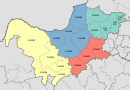
 Location in South Africa | |
| Country | South Africa |
| Province | North West |
| Seat | Vryburg |
| Local municipalities | List
|
| Government | |
| • Type | Municipal council |
| • Mayor | Govan Lobelo |
| Area | |
| • Total | 43,700 km2 (16,900 sq mi) |
| Population (2011)[2] | |
| • Total | 463,815 |
| • Density | 11/km2 (27/sq mi) |
| Racial makeup (2011) | |
| • Black African | 91.4% |
| • Coloured | 4.0% |
| • Indian/Asian | 0.4% |
| • White | 3.9% |
| First languages (2011) | |
| • Tswana | 83.6% |
| • Afrikaans | 7.6% |
| • English | 1.9% |
| • Sotho | 1.8% |
| • Other | 5.1% |
| Time zone | UTC+2 (SAST) |
| Municipal code | DC39 |
Dr Ruth Segomotsi Mompati District Municipality (formerly Bophirima District Municipality[4]) is one of the 4 districts of North West province of South Africa. The seat of Mompati District is Vryburg. The majority of its 439,637 people speak Setswana (2001 Census). The district code is DC39. It is South Africa's largest beef producing district, with Hereford cattle the most popular. It is sometimes called "the Texas of South Africa". Maize and peanuts are important crops produced in the district. The district was renamed after the former Mayor of Vryburg Ruth Mompati.
Geography[]
Neighbours[]
Mompati District is surrounded (clockwise) by:
- the republic of Botswana to the north
- Ngaka Modiri Molema District Municipality to the north-east
- Dr Kenneth Kaunda District Municipality to the south-east
- Lejweleputswa District Municipality (Free State province) to the south-east
- Frances Baard District Municipality (Northern Cape province) to the south
- Kgalagadi District Municipality (Northern Cape province) to the west
Local municipalities[]
The district contains the following 5 local municipalities:
| Local municipality | Population | % | Dominant language |
|---|---|---|---|
| Greater Taung | 177 642 | 38.30% | Tswana |
| Kagisano-Molopo | 105 789 | 22.81% | Tswana |
| Naledi | 66 781 | 14.40% | Tswana |
| Mamusa | 60 355 | 13.01% | Tswana |
| Lekwa-Teemane | 53 248 | 11.48% | Tswana |
Demographics[]
The following statistics are from the 2011 census.
| Language | Population | % |
|---|---|---|
| Tswana | 384 956 | 83.60% |
| Afrikaans | 35 213 | 7.65% |
| English | 8 696 | 1.89% |
| Sotho | 8 118 | 1.76% |
| Xhosa | 7 092 | 1.54% |
| Ndebele | 4 310 | 0.94% |
| Other | 4 287 | 0.93% |
| Zulu | 3 964 | 0.86% |
| Sign language | 1 766 | 0.38% |
| Northern Sotho | 1 211 | 0.26% |
| Tsonga | 481 | 0.10% |
| Venda | 214 | 0.05% |
| Swati | 155 | 0.03% |
Gender[]
| Gender | Population | % |
|---|---|---|
| Female | 239,097 | 51.55% |
| Male | 224,718 | 48.45% |
Ethnic group[]
| Ethnic group | Population | % |
|---|---|---|
| Black African | 423,980 | 91.41% |
| Coloured | 18,346 | 3.96% |
| White | 18,127 | 3.91% |
| Indian/Asian | 1,358 | 0.43% |
Age[]
| Age | Population | % |
|---|---|---|
| 000 - 004 | 50 051 | 11.38% |
| 005 - 009 | 55 303 | 12.58% |
| 010 - 014 | 56 825 | 12.93% |
| 015 - 019 | 52 129 | 11.86% |
| 020 - 024 | 38 481 | 8.75% |
| 025 - 029 | 31 184 | 7.09% |
| 030 - 034 | 26 780 | 6.09% |
| 035 - 039 | 25 234 | 5.74% |
| 040 - 044 | 22 162 | 5.04% |
| 045 - 049 | 18 354 | 4.17% |
| 050 - 054 | 14 801 | 3.37% |
| 055 - 059 | 12 882 | 2.93% |
| 060 - 064 | 10 892 | 2.48% |
| 065 - 069 | 8 520 | 1.94% |
| 070 - 074 | 6 443 | 1.47% |
| 075 - 079 | 4 755 | 1.08% |
| 080 - 084 | 2 993 | 0.68% |
| 085 - 089 | 1 124 | 0.26% |
| 090 - 094 | 469 | 0.11% |
| 095 - 099 | 190 | 0.04% |
| 100 plus | 65 | 0.01% |
Politics[]
Election results[]
Election results for Mompati District in the South African general election, 2004.
- Population 18 and over: 245 386 [55.82% of total population]
- Total votes: 153 517 [34.92% of total population]
- Voting % estimate: 62.56% votes as a % of population 18 and over
| Party | Votes | % |
|---|---|---|
| African National Congress | 124 832 | 81.31% |
| United Christian Democratic Party | 14 626 | 9.53% |
| Democratic Alliance | 4 866 | 3.17% |
| African Christian Democratic Party | 1 708 | 1.11% |
| Pan African Congress | 1 531 | 1.00% |
| Freedom Front Plus | 1 473 | 0.96% |
| Independent Democrats | 938 | 0.61% |
| United Democratic Movement | 777 | 0.51% |
| New National Party | 673 | 0.44% |
| Azanian People's Organisation | 586 | 0.38% |
| EMSA | 254 | 0.17% |
| Inkhata Freedom Party | 247 | 0.16% |
| SOPA | 217 | 0.14% |
| PJC | 141 | 0.09% |
| NA | 135 | 0.09% |
| CDP | 130 | 0.08% |
| UF | 130 | 0.08% |
| TOP | 111 | 0.07% |
| NLP | 56 | 0.04% |
| KISS | 48 | 0.03% |
| Minority Front | 38 | 0.02% |
| Total | 153 517 | 100.00% |
References[]
- ^ "Contact list: Executive Mayors". Government Communication & Information System. Archived from the original on 14 July 2010. Retrieved 22 February 2012.
- ^ a b "Statistics by place". Statistics South Africa. Retrieved 27 September 2015.
- ^ "Statistics by place". Statistics South Africa. Retrieved 27 September 2015.
- ^ "New Municipal Names". Municipal Demarcation Board. Archived from the original on 2006-09-24. Retrieved 2009-03-08.
External links[]

- District Municipalities of North West (South African province)
- Dr Ruth Segomotsi Mompati District Municipality