Moretele Local Municipality
Moretele | |
|---|---|
 Seal | |
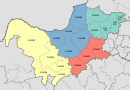
 Location in the North West | |
| Country | South Africa |
| Province | North West |
| District | Bojanala Platinum |
| Seat | Makapanstad |
| Wards | 26 |
| Government | |
| • Type | Municipal council |
| • Mayor | Cllr Andries Monageng (ANC) |
| • PR Cllr and ACG Whip in Council | Cllr. Shangy Mbekwa |
| Area | |
| • Total | 1,379 km2 (532 sq mi) |
| Population (2011)[2] | |
| • Total | 186,947 |
| • Density | 140/km2 (350/sq mi) |
| Racial makeup (2011) | |
| • Black African | 99.4% |
| • Coloured | 0.2% |
| • Indian/Asian | 0.1% |
| • White | 0.2% |
| First languages (2011) | |
| • Tswana | 51.7% |
| • Tsonga | 18.4% |
| • Northern Sotho | 13.9% |
| • Zulu | 3.5% |
| • Other | 12.5% |
| Time zone | UTC+2 (SAST) |
| Municipal code | NW371 |
Moretele is a local municipality in Bojanala Platinum District Municipality, North West Province, South Africa. Population: 180,000.
Main places[]
The 2001 census divided the municipality into the following main places:[3]
| Place | Code | Area (km2) | Population | Most spoken language |
|---|---|---|---|---|
| 60101 | 9.42 | 120 | Northern Sotho | |
| 60102 | 4.99 | 154 | English | |
| 60103 | 180.68 | 32,023 | Tswana | |
| 60104 | 459.19 | 45,114 | Tswana | |
| 60105 | 109.41 | 1,111 | Tswana | |
| 60106 | 45.81 | 24,329 | Tswana | |
| 60107 | 228.03 | 11,024 | Tswana | |
| 60108 | 0.61 | 820 | Tswana | |
| 60109 | 4.11 | 114 | Zulu | |
| 60110 | 84.98 | 28,839 | Tsonga | |
| 60111 | 104.32 | 11,365 | Tswana | |
| Mogogelo | 60112 | 26.02 | 10,500 | Tsonga |
| Moretele | 60113 | 30.44 | 4,933 | Northern Sotho |
| Temba | 60114 | 2.19 | 5,310 | Tsonga |
| 60115 | 15.15 | 465 | Tsonga | |
| 60116 | 64.32 | 1,687 | Zulu |
Ruigtesloot
Politics[]
The municipal council consists of fifty-two members elected by mixed-member proportional representation. Twenty-six councillors are elected by first-past-the-post voting in twenty-six wards, while the remaining twenty-six are chosen from party lists so that the total number of party representatives is proportional to the number of votes received. In the election of 3 August 2016 the African National Congress (ANC) won a majority of thirty-eight seats on the council.
The following table shows the results of the election.[4][5]
| Party | Votes | Seats | ||||||
|---|---|---|---|---|---|---|---|---|
| Ward | List | Total | % | Ward | List | Total | ||
| ANC | 36,394 | 36,751 | 73,145 | 72.1 | 26 | 12 | 38 | |
| EFF | 8,030 | 7,850 | 15,880 | 15.6 | 0 | 8 | 8 | |
| Democratic Alliance | 3,597 | 3,784 | 7,381 | 7.3 | 0 | 4 | 4 | |
| 529 | 612 | 1,141 | 1.1 | 0 | 1 | 1 | ||
| COPE | 340 | 554 | 894 | 0.9 | 0 | 1 | 1 | |
| African People's Convention | 355 | 408 | 763 | 0.8 | 0 | 0 | 0 | |
| Independent | 618 | – | 618 | 0.6 | 0 | – | 0 | |
| PAC | 207 | 247 | 454 | 0.5 | 0 | 0 | 0 | |
| 144 | 292 | 436 | 0.4 | 0 | 0 | 0 | ||
| ACDP | 88 | 228 | 316 | 0.3 | 0 | 0 | 0 | |
| 136 | 105 | 241 | 0.2 | 0 | 0 | 0 | ||
| IFP | 89 | 146 | 235 | 0.2 | 0 | 0 | 0 | |
| Total | 50,527 | 50,977 | 101,504 | 100.0 | 26 | 26 | 52 | |
| Spoilt votes | 996 | 1,047 | 2,043 | |||||
References[]
- ^ "Contact list: Executive Mayors". Government Communication & Information System. Archived from the original on 14 July 2010. Retrieved 22 February 2012.
- ^ Jump up to: a b c "Statistics by place". Statistics South Africa. Retrieved 27 September 2015.
- ^ Lookup Tables - Statistics South Africa
- ^ "Results Summary – All Ballots: Moretele" (PDF). Independent Electoral Commission. Retrieved 21 April 2017.
- ^ "Seat Calculation Detail: Moretele" (PDF). Independent Electoral Commission. Retrieved 21 April 2017.
External links[]
| show Municipalities of the North West |
|---|
| show Authority control |
|---|
Coordinates: 25°10′S 28°5′E / 25.167°S 28.083°E

This North West Province location article is a stub. You can help Wikipedia by . |
- Local municipalities of the Bojanala Platinum District Municipality
- North West (South Africa) geography stubs