Duntisbourne Rouse
| Duntisbourne Rouse | |
|---|---|
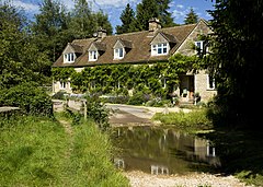
 The ford at Duntisbourne Rouse | |
 Duntisbourne Rouse Location within Gloucestershire | |
| Population | 70 (2001) |
| Civil parish |
|
| District |
|
| Shire county | |
| Region | |
| Country | England |
| Sovereign state | United Kingdom |
| Post town | CIRENCESTER |
| Postcode district | GL7 |
| Dialling code | 01285 |
| Police | Gloucestershire |
| Fire | Gloucestershire |
| Ambulance | South Western |
| UK Parliament |
|
Duntisbourne Rouse is a village and civil parish in Gloucestershire, England. It lies in the Cotswolds, an Area of Outstanding Natural Beauty. At the 2001 census, it had a population of 70.[1]
History[]
Toponymy[]
The village was recorded as Duntesburne in 1055 and Duntesborne in the 1086 Domesday Book, the name coming from the Old English for "stream of a man called Dunt".[2] The manorial affix came from a family called le Rous, who were at one time the lords of the manor.[2][3] By 1287, the village was known as Duntesbourn Rus.[2]
Governance[]
The parishes of Duntisbourne Rouse and the neighbouring village of Duntisbourne Abbots are covered by a single 7-person council, the Duntisbournes Parish Council.[4] Duntisbourne Rouse is part of the Ermin ward of the district of Cotswold and is represented by Councillor Nicholas Parsons, a member of the Conservative Party.[5] Duntisbourne Rouse is part of the constituency of Cotswold, represented at parliament by Conservative MP Geoffrey Clifton-Brown.[6] It was part of the South West England constituency of the European Parliament prior to Britain leaving the European Union in January 2020.
Geography[]
Duntisbourne Rouse is in the county of Gloucestershire, and lies within the Cotswolds, a range of hills designated an Area of Outstanding Natural Beauty. It is approximately 16 km (9.9 mi) south-east of Gloucester and approximately 6.5 km (4.0 mi) north-west of Cirencester. Nearby villages include Duntisbourne Abbots, Duntisbourne Leer, Bagendon and Daglingworth.
Church[]
The church at Duntisbourne Rouse is dedicated to St. Michael and is located on the side of a hill overlooking the Dunt valley.[7] The church, which dates from Saxon times, includes a small crypt beneath the building.[8] The chancel was added in Norman times.[9] The choir stalls contain five misericords.[9] Whether they were originally installed in this church or imported from elsewhere is unknown.[10] The windows date from the 12th century, the tower from the 15th century and the pews and panelling from the 18th century.[7] The organ was donated by Vera, Charlotte and Jeanne Beauchamp in memory of their sister, modernist writer Katherine Mansfield. A plaque to this effect is located on the side of the organ.[11] The church was designated a Grade I listed building by English Heritage on 26 November 1958.[12]
References[]
| Wikimedia Commons has media related to Duntisbourne Rouse. |
- ^ "Parish Headcounts: Cotswold". Neighbourhood Statistics. Office for National Statistics. Retrieved 23 December 2012.
- ^ a b c Mills, A. D. (1998). Dictionary of English Place-Names. Oxford University Press. p. 120. ISBN 0-19-280074-4.
- ^ Hall, Michael (1993). Stratford-Upon-Avon and the Cotswolds. The Pevensey Press. p. 76. ISBN 0-907115-68-3.
- ^ "Duntisbournes Parish Council". Gloucestershire County Council. 4 September 2007. Retrieved 3 June 2008.
- ^ "COTSWOLD — Find your councillor". Cotswold District Council. Retrieved 3 June 2008.
- ^ "Cotswold — Constituency — Conservative Party". Conservative Party. Archived from the original on 17 October 2006. Retrieved 26 April 2008.
- ^ a b "Parish of Duntisbourne Rous". ParishConnections.org. 2008. Retrieved 26 December 2008.
- ^ Fewins, Clive (2005). The Church Explorer's Handbook. SCM-Canterbury Press Ltd. p. 126. ISBN 1-85311-622-X.
- ^ a b Betjeman, John (1958). Collins Guide to English Parish Churches. Collins. p. 172.
- ^ Remnant, G. L.; Mary Désirée Anderson (1969). A Catalogue of Misericords in Great Britain. Oxford University Press. p. 48. ISBN 0-19-817164-1.
- ^ "Organ Plaque". Katherine Mansfield Society. 2008. Retrieved 27 September 2009.
- ^ "Church Of St Michael". Heritage Gateway. English Heritage. Retrieved 5 September 2010.
- Villages in Gloucestershire
- Cotswold District

