Durham, Maine
Durham, Maine | |
|---|---|
 Union Church, also used as town hall | |
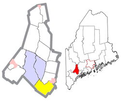 Location of Durham (in yellow) in Androscoggin County and the state of Maine | |
 Durham, Maine Location in the United States | |
| Coordinates: 43°58′21″N 70°7′23″W / 43.97250°N 70.12306°WCoordinates: 43°58′21″N 70°7′23″W / 43.97250°N 70.12306°W | |
| Country | United States |
| State | Maine |
| County | Androscoggin |
| Incorporation | February 17, 1789 |
| Villages | Crossman Corner Plummer Mill Shiloh South Durham South West Bend West Durham |
| Area | |
| • Total | 39.04 sq mi (101.11 km2) |
| • Land | 38.28 sq mi (99.14 km2) |
| • Water | 0.76 sq mi (1.97 km2) |
| Elevation | 167 ft (51 m) |
| Population | |
| • Total | 3,848 |
| • Estimate (2014[3]) | 3,908 |
| • Density | 100.5/sq mi (38.8/km2) |
| Time zone | UTC-5 (Eastern (EST)) |
| • Summer (DST) | UTC-4 (EDT) |
| ZIP code | 04222 |
| Area code(s) | 207 |
| FIPS code | 23-19105 |
| GNIS feature ID | 0582448 |

Durham is a town in Androscoggin County, Maine, United States. The population was 3,848 at the 2010 census. It is included in both the Lewiston-Auburn, Maine Metropolitan Statistical Area and the Lewiston-Auburn, Maine Metropolitan New England City and Town Area.
History[]
Durham was named after County Durham, England, the ancestral home of the town's first settler.[4] It was previously known as Royallsborough, named after Isaac Royall Jr.[5]
Geography[]
According to the United States Census Bureau, the town has a total area of 39.04 square miles (101.11 km2), of which 38.28 square miles (99.14 km2) is land and 0.76 square miles (1.97 km2) is water.[1]
Durham is bordered by Pownal, Auburn, Freeport, New Gloucester, Brunswick, Lewiston, Lisbon Falls, and Topsham.
Durham is considered a "gateway" town because it connects two major Maine communities, the Greater Portland Area with the Lewiston–Auburn Area.
Demographics[]
| Historical population | |||
|---|---|---|---|
| Census | Pop. | %± | |
| 1790 | 724 | — | |
| 1800 | 1,242 | 71.5% | |
| 1810 | 1,772 | 42.7% | |
| 1820 | 1,562 | −11.9% | |
| 1830 | 1,731 | 10.8% | |
| 1840 | 1,836 | 6.1% | |
| 1850 | 1,886 | 2.7% | |
| 1860 | 1,623 | −13.9% | |
| 1870 | 1,350 | −16.8% | |
| 1880 | 1,253 | −7.2% | |
| 1890 | 1,111 | −11.3% | |
| 1900 | 1,230 | 10.7% | |
| 1910 | 1,625 | 32.1% | |
| 1920 | 1,144 | −29.6% | |
| 1930 | 806 | −29.5% | |
| 1940 | 784 | −2.7% | |
| 1950 | 1,050 | 33.9% | |
| 1960 | 1,086 | 3.4% | |
| 1970 | 1,264 | 16.4% | |
| 1980 | 2,074 | 64.1% | |
| 1990 | 2,842 | 37.0% | |
| 2000 | 3,381 | 19.0% | |
| 2010 | 3,848 | 13.8% | |
| 2014 (est.) | 3,908 | [3] | 1.6% |
| U.S. Decennial Census[6] | |||
2010 census[]
As of the census[2] of 2010, there were 3,848 people, 1,496 households, and 1,143 families living in the town. The population density was 100.5 inhabitants per square mile (38.8/km2). There were 1,548 housing units at an average density of 40.4 per square mile (15.6/km2). The racial makeup of the town was 97.8% White, 0.3% African American, 0.1% Native American, 0.5% Asian, 0.2% from other races, and 1.0% from two or more races. Hispanic or Latino of any race were 0.8% of the population.
There were 1,496 households, of which 33.5% had children under the age of 18 living with them, 63.6% were married couples living together, 7.5% had a female householder with no husband present, 5.3% had a male householder with no wife present, and 23.6% were non-families. 16.6% of all households were made up of individuals, and 4% had someone living alone who was 65 years of age or older. The average household size was 2.57 and the average family size was 2.85.
The median age in the town was 41.2 years. 22.3% of residents were under the age of 18; 5.5% were between the ages of 18 and 24; 29.1% were from 25 to 44; 33.8% were from 45 to 64; and 9.3% were 65 years of age or older. The gender makeup of the town was 50.6% male and 49.4% female.
2000 census[]
As of the census[7] of 2000, there were 3,381 people, 1,226 households, and 980 families living in the town. The population density was 88.7 people per square mile (34.3/km2). There were 1,257 housing units at an average density of 33.0 per square mile (12.7/km2). The racial makeup of the town was 98.96% White, 0.12% African American, 0.15% Native American, 0.27% Asian, 0.09% from other races, and 0.41% from two or more races. Hispanic or Latino of any race were 0.65% of the population.
There were 1,226 households, out of which 38.9% had children under the age of 18 living with them, 70.6% were married couples living together, 5.9% had a female householder with no husband present, and 20.0% were non-families. 12.4% of all households were made up of individuals, and 3.0% had someone living alone who was 65 years of age or older. The average household size was 2.75 and the average family size was 3.02.
In the town, the population was spread out, with 26.9% under the age of 18, 5.2% from 18 to 24, 35.5% from 25 to 44, 25.5% from 45 to 64, and 6.8% who were 65 years of age or older. The median age was 37 years. For every 100 females, there were 99.5 males. For every 100 females age 18 and over, there were 99.2 males.
The median income for a household in the town was $53,846, and the median income for a family was $55,028. Males had a median income of $35,174 versus $28,342 for females. The per capita income for the town was $20,883. About 5.9% of families and 6.6% of the population were below the poverty line, including 8.2% of those under age 18 and 9.8% of those age 65 or over.
Voter registration
| Voter Registration and Party Enrollment as of January 2015[8] | |||||
|---|---|---|---|---|---|
| Party | Total Voters | Percentage | |||
| Unenrolled | 1,282 | 40.3% | |||
| Republican | 946 | 29.7% | |||
| Democratic | 772 | 24.2% | |||
| Green Independent | 179 | 5.6% | |||
| Total | 3,179 | 100% | |||
Government[]
Durham is in Maine's 2nd congressional district, Maine Senate District 22,[9] and Maine House of Representatives District 46.[10]
Education[]
- Durham Community School is a public school operated by the . The school provides for the education of students in grades K through 8.
- Education of a majority of the students in grades 9 through 12 is provided by Freeport High School.
- Durham is a part of Regional School Unit #5, Becky Foley is the Superintendent.[11]
Amenities[]
The privately owned Margerison Airport is located between Hallowell Road and Royalsborough Road, just north of Rabbit Road. Its FAA identifier is ME75, and it was activated in 1979. It has two unpaved runways — headings 9/27 and 15/33. Its area control center is Boston Center, while its flight service station is Bangor.[12]
Notable people[]
- Frank Sandford, founder and leader of an apocalyptic Christian sect known as "The Kingdom"
- Edward H. Hill, founder of Central Maine Medical Center
- Stephen King spent part of his childhood in Durham. He based the fictional town of Jerusalem's Lot on it.
References[]
- ^ a b "US Gazetteer files 2010". United States Census Bureau. Retrieved 2012-12-16.
- ^ a b "U.S. Census website". United States Census Bureau. Retrieved 2012-12-16.
- ^ a b "Annual Estimates of the Resident Population for Incorporated Places: April 1, 2010 to July 1, 2014". Archived from the original on May 23, 2015. Retrieved June 4, 2015.
- ^ Yates, Edgar A.P. (Jun 13, 1928). "Some Maine town names". The Lewiston Daily Sun. p. 4. Retrieved 17 October 2015.
- ^ "Maine register, state year-book and legislative manual - 1893-1894". dcms.lds.org.
- ^ "Census of Population and Housing". Census.gov. Retrieved June 4, 2015.
- ^ "U.S. Census website". United States Census Bureau. Retrieved 2008-01-31.
- ^ http://maine.gov/sos/cec/elec/data/r-e-active.pdf
- ^ "Archived copy". Maine Senate. Archived from the original on 5 October 2016. Retrieved 4 October 2016.CS1 maint: archived copy as title (link)
- ^ "Maine House Districts". Towns in Each District. Retrieved 4 October 2016.
- ^ "Administration - Regional School Unit 5". www.rsu5.org. Retrieved 2019-12-04.
- ^ ME75 Margerison Airpor, Durham, Maine - AirNav.com
External links[]
- Town of Durham, Maine
- Varney, George J. (1886), Gazetteer of the state of Maine. Durham, Maine: Samantha
Municipalities and communities of Androscoggin County, Maine, United States | ||
|---|---|---|
County seat: Auburn | ||
| Cities |
|  |
| Towns | ||
| CDPs | ||
| Other communities | ||
| ||
- Durham, Maine
- Towns in Androscoggin County, Maine
- Towns in Maine