Lisbon, Maine
Lisbon, Maine | |
|---|---|
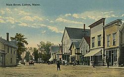 Main Street c. 1914 | |
 Seal | |
 Location of the town of Lisbon (in yellow) in Androscoggin County and the state of Maine | |
 Lisbon, Maine Location in the United States | |
| Coordinates: 44°1′21″N 70°4′47″W / 44.02250°N 70.07972°WCoordinates: 44°1′21″N 70°4′47″W / 44.02250°N 70.07972°W | |
| Country | United States |
| State | Maine |
| County | Androscoggin |
| Incorporated | June 22, 1799 |
| Villages | Lisbon Lisbon Center Lisbon Falls |
| Area | |
| • Total | 23.82 sq mi (61.69 km2) |
| • Land | 22.82 sq mi (59.10 km2) |
| • Water | 1.00 sq mi (2.59 km2) |
| Elevation | 200 ft (61 m) |
| Population | |
| • Total | 9,009 |
| • Estimate (2012[2]) | 8,943 |
| • Density | 394.8/sq mi (152.4/km2) |
| Time zone | UTC−5 (Eastern (EST)) |
| • Summer (DST) | UTC−4 (EDT) |
| ZIP codes | 04250, 04252 |
| Area code(s) | 207 |
| FIPS code | 23-40035 |
| GNIS feature ID | 0582563 |
| Website | lisbonme.org |

Lisbon is a town in Androscoggin County, Maine. The population was 9,009 at the 2010 census. It is included in both the Lewiston-Auburn, Maine metropolitan statistical area and the Lewiston–Auburn, Maine Metropolitan New England city and town area. The town of Lisbon includes the villages of Lisbon and Lisbon Falls.
History[]
The community was originally part of Bowdoin, a township within the Kennebec Purchase. But because travel to attend town meetings was difficult, on June 22, 1799, the General Court of Massachusetts divided Bowdoin in two to create Thompsonborough. Residents, however, soon grew dissatisfied with the long name. Consequently, it would be renamed in 1802 as Lisbon, after Lisbon in Portugal. In 1808, Lisbon annexed the remainder of Little River Plantation (part of the Pejepscot Purchase) as Lisbon Falls. In 1840, part of Lisbon was set off as Webster.[4]
With fertile and easily cultivated soil, farming was an early industry. Sawmills and gristmills were built using water power from the streams. Larger brick mills followed to manufacture textiles. In 1864, the Worumbo Mill was established to produce woolens,[5] and would remain a principal employer until it burned in 1987. Today, the small mill town is largely a bedroom community for companies like Bath Iron Works and L.L.Bean and increasingly for people working in the Portland area.[6]
Geography[]
According to the United States Census Bureau, the town has a total area of 23.82 square miles (61.69 km2), of which 22.82 square miles (59.10 km2) is land and 1.00 square mile (2.59 km2) is water.[1] Lisbon is drained by the Sabattus River, Little River and Androscoggin River.
Demographics[]
| Historical population | |||
|---|---|---|---|
| Census | Pop. | %± | |
| 1810 | 1,614 | — | |
| 1820 | 2,240 | 38.8% | |
| 1830 | 2,423 | 8.2% | |
| 1840 | 1,532 | −36.8% | |
| 1850 | 1,495 | −2.4% | |
| 1860 | 1,376 | −8.0% | |
| 1870 | 2,014 | 46.4% | |
| 1880 | 2,641 | 31.1% | |
| 1890 | 3,120 | 18.1% | |
| 1900 | 3,603 | 15.5% | |
| 1910 | 4,116 | 14.2% | |
| 1920 | 4,091 | −0.6% | |
| 1930 | 4,002 | −2.2% | |
| 1940 | 4,123 | 3.0% | |
| 1950 | 4,318 | 4.7% | |
| 1960 | 5,042 | 16.8% | |
| 1970 | 6,544 | 29.8% | |
| 1980 | 8,769 | 34.0% | |
| 1990 | 9,457 | 7.8% | |
| 2000 | 9,077 | −4.0% | |
| 2010 | 9,009 | −0.7% | |
| 2014 (est.) | 8,883 | [7] | −1.4% |
| U.S. Decennial Census[8] | |||
2010 census[]
As of the census[3] of 2010, there were 9,009 people, 3,696 households, and 2,477 families living in the town. The population density was 394.8 inhabitants per square mile (152.4/km2). There were 3,948 housing units at an average density of 173.0 per square mile (66.8/km2). The racial makeup of the town was 96.2% White; 0.6% African American; 0.5% Native American; 0.5% Asian; 0.3% from other races; and 1.9% from two or more races. Hispanic or Latino of any race were 1.0% of the population.
There were 3,696 households, of which 32.4% had children under the age of 18 living with them; 49.4% were married couples living together; 11.7% had a female householder with no husband present,; 5.9% had a male householder with no wife present, and 33.0% were non-families. 26.0% of all households were made up of individuals; and 8.8% had someone living alone who was 65 years of age or older. The average household size was 2.43 and the average family size was 2.90.
The median age in the town was 39.4 years. 23.5% of residents were under the age of 18; 8.3% were between the ages of 18 and 24; 26.7% were from 25 to 44; 28.8% were from 45 to 64; and 12.8% were 65 years of age or older. The gender makeup of the town was 49.0% male and 51.0% female.
2000 census[]
As of the census[9] of 2000, there were 9,077 people, 3,608 households, and 2,485 families living in the town. The population density was 384.5 people per square mile (148.4/km2). There were 3,789 housing units at an average density of 160.5 per square mile (62.0/km2). The racial makeup of the town was 97.41% White; 0.65% African American; 0.22% Native American; 0.39% Asian, 0.10% Pacific Islander, 0.31% from other races; and 0.93% from two or more races. Hispanic or Latino of any race were 0.74% of the population.
There were 3,608 households, out of which 34.1% had children under the age of 18 living with them, 53.3% were married couples living together, 11.2% had a female householder with no husband present, and 31.1% were non-families. 24.4% of all households were made up of individuals, and 9.1% had someone living alone who was 65 years of age or older. The average household size was 2.51 and the average family size was 2.97.
In the town, the population was spread out, with 26.5% under the age of 18; 8.3% from 18 to 24; 31.7% from 25 to 44; 21.9% from 45 to 64; and 11.6% who were 65 years of age or older. The median age was 36 years. For every 100 females, there were 96.2 males. For every 100 females age 18 and over, there were 93.2 males.
The median income for a household in the town was $38,115, and the median income for a family was $42,614. Males had a median income of $32,107 versus $21,099 for females. The per capita income for the town was $17,263. About 6.7% of families and 8.4% of the population were below the poverty line, including 10.6% of those under age 18 and 8.3% of those age 65 or over.
Voter registration
| Voter Registration and Party Enrollment as of June 2014[10] | |||||
|---|---|---|---|---|---|
| Party | Total Voters | Percentage | |||
| Unenrolled | 2,642 | 41.4% | |||
| Democratic | 1768 | 27.7% | |||
| Republican | 1768 | 27.7% | |||
| Green Independent | 204 | 3.2% | |||
| Total | 6,382 | 100% | |||
Education[]
The Lisbon School Department includes three schools: Lisbon Community School, Philip W. Sugg Middle School and Lisbon High School.
Rick Green is the Superintendent of Schools.[11]
Notable people[]
- Dale J. Crafts, state legislator
- William Dunn, sailor
- Howard Gerrish, author and teacher
- John Gould, columnist
- Hannah Hanson Kinney, alleged murderer
- Louis A. Jack, state legislator and President of the Maine Board of Trade
- Stephen King, writer
- Garrett Mason, state legislator
- Gina Mason, state legislator
- Greg Moore, hockey forward
- James Tierney, politician
Pop culture[]
Lisbon, Maine, was featured in the Hulu web television series 11.22.63, as the hometown of the lead character, Jake Epping.
References[]
- ^ Jump up to: a b "US Gazetteer files 2010". United States Census Bureau. Retrieved 2012-12-16.
- ^ "Population Estimates". United States Census Bureau. Archived from the original on 2013-06-11. Retrieved 2013-07-06.
- ^ Jump up to: a b "U.S. Census website". United States Census Bureau. Retrieved 2012-12-16.
- ^ Coolidge, Austin J.; John B. Mansfield (1859). A History and Description of New England. Boston, Massachusetts: A.J. Coolidge. p. 196.
coolidge mansfield history description new england 1859.
- ^ Varney, George J. (1886), Gazetteer of the state of Maine. Lisbon, Boston: Russell, archived from the original on 2017-05-05, retrieved 2007-09-16
- ^ "Lisbon, Androscoggin County - Maine Genealogy". www.mainegenealogy.net. Retrieved 13 April 2018.
- ^ "Annual Estimates of the Resident Population for Incorporated Places: April 1, 2010 to July 1, 2014". Archived from the original on May 23, 2015. Retrieved June 4, 2015.
- ^ "Census of Population and Housing". Census.gov. Retrieved June 4, 2015.
- ^ "U.S. Census website". United States Census Bureau. Retrieved 2008-01-31.
- ^ http://www.pressherald.com/interactive/maine_registered_voters_democrat_republican_independent_green/
- ^ "Lisbon School Dept. Central Office". Lisbon Schools. Archived from the original on 2009-12-06. Retrieved 2012-08-06.
External links[]
| show Municipalities and communities of Androscoggin County, Maine, United States |
|---|

| show Authority control |
|---|
- Lisbon, Maine
- Towns in Androscoggin County, Maine
- Towns in Maine