East Aceh Regency
East Aceh Regency
Kabupaten Aceh Timur | |
|---|---|
 Seal | |
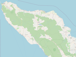
 Location within Aceh | |
| Coordinates: 4°37′N 97°37′E / 4.617°N 97.617°E | |
| Country | Indonesia |
| Region | Sumatra |
| Province | Aceh |
| Established | 1956 |
| Regency seat | Idi Rayeuk |
| Government | |
| • Regent | Hasballah Muhammad Thaib |
| • Vice Regent | Syahrul Syamaun |
| Area | |
| • Total | 6,040.60 km2 (2,332.29 sq mi) |
| Population (2020 Census)[1] | |
| • Total | 422,401 |
| • Density | 70/km2 (180/sq mi) |
| Time zone | UTC+7 (IWST) |
| Area code | (+62) 646 |
| Website | acehtimurkab |


East Aceh Regency (Indonesian: Kabupaten Aceh Timur) is a regency in eastern Aceh Special Region (Nanggroe Aceh Darussalam) of Indonesia. It is located on the island of Sumatra. The regency covers an area of 6,040.60 square kilometres and had a population of 360,475 at the 2010 Census[2] and 422,401 at the 2020 Census.[3]
The regency borders the Malacca Strait to the north-east, the city of Langsa and Aceh Tamiang Regency to the south-east, Gayo Lues Regency to the south, and Central Aceh Regency, Bener Meriah Regency and North Aceh Regency to the west.
Economy[]
This regency is rich in petroleum, more so than the North Aceh and regencies. Fishing employs many people in the regency but little of it is exported; people depend on it for food.[4] The main fishing centre in the regency is in . The regency also has several food-plant based industries producing tofu, tempeh and sun-dried banana chips.[4] Some areas are under plantation exploitation for palm oil and rubber, although there is only one state-owned company (TPN I) operating in the area. Plantations also produce cacao and chocolate and in the area iron ore and lead is mined.[4]
Administrative districtss[]
The regency is divided administratively into twenty-four districts (kecamatan), listed below with their areas and their populations at the 2010 Census[5] and 2020 Census.[6]
| Name | Area in km2[7] |
Pop'n Census 2010[8] |
Pop'n Census 2020[9] |
|---|---|---|---|
| Serba Jadi | 2,165.66 | 5,766 | 6,701 |
| Simpang Jernih | 544.63 | 3,397 | 3,626 |
| Peunaron | 79.74 | 8,206 | 9,154 |
| Birem Bayeun | 253.68 | 25,330 | 28,710 |
| Rantau Selamat | 159.80 | 11,223 | 12,372 |
| Sungai Raya | 159.00 | 10,672 | 12,672 |
| Peureulak | 318.02 | 39,691 | 46,245 |
| Peureulak Timur (East Peureulak) |
182.70 | 12,601 | 14,457 |
| Peureulak Barat (West Peureulak) |
92.30 | 13,633 | 17,367 |
| Ranto Peureulak | 129.00 | 21,945 | 25,945 |
| Idi Rayeuk | 79.60 | 33,136 | 39,086 |
| Peudawa | 75.90 | 10,274 | 12,958 |
| Banda Alam | 90.95 | 7,296 | 8,651 |
| Idi Tunong | 74.70 | 8,895 | 11,305 |
| Darul Ihsan | 54.50 | 5,447 | 7,343 |
| Idi Timur (East Idi) |
55.15 | 5,210 | 6,762 |
| Darul Aman | 131.50 | 17,043 | 20,569 |
| Nurussalam | 137.07 | 15,308 | 17,843 |
| Darul Falah | 42.40 | 2,902 | 3,752 |
| Julok | 234.36 | 23,884 | 26,835 |
| Indra Makmur | 89.05 | 15,772 | 16,416 |
| Pante Bidari (or Pante Beudari) |
233.25 | 21,490 | 25,588 |
| Simpang Ulim | 123.80 | 18,136 | 21,136 |
| Madat | 200.84 | 23,218 | 26,908 |
| Totals | 6,040.60 | 360,475 | 422,401 |
References[]
- ^ Badan Pusat Statistik, Jakarta, 2021.
- ^ Biro Pusat Statistik, Jakarta, 2011.
- ^ Badan Pusat Statistik, Jakarta, 2021.
- ^ Jump up to: a b c "Aceh Timur" (PDF). Aceh Investment and Promotion Board. February 2010. Archived from the original (PDF) on July 7, 2011. Retrieved December 20, 2010.
- ^ Biro Pusat Statistik, Jakarta, 2011.
- ^ Badan Pusat Statistik, Jakarta, 2021.
- ^ Badan Pusat Statistik, Jakarta, 2021.
- ^ Biro Pusat Statistik, Jakarta, 2011.
- ^ Badan Pusat Statistik, Jakarta, 2021.

| show Authority control |
|---|
- Regencies of Aceh