West Aceh Regency
West Aceh Regency
Kabupaten Aceh Barat | |
|---|---|
 | |
 Seal | |
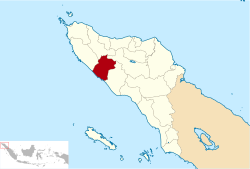 Location within Aceh | |
| Coordinates: 4°27′N 96°11′E / 4.450°N 96.183°E | |
| Country | Indonesia |
| Region | Sumatra |
| Province | Aceh |
| Established | 1956 |
| Regency seat | Meulaboh |
| Government | |
| • Regent | Ramli |
| • Vice Regent | Banta Puteh Syam |
| Area | |
| • Total | 2,927.95 km2 (1,130.49 sq mi) |
| Population (2020 Census)[1] | |
| • Total | 198,736 |
| • Density | 68/km2 (180/sq mi) |
| Time zone | UTC+7 (IWST) |
| Area code | (+62) 655 |
| Website | acehbaratkab.go.id |
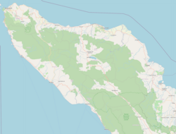
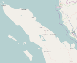


West Aceh Regency is a regency (Indonesian: kabupaten) in the Aceh special region of Indonesia. It is located on the island of Sumatra. The regency currently covers an area of 2,927.95 square kilometres and had a population of 173,558 at the 2010 Census[2] and 198,736 at the 2020 Census.[3] The town of Meulaboh remains the seat of the regency government (notwithstanding unsubstantiated reports that on 8 July 2013 it was separated out as an independent city). The regency is a palm oil-producing area.[4] Some of the people of the regency are Minangkabau-descended Aneuk Jamee.[5]
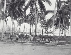
The regency was among the hardest-hit areas during the 2004 Indian Ocean earthquake.[citation needed]
The regency is bordered by the regencies of Aceh Jaya to the west, Pidie to the north, Central Aceh to the northeast, and Nagan Raya to the southeast, and by the Indian Ocean to the southwest.
Administrative districts[]
The regency was divided administratively into twelve districts (kecamatan), listed below with their areas and populations at the 2010 Census[6] and the 2020 Census.[7] The table also includes the location of the district administrative centres, and the number of administrative villages (rural desa and urban kelurahan) in each district.
| Name | Area in km2) |
Pop'n Census 2010 |
Pop'n Census 2020 |
Admin centre |
No. of vill. |
|---|---|---|---|---|---|
| Johan Pahlawan | 44.91 | 56,050 | 64,646 | Meulaboh | 21 |
| Samatiga | 140.69 | 13,322 | 15,656 | Suak Timah | 32 |
| Bubon | 129.58 | 6,545 | 6,817 | Banda Layung | 17 |
| Arongan Lambalek | 130.06 | 10,609 | 11,871 | Drien Rampak | 27 |
| Woyla | 249.04 | 12,073 | 13,576 | Kuala Bhee | 43 |
| Woyla Barat (West Woyla) |
123.00 | 6,858 | 7,837 | Pasi Mali | 24 |
| Woyla Timur (East Woyla) |
132.60 | 4,138 | 5,144 | Tangkeh | 26 |
| Kaway XVI | 510.18 | 18,753 | 21,216 | Keudee Aron | 44 |
| Meureubo | 112.87 | 26,510 | 30,066 | Meureubo | 26 |
| Pantai Ceuremen | 490.25 | 9,635 | 11,133 | Pante Ceureumen | 25 |
| Panton Reu | 83.04 | 5,671 | 6,586 | Meutulang | 19 |
| Sungai Mas | 781.73 | 3,394 | 4,188 | Kajeung | 18 |
| Totals | 2,927.95 | 173,558 | 198,736 | Meulaboh | 322 |
See also[]
References[]
- ^ Badan Pusat Statistik, Jakarta, 2021.
- ^ Biro Pusat Statistik, Jakarta, 2011.
- ^ Badan Pusat Statistik, Jakarta, 2021.
- ^ Indonesia. Departemen Penerangan; Japenpa Foreign Languages Publishing Institute (1975). Indonesia handbook. Dept. of Information, Republic of Indonesia. Retrieved 20 December 2010.
- ^ Davies, Matthew N. (2006). Indonesia's war over Aceh: last stand on Mecca's porch. Taylor & Francis. pp. 21–. ISBN 978-0-415-37239-8. Retrieved 20 December 2010.
- ^ Biro Pusat Statistik, Jakarta, 2011.
- ^ Badan Pusat Statistik, Jakarta, 2021.

| show Authority control |
|---|
Coordinates: 4°27′N 96°11′E / 4.450°N 96.183°E
This Aceh location article is a stub. You can help Wikipedia by . |
- Articles with short description
- Regencies of Aceh
- Aceh geography stubs