Subulussalam
Subulussalam | |
|---|---|
| Other transcription(s) | |
| • Jawoë | سبل السلام[citation needed] |
 Coat of arms | |
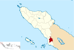 Location within Aceh | |
| Coordinates: 2°38′32″N 98°0′15″E / 2.64222°N 98.00417°ECoordinates: 2°38′32″N 98°0′15″E / 2.64222°N 98.00417°E | |
| Country | Indonesia |
| Region | Sumatra |
| Province | Aceh |
| City | 2 January 2007 |
| Government | |
| • Mayor | Merah Sakti Kombih |
| • Vice Mayor | Salmaza Kombih |
| Area | |
| • Total | 1,391 km2 (537 sq mi) |
| Population (2020 Census) | |
| • Total | 90,751 |
| • Density | 65/km2 (170/sq mi) |
| [1] | |
| Time zone | UTC+7 (IWST) |
| Area code | (+62) 627 |
| Website | subulussalamkota.go.id |
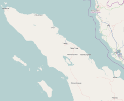


Subulussalam is a city (Indonesian: kota) in the south of Aceh province of Indonesia.[2] It is located inland on the island of Sumatra. On 2 January 2007, the provincial government of Aceh declared Subulussalam to be an independent city as a result of the administration being separated from that of Aceh Singkil Regency. of which it was formerly a part.[3] It is located at 2°38′32″N 98°00′15″E / 2.6423°N 98.0041°E.[2][4][5][6] It covers an area of 1,391 km2, and it had a population of 67,446 at the 2010 Census and of 90,751 at the 2020 Census.[7]
Administrative Districts[]
Subulussalam city consists of five districts (kecamatan), tabulated below with their areas and population totals from the 2010 Census[8] and the 2020 Census.[9] The table also includes the number of administrative villages (urban kelurahan) in each district, and its postal codes.
| Name | Area in km2 |
Pop'n Census 2010[10] |
Pop'n Census 2020[11] |
No. of villages |
Post codes |
|---|---|---|---|---|---|
| Simpang Kiri | 213 | 27,573 | 35,886 | 17 | 24781 |
| Penanggalan | 93 | 11,479 | 16,916 | 13 | 24780 |
| Rundeng | 320 | 10,994 | 14,142 | 23 | 24779 |
| Sultan Daulat | 602 | 12,960 | 17,126 | 19 | 24783 |
| Longkib | 163 | 4,440 | 6,681 | 10 | 24782 |
| Totals | 1,391 | 67,446 | 90,751 | 82 |
Climate[]
Subulussalam has a tropical rainforest climate (Af) with heavy to very heavy rainfall year-round.
| hideClimate data for Subulussalam | |||||||||||||
|---|---|---|---|---|---|---|---|---|---|---|---|---|---|
| Month | Jan | Feb | Mar | Apr | May | Jun | Jul | Aug | Sep | Oct | Nov | Dec | Year |
| Average high °C (°F) | 30.9 (87.6) |
31.5 (88.7) |
31.8 (89.2) |
31.9 (89.4) |
32.0 (89.6) |
32.1 (89.8) |
31.7 (89.1) |
31.6 (88.9) |
31.0 (87.8) |
30.7 (87.3) |
30.3 (86.5) |
30.4 (86.7) |
31.3 (88.4) |
| Daily mean °C (°F) | 26.0 (78.8) |
26.3 (79.3) |
26.7 (80.1) |
26.9 (80.4) |
27.0 (80.6) |
26.8 (80.2) |
26.4 (79.5) |
26.4 (79.5) |
26.3 (79.3) |
26.3 (79.3) |
25.9 (78.6) |
25.9 (78.6) |
26.4 (79.5) |
| Average low °C (°F) | 21.2 (70.2) |
21.2 (70.2) |
21.6 (70.9) |
22.0 (71.6) |
22.1 (71.8) |
21.6 (70.9) |
21.2 (70.2) |
21.3 (70.3) |
21.6 (70.9) |
21.9 (71.4) |
21.6 (70.9) |
21.5 (70.7) |
21.6 (70.8) |
| Average rainfall mm (inches) | 246 (9.7) |
212 (8.3) |
274 (10.8) |
344 (13.5) |
250 (9.8) |
172 (6.8) |
179 (7.0) |
250 (9.8) |
250 (9.8) |
366 (14.4) |
365 (14.4) |
305 (12.0) |
3,213 (126.3) |
| Source: Climate-Data.org[12] | |||||||||||||
See also[]
References[]
- ^ Badan POusat Statistik, Jakarta, 2021.
- ^ Jump up to: a b "Subulussalam, Indonesia". geographic.org. Bethesda, MD, USA: National Geospatial-Intelligence Agency. 2008-02-29. Retrieved 2011-02-10.
- ^ "Act No.8 2007". depdagri.go.id. Indonesian Ministry of Home Affairs. 2007-01-02. Retrieved 2011-02-10.
- ^ "Peta Administrasi Subussalam" (PDF). know.arsipan.org. Rehabilitation and Reconstruction Agency (for Aceh and Nais). Retrieved 2011-02-10.
- ^ "Profil Subulussalam". acehprov.go.id. Government of Aceh Province. 2010-05-05. Retrieved 2011-02-11.
- ^ "KOTA SUBULUSSALAM" (PDF). acehprov.go.id. Government of Aceh Province. Retrieved 2011-02-11.
- ^ Badan Pusat Statistik, Jakarta, 2021.
- ^ Biro Pusat Statistik, Jakarta, 2011.
- ^ Badan Pusat Statistik, Jakarta, 2021.
- ^ Biro Pusat Statistik, Jakarta, 2011.
- ^ Badan Pusat Statistik, Jakarta, 2020.
- ^ "Climate: Subulussalam". Climate-Data.org. Retrieved 5 November 2020.

| Authority control |
|
|---|
This Aceh location article is a stub. You can help Wikipedia by . |
- Cities in Aceh
- Populated places in Aceh
- Aceh geography stubs