Elgeyo-Marakwet County
This article needs to be updated. (December 2018) |
Elgeyo Marakwet | |
|---|---|
 Flag | |
 Location in Kenya | |
| Country | Kenya |
| Founded | 4 March 2013 |
| Capital | Iten |
| Government | |
| • Governor | Alex Tolgos |
| Area | |
| • Total | 3,049.7 km2 (1,177.5 sq mi) |
| Population (2019) | |
| • Total | 454,480[1] |
| Time zone | UTC+3 (EAT) |
Elgeyo-Marakwet County is one of Kenya's 47 counties. Elgeyo Marakwet County is located in the former Rift Valley Province. Its capital and largest town is Iten. It borders the counties of West Pokot to the north, Baringo County to the east, southeast and south, Uasin Gishu to the southwest and west, and Trans Nzoia to the northwest.
Demographics[]
The total population of Elgeyo-Marakwet County is 454,480 persons, of this 227,317 are females, 227,151 males and 12 intersex persons. There are 99,861 households in the county with an average size of 4.5 persons per household with a density population of 150 persons per square km.[2]
Geography, geology and topography[]

The Kerio River binds the county on the eastern side. From its alluvial plain the topography gradually rises towards the west. The Elgeyo Escarpment stands out distinctly and causes elevation differences of up to 1,500 m.[3] In the northern and southern part of the county the topography is rugged, giving way to more subdued relief differences going westwards. The underlying geology mainly consists of gneisses from the Basement System. The Cherangany Hills rise gently to form the western half of the Great Rift Valley and extend northwest in a broken chain to Mount Moroto in Uganda.[4] Non-volcanic in origin, the Cherangany Hills resulted from subsequent erosion of the raised western ridge of the Eastern Rift Valley. The range is approximately 30 miles (48 km) long and 25 miles (40 km) wide and averages 9,000 feet (2,700 metres) in height; its highest point reaches more than 11,000 feet (3,370 metres). Many of the summits are covered with huge groundsels and lobelias. Some of the hills include Kameleogon (3581 m), Chebon (3375 m), Chepkotet (3370 m), Alaleigelat (3350 m) and Sodang (3211 m).[5]
Climate[]
Temperatures range from a minimum of 12 °C which is extremely cold with mists and even frost to some extent to a maximum of 22 °C. Rainfall ranges annually from 800 to 2300 mm High above sea level.⁵
Religion and ethnicity[]
The county is mainly occupied by Keiyo, Sengwer also called Cherangany and Marakwet are part of the larger ethnic grouping of eight culturally and linguistically related ethnic groups known as the Kalenjin.[clarification needed]
Marakwet is a sub-tribe of the Kalenjin. It is made up of the sub-dialects Almoo, Endoow, Markweta (the sub-dialect giving rise to the common name), and Sombirir (Borokot) who presently predominantly live in Marakwet District in the North Rift Valley Province. Some now live in Trans Nzoia East and Uasin Gishu North districts and in other towns.
The name Keiyo or Elgeyo has been used interchangeably to describe the Keiyo people. The latter name is disputed as a corruption of the true name, which was coined by the Uasin-Gishu Maasai, who were the Keiyo's neighbours in the mid-9th century at the western side of Eldoret.[6]
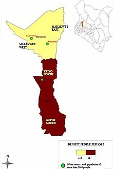
Administrative and Political Units[]
Elgeyo - Marakwet is divided into 4 sub-counties, 20 county assemblies wards, 68 locations and 199 sub-locations. Below is the distribution of the county assemblies wards.
| Constituency | No. of Wards |
|---|---|
| Marakwet East | 4 |
| Marakwet West | 6 |
| Keiyo North | 4 |
| Keiyo South | 6 |
| TOTAL | 20 |
Source[7]
County government[]
As of 2015, the County Governor was Alex Tolgos,[8] the Senator was Onesmus Kipchumba Murkomen,[9] and County Women Representative was ,[10] all of the United Republican Party, an affiliate of the Jubilee Alliance. The county has four constituencies in the National Assembly, and twenty ward seats in its County Assembly. The Speaker was Albert Kochei.

Elgeyo Marakwet Governor Alex Tolgos

Elgeyo Marakwet senator Onesmus Kipchumba Murkomen

Elgeyo Marakwet Women Representative Susan Kipketer Chebet


County Executive Committee[]
| Person | Docket |
|---|---|
| Edwin Kisang | Education and Technical Training |
| Shadrack Yatich | Trade, Co-operatives, Energy and Tourism |
| Kevin Biwott[11] | Public Works and Transport |
| Anita Kimwattan | Health Services |
| Abraham Barsosio | Water, Physical Planning and Natural Resources |
| Dr.Kiprono Chepkok | Youth, Sports, Women and Social Services |
| Anne Kibosia | Agriculture,Livestock and Fisheries |
Source [12]
County Ward Representatives[]
| Constituency | Ward | Representative |
|---|---|---|
| Marakwet East | Kapyego | Kiptire Benson Kibet |
| Marakwet East | Sambirir | Suter Paul Kipkemoi |
| Marakwet East | Endo | Kirop Festus Korir |
| Marakwet East | Embobut/Embulot | Chebii Simion |
| Marakwet West | Lelan | Priscilla Kurgat |
| Marakwet West | Sengwer | Kiprono Kipketer David |
| Marakwet West | Cherang'any/Chebororwa | Koech Philemon Kiptoo |
| Marakwet West | Moiben/Kuserwo | Chesingany William Cheruiyot |
| Marakwet West | Kapsowar | Yego David |
| Marakwet West | Arror | Christopher Kibor Kimutai |
| Keiyo North | Kamariny | Lagat Kenneth Kibet |
| Keiyo North | Emsoo | Cheboiboch Christopher Kangogo |
| Keiyo North | Tambach | Keitany Vincent Kiptoo |
| Keiyo North | Kapchemutwa | Cherop Rosa |
| Keiyo South | Kaptarakwa | Kigen Thomas Kipkorir |
| Keiyo South | Chepkorio | Kibet Tecla Jerotich |
| Keiyo South | Soy North | Kipchumba Vincent Kipruto |
| Keiyo South | Soy South | Cheruiyot Gilbert Kaptugen |
| Keiyo South | Kabiemit | Boit Wilson Kipketer |
| Keiyo South | Metkei | Chirchir Daniel |
| Nominated | Kaptarakwa | Rael Jepiwott Limo |
| Nominated | ||
| Nominated | ||
| Nominated | ||
| Nominated |
Health[]
There are a total of 129 health facilities in the county with an averages of 3.7 km access distance from one health centre to another.[15] The county has 626 medical personnel cutting across different of medical profession.[16][17]
Transport and Communication[]
The is covered with 292.1 km of earth, 1,415.3 km of murram and 92.2 km of bitumen.[when?][18][19] As at 2014 there were 8 postal offices across the county with 1,600 installed letter boxes, 1,112 rented letter boxes and 488 vacant letter boxes.[20]
Economy[]
Economic activity in the county is characterized by mixed farming, which consists mainly of livestock and subsistence farming. Other activities include small business, tourism and fluorspar mining in Kerio Valley. Oil Prospecting by Tullow Oil Company is ongoing in Kerio Valley.[21]
As at 2014 county had 62,190,000 cattle, 7,220,000 goats and 10,232,000 sheep.[22]
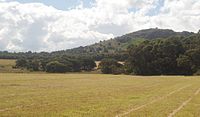
Tourism[]
Major Tourist Attractions are
- Kerio Valley National Reserve
- Elgeyo Escarpment
- Sports Tourism
- Paragliding
- Cherang'any Hills
- River Kerio
- Rimoi National Reserve
- Chebara Dam
- Sergoit Hill
- Lake Kapnarok
- Cheploch Gorge
- Kipteber Meteorite Historical Mountain
- Kureswo Hotsprings

Kerio river

Cheploch gorge

Elgeyo escapment

Elgeyo marakwet valley

Torok waterfall
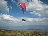
Paragliding in Kerio Escarpment near Iten.

Rimoi National Park
Sergoit hill


Education systems[]
There are a total of 554 ECD centres, 418 primary schools and 112 secondary schools in the county.
| Category | No. of Public | No. of Private | Total |
|---|---|---|---|
| ECD Centres | 427 | 127 | 554 |
| Primary Schools | 367 | 51 | 418 |
| Secondary Schools | 111 | 1 | 113 |
| Indicator | Statistics |
|---|---|
| Number of Institutions (2007) | Primary (373), Secondary (75) |
| Primary | Enrolment (110,399) |
| Teacher to Pupil Ratio | 1: 36 (Public Schools) |
| Secondary | Enrolment (20,887) |
| Teacher to Pupil Ratio | 1:30 (Public Schools) |
| Tertiary | 1 Teacher Training College, 3 Vocational Training Centers |
| Adult Literacy Classes | Enrolment (Data Not available) |
Notable Secondary Schools
|
Health[]
| Indicator | Statistics |
|---|---|
| Health Facilities: | 113 - Referral Hospitals (1),District Hospital (1), Sub-District Hospitals (5), Dispensaries (89), Health Centres (15), Medical Clinics (1), Others (1) |
| Doctor to Population Ratio: | 1:50,000 (Marakwet), 1:156,471 (Keiyo) |
| Infant Mortality Rates: | 57/1000 (Keiyo) |
| Under Five Mortality Rates: | 9.7/1000 (Keiyo) |
| Prevalent Diseases: | Malaria, Diarrhoea, Bronchopneumonia and respiratory tract infections, urinary tract infections |
| Notable Hospitals: |
|
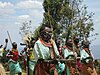
Sports[]
Major sports activity[]
The county is notable for its long-standing tradition of producing top athletes who have represented Kenya in many international athletics events.

Notable sport personalities[]
Notable Athletes hailing from this county include;
- Sally Barsosio
- Richard Chelimo
- Abraham Cherono
- Vivian Cheruiyot
- Ezekiel Kemboi
- Viola Kibiwot
- Hilda Kibet
- Edna Ngeringwony Kiplagat
- Lornah Kiplagat
- Brimin Kipruto
- Wilson Kipsang Kiprotich
- Moses Kiptanui
- Frankline Ngelel
- Evans Ruto
Important towns[]
EMC Towns
- Arror
- Chebiemit
- Chebororwa
- Chepkorio
- Cheptongei
- Chesoi
- Chesongoch
- Chugor
- Flax
- Iten
- Kapchebau
- Kapcherop
- Kapkoi
- Kapsait
- Kapsowar
- Kaptalamwa
- Kaptarakwa
- Kapteren
- Kapyego[25]
- Katumoi
- Kipmwarer
- Kocholwo
- Kondabilet
- Tenden
- Tot
- Kabulwo
- kangoo
- Tambach
Eminent people[]
| List | Achievements | |||
|---|---|---|---|---|
| The late Nicholas Biwott | Former Powerful Cabinet Minister in Government of President Daniel Toroitich arap Moi. Also known as 'TOTAL MAN aka KARNET' | |||
| Kipchumba Murkomen | Elgeyo Marakwet County Senator 2013 to date | First deputy Majority leader of the Kenyan Senate
2nd Majority Leader of the |
||
| Former MD and former aspirant Governatorial candidate Elgeyo Marakwet County | ||||
| Julius Kipngetich | Former CEO of Kenya Wildlife Service, Formerly Equity Bank Kenya Chief Operations Officer and Currently Uchumi Supermarkets CEO | |||
| Philip Kiptoo Tunoi | Judge of Supreme Court of Kenya between 2012 - to Date | |||
| Philip Kipchirchir Murgor | lawyer and Former Director of Public Prosecution | |||
| Brother Colm O'Connell | Irish missionary and retired teacher. Successful Athletics Coach | |||
| Gladys Boss Shollei | Former Chief Registrar of Kenya Judiciary, Current Woman Representative candidate Uasin Gishu County | |||
| William Chebor Murgor | a member of pre-independence legislative council-Legco, and former MP of Keiyo North | |||
| Lieutenant General Lazaro Kipkurui Sumbeiywo | Former Commandant of the Defence Staff College and Army Commander. Kenya special envoy to the Sudan and south Sudan peace process | Joseph Kipchirchir Boinnet- Immeadiate Former Inspector General of the National Police Service | ||
| Sub-County/Constituency | Wards |
|---|---|
| Marakwet East | Kapyego · Sambirir · Endo · Embobut/Embulot |
| Marakwet West | Lelan · Sengwer · Cherang'any/Chebororwa · Moiben/Kuserwo · Kapsowar · Arror |
| Keiyo North | Kamariny · Emsoo · Tambach · Kapchemutwa |
| Keiyo South | Kaptarakwa · Chepkorio · Soy North · Soy South · Kabiemit · Metkei |
Services and urbanisation[]
| County | Stats for the County (Percent)
|
|---|---|
| Urbanisation | 14.4
|
| Literacy | 77.6
|
| Attending School (15-18 Yrs) | 84.8
|
| Paved Roads | 5.7
|
| Good Roads | 50.8
|
| Electricity Access | 7.2
|
| Poverty Rate | 55.5
|
See also[]
- Kabarak
- West Pokot County
- Baringo County
- Uasin Gishu County
- Trans Nzoia County
References[]
- ^ "Kenya Census 2009". Retrieved 22 July 2014 – via Scribd.
- ^ Munene, Evans (4 November 2019). "2019 Kenya Population and Housing Census Results". Kenya National Bureau of Statistics. Retrieved 26 May 2020.
- ^ Jones, W. B (1 January 1988). "Listric growth faults in the Kenya Rift Valley". Journal of Structural Geology. 10 (7): 661–672. Bibcode:1988JSG....10..661J. doi:10.1016/0191-8141(88)90074-0. ISSN 0191-8141.
- ^ "Moroto | Uganda". Encyclopedia Britannica. Retrieved 27 May 2020.
- ^ "Attraction - iSafiri". isafiri.com. Retrieved 27 May 2020.
- ^ "History – Uasin Gishu County". Retrieved 27 May 2020.
- ^ IEBC. "The Report of the Interim Independent Boundaries Review Commission (IIBRC): Delimitation of Constituencies and Recommendations on Local Authority Electoral Units and Administrative Boundaries for Districts and Other Units" (PDF). Retrieved 26 May 2020.
- ^ "Governors & Deputy Governors". cog.go.ke. Retrieved 26 May 2020.
- ^ "Members of the Senate | The Kenyan Parliament Website". www.parliament.go.ke. Retrieved 26 May 2020.
- ^ "Women Representatives | KEWOPA KENYA". Retrieved 26 May 2020.
- ^ https://elgeyomarakwet.go.ke/governance/
- ^ "Governance". Elgeyo Marakwet County. Retrieved 26 May 2020.
- ^ "SUMMARY OF RESULTS FOR MEMBER OF COUNTY ASSEMBLY WARD REPRESENTATIVE. [MARCH 4TH 2013 - GENERAL ELECTION&*93;". Iebc.or.ke. Retrieved 22 July 2014.
- ^ "Members Nominated To County Assembly Wards". Iebc.or.ke. 18 July 2013. Retrieved 22 July 2014.
- ^ Siele, Linus. "County health facilities increase to 129 as access to healthcare reduced to 3.7 km". Elgeyo Marakwet County. Retrieved 26 May 2020.
- ^ "Health Services & Sanitation". Elgeyo Marakwet County. Retrieved 26 May 2020.
- ^ "Publications". Kenya National Bureau of Statistics. Retrieved 26 May 2020.
- ^ "Home". www.kerra.go.ke. Retrieved 26 May 2020.
- ^ "Roads, Public Works & Transport". Elgeyo Marakwet County. Retrieved 26 May 2020.
- ^ Jump up to: a b Kenya National Bureau of Statistics (2015). County Statistical Abstract Elgeyo Marakwet 2015. Kenya National Bureau of Statistics. p. 18.
- ^ "Tullow hopeful of Kenya FID this year". www.petroleum-economist.com. Retrieved 27 May 2020.
- ^ "Livestock Development, Cooperatives & Fisheries". Elgeyo Marakwet County. Retrieved 26 May 2020.
- ^ "Education and Technical Training". Elgeyo Marakwet County. Retrieved 26 May 2020.
- ^ Jump up to: a b "Elgeyo Marakwet". Crakenya.org. Retrieved 22 July 2014.
- ^ Chebororwa
- ^ USAid Kenya Archived 23 February 2013 at the Wayback Machine
External links[]

- Elgeyo-Marakwet County
- Counties of Kenya