Elk Rapids, Michigan
Elk Rapids, Michigan | |
|---|---|
| Village of Elk Rapids | |
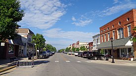 Downtown Elk Rapids on River Street | |
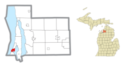 Location within Antrim County | |
 Elk Rapids Location within the state of Michigan | |
| Coordinates: 44°53′49″N 85°24′38″W / 44.89694°N 85.41056°W | |
| Country | United States |
| State | Michigan |
| County | Antrim |
| Township | Elk Rapids |
| Platted | 1852 |
| Incorporated | 1900 |
| Government | |
| • Type | Village council |
| • President | James Janisse |
| • Clerk | Caroline Kennedy |
| Area | |
| • Total | 2.01 sq mi (5.20 km2) |
| • Land | 1.65 sq mi (4.27 km2) |
| • Water | 0.36 sq mi (0.93 km2) |
| Elevation | 597 ft (182 m) |
| Population | |
| • Total | 1,642 |
| • Estimate (2019)[5] | 1,615 |
| • Density | 978.79/sq mi (377.86/km2) |
| Time zone | UTC-5 (Eastern (EST)) |
| • Summer (DST) | UTC-4 (EDT) |
| ZIP code(s) | 49629 |
| Area code(s) | 231 |
| FIPS code | 26-25320[3] |
| GNIS feature ID | 0625459[4] |
| Website | Official website |

Elk Rapids is a village in Antrim County in the state of Michigan. The population was 1,642 at the 2010 census. The village is located within Elk Rapids Township, about 15 miles (24 km) north of Traverse City. It is physically split by the Elk River, which runs between nearby Elk Lake and Grand Traverse Bay.
History[]

Elk Rapids began as a small port on the Grand Traverse Bay in the 1840s. It was platted in 1852 with the name of Stevens.[6] Because of its location, the town quickly became a major resort center, which highly contributed to its growth during the period. In the 1870s, the began on the east side of the town. Within 30 years of the Iron Works' founding, Elk Rapids had become the county seat of Antrim County (which Bellaire took from Elk Rapids in 1880). The town also boasted a cement plant, a chemical plant, a depot on the Chicago and West Michigan Railroad, and a population of nearly 2000. It was incorporated as a village in 1900.
Through the 1890s-1910s, the town was a thriving commercial center with many shops and hotels lining River Street (Elk Rapids' main street). This "heyday" did not last long; the Iron Works and all the other industrial operations had ceased by 1916, leaving the town economically depressed. Elk Rapids remained this way until the 1950s, when the town experienced a boom in tourism due to its location on the then newly rerouted US 31.[disputed ]
Geography[]
According to the United States Census Bureau, the village has a total area of 2.01 square miles (5.21 km2), of which, 1.65 square miles (4.27 km2) of it is land and 0.36 square miles (0.93 km2) is water.[7]
Demographics[]
| Historical population | |||
|---|---|---|---|
| Census | Pop. | %± | |
| 1880 | 620 | — | |
| 1910 | 1,673 | — | |
| 1920 | 684 | −59.1% | |
| 1930 | 615 | −10.1% | |
| 1940 | 690 | 12.2% | |
| 1950 | 889 | 28.8% | |
| 1960 | 1,015 | 14.2% | |
| 1970 | 1,249 | 23.1% | |
| 1980 | 1,504 | 20.4% | |
| 1990 | 1,626 | 8.1% | |
| 2000 | 1,700 | 4.6% | |
| 2010 | 1,642 | −3.4% | |
| 2019 (est.) | 1,615 | [5] | −1.6% |
| U.S. Decennial Census[8] | |||

2010 census[]
As of the census[2] of 2010, there were 1,642 people, 791 households, and 478 families residing in the village. The population density was 995.2 inhabitants per square mile (384.2/km2). There were 1,179 housing units at an average density of 714.5 per square mile (275.9/km2). The racial makeup of the village was 96.6% White, 0.7% African American, 1.2% Native American, 0.5% Asian, 0.1% Pacific Islander, 0.2% from other races, and 0.7% from two or more races. Hispanic or Latino of any race were 1.3% of the population.
There were 791 households, of which 21.0% had children under the age of 18 living with them, 48.4% were married couples living together, 9.6% had a female householder with no husband present, 2.4% had a male householder with no wife present, and 39.6% were non-families. 34.8% of all households were made up of individuals, and 17.9% had someone living alone who was 65 years of age or older. The average household size was 2.07 and the average family size was 2.63.
The median age in the village was 52.4 years. 18.6% of residents were under the age of 18; 5.6% were between the ages of 18 and 24; 16.3% were from 25 to 44; 30.9% were from 45 to 64; and 28.7% were 65 years of age or older. The gender makeup of the village was 46.5% male and 53.5% female.
2000 census[]
As of the census[3] of 2000, there were 1,700 people, 769 households, and 483 families residing in the village. The population density was 1,014.3 per square mile (390.7/km2). There were 1,056 housing units at an average density of 630.1 per square mile (242.7/km2). The racial makeup of the village was 97.00% White, 0.29% African American, 1.00% Native American, 0.12% Asian, 0.24% Pacific Islander, 0.59% from other races, and 0.76% from two or more races. Hispanic or Latino of any race were 2.12% of the population.
There were 769 households, out of which 27.8% had children under the age of 18 living with them, 49.7% were married couples living together, 10.8% had a female householder with no husband present, and 37.1% were non-families. 34.6% of all households were made up of individuals, and 17.3% had someone living alone who was 65 years of age or older. The average household size was 2.20 and the average family size was 2.83.
In the village, the population was spread out, with 24.2% under the age of 18, 5.1% from 18 to 24, 23.2% from 25 to 44, 27.5% from 45 to 64, and 19.9% who were 65 years of age or older. The median age was 43 years. For every 100 females, there were 94.5 males. For every 100 females age 18 and over, there were 83.2 males.
The median income for a household in the village was $31,382, and the median income for a family was $45,179. Males had a median income of $30,845 versus $23,167 for females. The per capita income for the village was $19,735. About 7.6% of families and 8.2% of the population were below the poverty line, including 11.1% of those under age 18 and 5.8% of those age 65 or over.
Major highways[]
Images[]
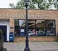
Post office

Looking north at the city sign

City welcome sign
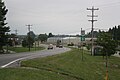
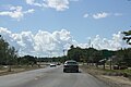
Looking north on US 31
Sign on US 31
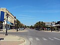
Downtown Elk Rapids on River Street


References[]
- ^ "2019 U.S. Gazetteer Files". United States Census Bureau. Retrieved July 25, 2020.
- ^ Jump up to: a b "U.S. Census website". United States Census Bureau. Retrieved 2012-11-25.
- ^ Jump up to: a b "U.S. Census website". United States Census Bureau. Retrieved 2008-01-31.
- ^ "US Board on Geographic Names". United States Geological Survey. 2007-10-25. Retrieved 2008-01-31.
- ^ Jump up to: a b "Population and Housing Unit Estimates". United States Census Bureau. May 24, 2020. Retrieved May 27, 2020.
- ^ Walter Romig, Michigan Place Names, p. 179
- ^ "US Gazetteer files 2010". United States Census Bureau. Archived from the original on 2012-01-25. Retrieved 2012-11-25.
- ^ "Census of Population and Housing". Census.gov. Retrieved June 4, 2015.
External links[]
| Wikimedia Commons has media related to Elk Rapids, Michigan. |
- Historic Elk Rapids Town Hall Association
- Village of Elk Rapids, MI
- Township of Elk Rapids, MI
- Elk Rapids Public Schools
- The Elk Rapids Area Chamber of Commerce
| show Municipalities and communities of Antrim County, Michigan, United States |
|---|

| show Authority control |
|---|
- Villages in Antrim County, Michigan
- Villages in Michigan
- 1900 establishments in Michigan
- Populated places established in 1900
- Michigan populated places on Lake Michigan