Elkhart, Kansas
Elkhart, Kansas | |
|---|---|
City and County seat | |
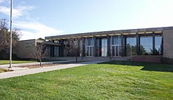 Morton County Court House (2009) | |
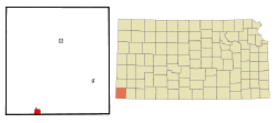 Location within Morton County and Kansas | |
 | |
| Coordinates: 37°0′11″N 101°53′53″W / 37.00306°N 101.89806°WCoordinates: 37°0′11″N 101°53′53″W / 37.00306°N 101.89806°W | |
| Country | United States |
| State | Kansas |
| County | Morton |
| Founded | 1913 |
| Incorporated | 1913 |
| Named for | Elkhart, Indiana |
| Area | |
| • Total | 2.05 sq mi (5.32 km2) |
| • Land | 2.05 sq mi (5.32 km2) |
| • Water | 0.00 sq mi (0.00 km2) |
| Elevation | 3,589 ft (1,094 m) |
| Population | |
| • Total | 2,205 |
| • Estimate (2019)[3] | 1,758 |
| • Density | 855.89/sq mi (330.53/km2) |
| Time zone | UTC−6 (CST) |
| • Summer (DST) | UTC−5 (CDT) |
| ZIP code | 67950 |
| Area code | 620 |
| FIPS code | 20-20350 [4] |
| GNIS ID | 485090 [5] |
| Website | City website |

Elkhart is a city in and the county seat of Morton County, Kansas, United States.[6] The south edge of the city is the Kansas-Oklahoma state border, and the city is 8.5 miles (13.7 km) from the Kansas-Colorado border. As of the 2010 census, the city population was 2,205.[7]
History[]

Elkhart was founded in 1913,[8] and was named after Elkhart, Indiana.[9]
Elkhart was the starting point of the Elkhart and Santa Fe Railway.[10] This line, both leased to and a wholly owned subsidiary of the Atchison, Topeka and Santa Fe Railway,[11] was built in 1925 to Felt, Oklahoma, and extended into New Mexico in 1932; but, was abandoned in 1942.[12]
In 1961, the county seat was moved from Richfield to Elkhart.[13]
Geography[]
According to the United States Census Bureau, the city has a total area of 2.11 square miles (5.46 km2), all of it land.[14]
Climate[]
Elkhart has a cool semi-arid climate (Köppen BSk) characterized by generally dry winters with extreme temperature variations, and hot summers with occasional heavy precipitation from thunder showers or storms.
During winter, because western Kansas lies both on the edge of the subtropical anticyclones and in the rain shadow of westerly winds crossing the Rocky Mountains, the region is generally dry: no measurable precipitation fell in Elkhart between 25 December 1903 and 2 April 1904, while monthly precipitation above 2 inches or 50.8 millimetres has never been recorded during January and is observed fewer than one year in ten during November, December or February. Temperatures can vary greatly during this season: strong chinook winds can drive temperatures above 80 °F or 26.7 °C even in the depth of winter, with 70 °F or 21.1 °C reached on average during six days between December and February, seven during November and eight during March. Nevertheless, cold outbreaks from Canada drive temperatures to or below 0 °F or −17.8 °C on an average of 3.6 nights per winter. The coldest temperature recorded in Elkhart has been −22 °F or −30 °C on January 19, 1984, while the hottest winter temperature has been 87 °F or 30.6 °C on February 1, 1963.
Snowfall is generally light due to dryness; however in the extremely wet and cold February 1903, 41.0 inches or 1.04 metres fell, being the major factor behind a record seasonal snowfall of 59.0 inches (1.50 m) between July 1902 and June 1903. In contrast, only a trace of snow was recorded between July 1949 and January 1950.
In the summer, the climate is generally very hot with relief from thunderstorms that provide most of the 18.9 inches or 480 millimetres of precipitation expected during one year. When an upper level anticyclone moves poleward, the atmosphere can become very stable and produce sustained extreme heat: in the hottest month of July 1980 the average maximum was 103.0 °F or 39.4 °C and all but seven days topped 100 °F or 37.8 °C. When the high retreats southward or a trough forms over the interior of the United States during the summer, however, precipitation can be heavy, with 10.91 inches or 277.1 millimetres falling in April 2016, 10.19 inches or 258.8 millimetres in June 2004 and 9.86 inches or 250.4 millimetres in July 1927. The wettest calendar year has been 1941 with 29.74 inches or 755.4 millimetres and the driest 1937 when only 9.03 inches or 229.4 millimetres fell.
| hideClimate data for Elkhart, Kansas (1971-2000; extremes since 1900) | |||||||||||||
|---|---|---|---|---|---|---|---|---|---|---|---|---|---|
| Month | Jan | Feb | Mar | Apr | May | Jun | Jul | Aug | Sep | Oct | Nov | Dec | Year |
| Record high °F (°C) | 83 (28) |
87 (31) |
91 (33) |
96 (36) |
104 (40) |
110 (43) |
110 (43) |
108 (42) |
105 (41) |
96 (36) |
91 (33) |
85 (29) |
110 (43) |
| Average high °F (°C) | 45.1 (7.3) |
50.6 (10.3) |
58.6 (14.8) |
68.1 (20.1) |
77.8 (25.4) |
88.9 (31.6) |
93.4 (34.1) |
90.9 (32.7) |
82.3 (27.9) |
71.6 (22.0) |
56.3 (13.5) |
46.9 (8.3) |
69.2 (20.7) |
| Average low °F (°C) | 18.3 (−7.6) |
22.2 (−5.4) |
29.9 (−1.2) |
38.9 (3.8) |
49.0 (9.4) |
58.9 (14.9) |
64.2 (17.9) |
62.7 (17.1) |
54.0 (12.2) |
41.1 (5.1) |
28.9 (−1.7) |
20.6 (−6.3) |
40.7 (4.8) |
| Record low °F (°C) | −22 (−30) |
−18 (−28) |
−18 (−28) |
8 (−13) |
21 (−6) |
33 (1) |
45 (7) |
43 (6) |
25 (−4) |
6 (−14) |
−7 (−22) |
−18 (−28) |
−22 (−30) |
| Average precipitation inches (mm) | 0.54 (14) |
0.44 (11) |
1.38 (35) |
1.67 (42) |
2.75 (70) |
2.50 (64) |
2.82 (72) |
2.74 (70) |
1.69 (43) |
1.11 (28) |
0.78 (20) |
0.48 (12) |
18.9 (481) |
| Average snowfall inches (cm) | 5.5 (14) |
4.4 (11) |
4.9 (12) |
1.2 (3.0) |
0.2 (0.51) |
0.0 (0.0) |
0.0 (0.0) |
0.0 (0.0) |
0.1 (0.25) |
1.0 (2.5) |
1.6 (4.1) |
3.4 (8.6) |
22.3 (55.96) |
| Average precipitation days (≥ 0.01 inch) | 3.3 | 3.1 | 5.2 | 5.4 | 7.8 | 7.4 | 7.3 | 6.9 | 5.2 | 3.7 | 3.6 | 3.1 | 62 |
| Average snowy days (≥ 0.1 inch) | 2.3 | 2.0 | 1.5 | 0.4 | trace | 0.0 | 0.0 | 0.0 | trace | 0.2 | 1.0 | 1.9 | 9.3 |
| Source 1: National Oceanic and Atmospheric Administriation[15] | |||||||||||||
| Source 2: National Weather Service Dodge City[16] | |||||||||||||
Demographics[]
| Historical population | |||
|---|---|---|---|
| Census | Pop. | %± | |
| 1920 | 1,160 | — | |
| 1930 | 1,485 | 28.0% | |
| 1940 | 902 | −39.3% | |
| 1950 | 1,132 | 25.5% | |
| 1960 | 1,780 | 57.2% | |
| 1970 | 2,089 | 17.4% | |
| 1980 | 2,243 | 7.4% | |
| 1990 | 2,318 | 3.3% | |
| 2000 | 2,233 | −3.7% | |
| 2010 | 2,205 | −1.3% | |
| 2019 (est.) | 1,758 | [3] | −20.3% |
| U.S. Decennial Census | |||
2010 census[]
As of the census[2] of 2010, there were 2,205 people, 856 households, and 571 families residing in the city. The population density was 1,045.0 inhabitants per square mile (403.5/km2). There were 999 housing units at an average density of 473.5 per square mile (182.8/km2). The racial makeup of the city was 87.7% White, 0.1% African American, 1.2% Native American, 2.5% Asian, 6.8% from other races, and 1.6% from two or more races. Hispanic or Latino of any race were 20.7% of the population.
There were 856 households, of which 33.8% had children under the age of 18 living with them, 52.9% were married couples living together, 9.1% had a female householder with no husband present, 4.7% had a male householder with no wife present, and 33.3% were non-families. 29.2% of all households were made up of individuals, and 14.6% had someone living alone who was 65 years of age or older. The average household size was 2.48 and the average family size was 3.07.
The median age in the city was 38.4 years. 26.4% of residents were under the age of 18; 7.6% were between the ages of 18 and 24; 23% were from 25 to 44; 25.6% were from 45 to 64; and 17.6% were 65 years of age or older. The gender makeup of the city was 47.7% male and 52.3% female.
2000 census[]
As of the census[4] of 2000, there were 2,233 people, 854 households, and 610 families residing in the city. The population density was 1,205.0 people per square mile (466.0/km2). There were 977 housing units at an average density of 527.2 per square mile (203.9/km2). The racial makeup of the city was 89.34% White, 0.09% African American, 1.16% Native American, 1.25% Asian, 6.63% from other races, and 1.52% from two or more races. Hispanic or Latino of any race were 13.39% of the population.
There were 854 households, out of which 36.2% had children under the age of 18 living with them, 61.9% were married couples living together, 7.4% had a female householder with no husband present, and 28.5% were non-families. 26.1% of all households were made up of individuals, and 10.4% had someone living alone who was 65 years of age or older. The average household size was 2.55 and the average family size was 3.08.
In the city, the population was spread out, with 28.0% under the age of 18, 9.0% from 18 to 24, 27.4% from 25 to 44, 20.8% from 45 to 64, and 14.8% who were 65 years of age or older. The median age was 36 years. For every 100 females, there were 91.8 males. For every 100 females age 18 and over, there were 88.2 males.
The median income for a household in the city was $37,333, and the median income for a family was $43,548. Males had a median income of $33,333 versus $19,792 for females. The per capita income for the city was $17,900. About 7.3% of families and 9.3% of the population were below the poverty line, including 13.8% of those under age 18 and 4.7% of those age 65 or over.
Education[]
Elkhart is served by USD 218 Elkhart. The Elkhart High School mascot is Wildcats.[17]
Area attractions[]
Elkhart is home to multiple locations relevant to the Santa Fe Trail, including
- Point of Rocks--Middle Spring Santa Fe Trail Historic District, 2.5 miles (4.0 km) south of K-51 and 2 miles (3.2 km) west of K-27
- Santa Fe Trail--Cimarron National Grassland Segment 1, 2.0 miles (3.2 km) south of K-51 at the Colorado–Kansas state line
- Santa Fe Trail--Cimarron National Grassland Segment 2, 1.66 miles (2.67 km) south of K-51 and 1 mile (1.6 km) east of County Road 2
- Santa Fe Trail--Cimarron National Grassland Segment 3, FSR-600, east and west sides of k-27
- Santa Fe Trail--Cimarron National Grassland Segment 4, 2.5 miles (4.0 km) east of K-27, north of FSR-600
Notable people[]
Elkhart is the birthplace of two Olympic athletes:
- Sanora Babb, American writer, came at the age of 11 to attend school for the first time in 1918 with her parents and sister from a farm near the town of Artesia, Baca County, Colorado, following an attempt at homesteading in Lamar, Colorado, as described in her 1970 fictionalized memoir An Owl on Every Post.
- Walter Baker, winner of Olympic medals at the 1952 Summer Olympics and 1956 Summer Olympics.
- Glenn Cunningham, nicknamed the "Elkhart Express", former world record-holder in the mile run and silver medalist in the 1500 meter run at the 1936 Summer Olympics.
- Robelyn Garcia, Professional Women's Basketball Association (WBA) 4X All-Star and WBA Championship MVP. Collegiate All-American basketball player and College Athletic Hall Of Fame Inductee.
- Darrin Simmons, Cincinnati Bengals special teams coach.
See also[]
References[]
- ^ "2019 U.S. Gazetteer Files". United States Census Bureau. Retrieved July 24, 2020.
- ^ Jump up to: a b "U.S. Census website". United States Census Bureau. Retrieved 2012-07-06.
- ^ Jump up to: a b "Population and Housing Unit Estimates". United States Census Bureau. May 24, 2020. Retrieved May 27, 2020.
- ^ Jump up to: a b "U.S. Census website". United States Census Bureau. Retrieved 2008-01-31.
- ^ "US Board on Geographic Names". United States Geological Survey. 2007-10-25. Retrieved 2008-01-31.
- ^ "Find a County". National Association of Counties. Archived from the original on 2011-05-31. Retrieved 2011-06-07.
- ^ "2010 City Population and Housing Occupancy Status". U.S. Census Bureau. Retrieved March 27, 2011.[dead link]
- ^ Kansas State Historical Society (1916). Biennial Report of the Board of Directors of the Kansas State Historical Society. Kansas State Printing Plant. pp. 248.
- ^ "Profile for Elkhart, Kansas". ePodunk. Retrieved 16 June 2014.
- ^ "Texas County". Dianna Everett, Oklahoma Historical Society. Retrieved September 9, 2020.
- ^ Railroads of Oklahoma, June 6, 1870 to April 1, 1978. State of Oklahoma Department of Transportation, Survey Division. April 1, 1978. p. 37.
- ^ "Cimarron County". Norma Gene Young, Oklahoma Historical Society. Retrieved September 9, 2020.
- ^ Morton County Facts; mtcoks.com
- ^ "US Gazetteer files 2010". United States Census Bureau. Archived from the original on 2012-01-25. Retrieved 2012-07-06.
- ^ "Climatography of the United States No. 20: 1971-2000 – Elkhart, KS" (PDF). Retrieved September 29, 2016.
- ^ "NOW Data". Retrieved September 29, 2016.
- ^ "Elkhart USD 218". USD 218. Retrieved 8 January 2017.
Further reading[]
External links[]
| Wikimedia Commons has media related to Elkhart, Kansas. |
- City of Elkhart
- Elkhart - Directory of Public Officials
- USD 218, local school district
- Morton County Historical Society Museum
- Elkhart City Map, KDOT
| hide Municipalities and communities of Morton County, Kansas, United States | ||
|---|---|---|
| Cities |  | |
| Unincorporated community | ||
| ||
| show Authority control |
|---|
- Cities in Kansas
- County seats in Kansas
- Cities in Morton County, Kansas
- 1913 establishments in Kansas