Ellingsrudåsen station
 | |
| General information | |
| Location | Ellingsrud, Oslo Norway |
| Coordinates | 59°56′9″N 10°54′59″E / 59.93583°N 10.91639°ECoordinates: 59°56′9″N 10°54′59″E / 59.93583°N 10.91639°E |
| Elevation | 165.2 m (542 ft) |
| Owned by | Sporveien |
| Operated by | Sporveien T-banen |
| Line(s) | Furuset Line |
| Distance | 12.0 km (7.5 mi) from Stortinget |
| Connections | Bus: 33 Filipstad via Carl Berners plass 2N Østerås T - Helsfyr T - Lørenskog Sentrum (Nattbuss) |
| Construction | |
| Structure type | Underground |
| Disabled access | Yes |
| History | |
| Opened | 8 November 1981 |
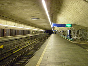
Ellingsrudåsen is a subway station on the Oslo Metro, located at Ellingsrud in the Alna borough. Since its opening on 8 November 1981, it has been the end station for the Furuset Line (Line 2). Ellingsrudåsen is a mostly residential area. Above the station is a small shopping centre.
Ellingsrudåsen is located deep underground, and elevators are the usual means of getting to and from the station. Like Romsås, Ellingsrudåsen has natural mountain walls.
| TERMINUS | NEXT STATION ← WEST |
Ellingsrudåsen | NEXT STATION EAST → |
TERMINUS | ||
|---|---|---|---|---|---|---|
| Østerås | Furuset | Line 2 | Terminus | Ellingsrudåsen | ||
References[]
This article does not cite any sources. (December 2009) |
External links[]
![]() Media related to Ellingsrudåsen stasjon at Wikimedia Commons
Media related to Ellingsrudåsen stasjon at Wikimedia Commons
Line 2[]
| Line 2: Østerås – Stortinget – Ellingsrudåsen | |
|
Østerås • Lijordet • Eiksmarka • Ekraveien • Røa • Hovseter • Holmen • Makrellbekken • Smestad • Borgen • Majorstuen • Nationaltheatret • Stortinget • Jernbanetorget • Grønland • Tøyen • Ensjø • Helsfyr • Brynseng • Hellerud • Tveita • Haugerud • Trosterud • Lindeberg • Furuset • Ellingsrudåsen | |
- Oslo Metro stations in Oslo
- Railway stations opened in 1981
- Oslo Metro stations located underground
- 1981 establishments in Norway
- Oslo Metro stubs
