Erbajolo
show This article may be expanded with text translated from the corresponding article in French. (December 2008) Click [show] for important translation instructions. |
Erbajolo | |
|---|---|
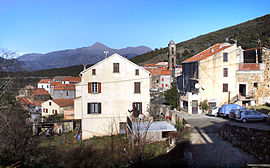 A general view of Erbajolo | |
show Location of Erbajolo | |
 Erbajolo | |
| Coordinates: 42°15′54″N 9°17′02″E / 42.265°N 9.2839°ECoordinates: 42°15′54″N 9°17′02″E / 42.265°N 9.2839°E | |
| Country | France |
| Region | Corsica |
| Department | Haute-Corse |
| Arrondissement | Corte |
| Canton | Golo-Morosaglia |
| Government | |
| • Mayor (2020–2026) | Mathieu Mariani[1] |
| Area 1 | 15.45 km2 (5.97 sq mi) |
| Population (Jan. 2018)[2] | 113 |
| • Density | 7.3/km2 (19/sq mi) |
| Time zone | UTC+01:00 (CET) |
| • Summer (DST) | UTC+02:00 (CEST) |
| INSEE/Postal code | 2B105 /20212 |
| Elevation | 180–924 m (591–3,031 ft) (avg. 750 m or 2,460 ft) |
| 1 French Land Register data, which excludes lakes, ponds, glaciers > 1 km2 (0.386 sq mi or 247 acres) and river estuaries. | |


Erbajolo is a commune in the Haute-Corse department of France on the island of Corsica.
Population[]
| Year | Pop. | ±% |
|---|---|---|
| 1962 | 102 | — |
| 1968 | 132 | +29.4% |
| 1975 | 137 | +3.8% |
| 1982 | 101 | −26.3% |
| 1990 | 90 | −10.9% |
| 1999 | 92 | +2.2% |
| 2006 | 106 | +15.2% |
| 2011 | 103 | −2.8% |
| 2015 | 107 | +3.9% |
Monuments[]
See also[]
- Communes of the Haute-Corse department
References[]
- ^ "Répertoire national des élus: les maires". data.gouv.fr, Plateforme ouverte des données publiques françaises (in French). 2 December 2020.
- ^ "Populations légales 2018". INSEE. 28 December 2020.
| Wikimedia Commons has media related to Erbajolo. |
| show Communes of the Haute-Corse department |
|---|
This Haute-Corse geographical article is a stub. You can help Wikipedia by . |
Categories:
- Communes of Haute-Corse
- Haute-Corse geography stubs