Meria, Haute-Corse
show This article may be expanded with text translated from the corresponding article in French. (December 2008) Click [show] for important translation instructions. |
Meria | |
|---|---|
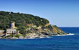 The Genoese tower in Meria | |
show Location of Meria | |
 Meria | |
| Coordinates: 42°55′40″N 9°27′12″E / 42.9278°N 9.4533°ECoordinates: 42°55′40″N 9°27′12″E / 42.9278°N 9.4533°E | |
| Country | France |
| Region | Corsica |
| Department | Haute-Corse |
| Arrondissement | Bastia |
| Canton | Cap Corse |
| Intercommunality | Cap Corse |
| Government | |
| • Mayor (2020–2026) | Laurence Piazza[1] |
| Area 1 | 20.43 km2 (7.89 sq mi) |
| Population (Jan. 2018)[2] | 90 |
| • Density | 4.4/km2 (11/sq mi) |
| Time zone | UTC+01:00 (CET) |
| • Summer (DST) | UTC+02:00 (CEST) |
| INSEE/Postal code | 2B159 /20287 |
| Elevation | 0–604 m (0–1,982 ft) (avg. 200 m or 660 ft) |
| 1 French Land Register data, which excludes lakes, ponds, glaciers > 1 km2 (0.386 sq mi or 247 acres) and river estuaries. | |


Meria is a commune in the Haute-Corse department of France on the island of Corsica.
Population[]
| Year | Pop. | ±% |
|---|---|---|
| 1962 | 107 | — |
| 1968 | 108 | +0.9% |
| 1975 | 111 | +2.8% |
| 1982 | 79 | −28.8% |
| 1990 | 76 | −3.8% |
| 1999 | 85 | +11.8% |
| 2008 | 97 | +14.1% |
See also[]
- Communes of the Haute-Corse department
- Torra di Meria
References[]
- ^ "Répertoire national des élus: les maires". data.gouv.fr, Plateforme ouverte des données publiques françaises (in French). 2 December 2020.
- ^ "Populations légales 2018". INSEE. 28 December 2020.
| Wikimedia Commons has media related to Meria. |
| show Communes of the Haute-Corse department |
|---|
This Haute-Corse geographical article is a stub. You can help Wikipedia by . |
Categories:
- Communes of Haute-Corse
- Haute-Corse geography stubs