Eudunda
| Eudunda South Australia | |||||||||||||||
|---|---|---|---|---|---|---|---|---|---|---|---|---|---|---|---|
 Eudunda seen from the town lookout | |||||||||||||||
 Eudunda | |||||||||||||||
| Coordinates | 34°10′0″S 139°05′0″E / 34.16667°S 139.08333°ECoordinates: 34°10′0″S 139°05′0″E / 34.16667°S 139.08333°E | ||||||||||||||
| Population | 570 (2016 census)[1] | ||||||||||||||
| Postcode(s) | 5374 | ||||||||||||||
| Location |
| ||||||||||||||
| LGA(s) | Regional Council of Goyder | ||||||||||||||
| County | Eyre Light | ||||||||||||||
| State electorate(s) | Stuart | ||||||||||||||
| Federal division(s) | Grey | ||||||||||||||
| |||||||||||||||
| |||||||||||||||

Eudunda is a rural town in South Australia, roughly 103 kilometres northeast of Adelaide, established in 1870 after settlers began moving into the area in the 1860s. As of the 2006 census, Eudunda had a population of 640.[1]
Eudunda is in the Regional Council of Goyder local government area, the South Australian House of Assembly electoral district of Stuart and the Australian House of Representatives Division of Grey.
Etymology and Nomenclature[]
The town name of Eudunda originates from the name of the spring to the west of the town, which local Aboriginals called judandakawi.[3] According to Dr. Phillip Clarke of the South Australian Museum, judandakawi means 'sheltered water.'[4] Alternative translations appear as Eudundacowi, Eudandakawi, or Eudundacowie. The spring still flows to this day.
Some local theories suggest that German pronunciation of the letter j led to the current pronunciation.
The earliest-known written mention of the name 'Eudunda' comes from the Adelaide newspaper, The Express and Telegraph, from 8 March 1872, where a small notice appears regarding the conveyance of mail.[5]
Weigall Street in Eudunda is named after Sir Archibald Weigall, Governor of South Australia, who visited Eudunda in December 1920 to lay the foundation stone of the hospital.[6] Hannan Street is named in honour of John Hannan, who owned the land on which the town is now situated.
History[]
The earliest European activity in the district was overlanding, centred on Narcoota and the Narcoota Track in the late 1830s. Pastoralism soon followed, with expansive 'runs' being taken up for sheep grazing by men such as Lachlan McBean, Frederick Hansborough Dutton, and William Russell. Several decades then passed before closer settlement began. In the late 1860s, Henry Watson, a Quaker, established a wine store and bar on the site of the Eudunda Hotel Motel, serving passing stockmen. The founder of Eudunda was John Henry Hannan, who owned the land that was surveyed and divided for sale.
In 1874, Friedrich Gotthilf Ernst Appelt opened Appelt's General Store on South Terrace, Eudunda. It was the first trading general store in the town. The building is listed on the South Australian Heritage Register.[7]
Railway services were first introduced to Eudunda in 1878, with the opening of the North-West Bend Railway to Morgan. The line was opened by the Governor of South Australia, Sir William Francis Drummond Jervois, on the 18th of October, 1878.[8]
In 1878 the District Council of Neales was formed, with the town becoming the centre of the local government area. The District Council lasted until 1932 when it merged with the District Council of Julia to form the District Council of Eudunda. This lasted until 1997 when the Regional Council of Goyder was formed.
In 1895, a meeting of farmers and other interested parties was held at Mann's Hotel (The Eudunda Hotel) to discuss the sale of firewood, predominantly from the Murray Flats around Sutherlands, Bower and Mount Mary, to Adelaide. This was the foundation of the state-wide store franchise, Eudunda Farmer's Co-Operative Society, which later formed Eudunda Farmers.
Eudunda's strong German culture led to a series of events during the First World War that were stoked by anti-German sentiments. A local Lutheran pastor was arrested in early 1915 for having communicated with the then Attorney-General of South Australia, Hermann Homburg, regarding matters of naturalization. Although released shortly thereafter, a further incident oc
curred on February 12, 1915. Citizen's Forces raided homes and businesses of German-born and Australian-born residents. Sentries were posted outside the town stopping travellers in and out. Although the raiders discovered nothing, the raid was also served to demonstrate that authorities were determined to suppress any disloyal feelings.[9]
On the 16th of November, 1920, world-renowned author, Colin Thiele, was born at Mutter Knabe's Nursing Home in Eudunda. His upbringing in nearby Julia, and his two-year education in Eudunda, served as great inspiration for many of his writings.

In 1950, Laucke Flour Mills acquired the prominent grain-mill building on Gunn Street, which had previously been owned by Edwin Davey.
Media[]
The Eudunda Courier and Murray Flats Advertiser was first printed in Eudunda on the 9 February 1922, by Mr. H. J. Weckert. Ownership changed in 1928 when F. T. Marsden bought the newspaper, and again in 1948 when N. W. and V. H. Baehnisch acquired it. In 1978, due to the death of V. H. Baehnisch, the newspaper closed, but after negotiation, the newspaper was taken over by the Reese and Smedley family. In 1981, the partnership changed hands, with taking ownership. The Eudunda Courier then became a supplement to the Barossa Herald. Since then, the title has been dropped, with Eudunda news items now being covered by The Leader.
The town today[]
The town landscape has changed a little from the Edwardian era – with the "Gunn Street Extension" pushing the main road from the Top Pub on Gunn Street straight through what used to be railway land toward Bruce Street and the centre of the town. The new road has further enhanced the town gardens, seen on the drive into the main centre.

Eudunda was the birthplace of world-renowned author Colin Thiele, whose bronzed sculpture (by Chris Radford) is in the Centenary Gardens. The gardens also contain stone walls and tiled art featuring a Century of Transport.
The town's distinctive German-Lutheran heritage continues with St. John's Lutheran Church and St. John's Lutheran Primary School. Many residents have German ancestry and carry Germanic surnames.
Transport[]

Eudunda was once a station on the Morgan railway line from 1878 until it closed. From 1914, it was the junction station for a branch running north past Point Pass to Robertstown.[10] It is on the Thiele Highway, and is the junction to the Worlds End Highway leading north through Robertstown towards Burra and state route B84 (Curio Road) leading west through Auburn and Balaklava to Port Wakefield.
Narcoota[]
Narcoota and associated Narcoota Springs, lie in a valleyin the south of the Eudunda locality near Neales Flat. The area featured prominently in the pioneering history of South Australia.
Located at Section 350, Hundred of Dutton, South Australia, 34°15′43″S 139°07′58″E / 34.26194°S 139.13278°E, Narcoota Springs are at the eastern escarpment of the Mount Lofty Ranges, 12 kilometers south of Eudunda, in a valley on Narcoota Creek, adjacent to the later named Smith Road.[11]
Narcoota, an indigenous name for the area, is of obscure meaning. It may be a corruption of ‘Narcoona’ – seeing – in reference to being a lookout over the Murray Plains.[12] European settlers adopted it from the outset, although it was variously spelt at first (examples are Nancoota, Tharcoota, and Nicota).
Narcoota Springs was a bustling stopover and watering place for the earliest explorers and pioneering overlanders, being a rare source of permanent water at the brink of the waterless Murray Plains. It was at the western end of the Narcoota Track, which from 1838 to 1842 was part of the main (and first) road between the Murray River and Adelaide. At the eastern end was The Pound, 9 km north of Blanchetown, which years later became named McBean Pound at Roonka Station. The overland road diverged at the Pound – one track went south toward Mount Barker and the other west to Narcoota, then on to Gawler Town and Adelaide.
Apart from overlanding parties droving large mobs of livestock from New South Wales, Narcoota Springs had some distinguished visitors in its heyday. They included Governor George Gawler and explorer Charles Sturt, as well as Henry Inman, Commander of Police, who passed through there at least five times.[13]

The first was in 1839 when Inman led a police party to the Weston Flat district to investigate conflict resulting in the death of one over-lander and an unknown number of Aboriginals. Months later he was back again when he took part in the exploration expedition of Governor Gawler from North West Bend to Mount Bryan.
In 1841 Inman was there again after his own over-landing party was attacked near Chowilla, losing 5,000 sheep. He again camped there as part of the 68-man police party led by Commissioner of Police Thomas Shuldham O'Halloran, sent by Governor George Grey to protect other over-landers at the Rufus River.
After a settlement was established in late 1841 by Edward John Eyre at Moorundie (8 km below Blanchetown, South Australia), the overland route then shifted further south, roughly following the present Sturt Highway between Blanchetown and Truro. The Narcoota Track became disused thereafter.[14]
Later in the 1840s a pastoral property named Narcoota Station was established. Nearby is Mount Rufus, where gold was discovered in 1868, but without much result. With closer settlement in the latter part of the 1800s, many grain farmers moved into the district, such that by 1900 there were busy schools and churches. Over a century later many stone ruins attest to the failure of close settlement, but those pioneering foundations produced the farms and grazing properties which thrive there
today.
Geologically, the beds outcropping along Narcoota Creek are so typical in structure and stratigraphy of geological features occurring in several locations throughout the North Mount Lofty Ranges, that the name Narcoota Series has been adopted for the entire group.[15]
Gallery[]
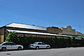
Eudunda Bakery.
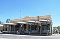
The former Appelt's General Store, now the Eudunda Roadhouse. Located on South Terrace.
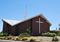
St. John's Lutheran Church, Eudunda. Dedicated in 1980.

The Eudunda office of the Regional Council of Goyder, formerly the office for the District Council of Eudunda.
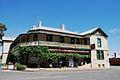
The Light Hotel, formerly the Royal Hotel.
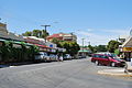
Part of Bruce Street, Eudunda, looking in a southerly direction.


References[]
- ^ a b https://quickstats.censusdata.abs.gov.au/census_services/getproduct/census/2016/quickstat/UCL421011?opendocument
- ^ a b c "Monthly climate statistics: Summary statistics Summary statistics EUDUNDA (nearest weather station)". Commonwealth of Australia , Bureau of Meteorology. Retrieved 2 April 2018.
- ^ "Ernaballa - Eurelia". manning.collections.slsa.sa.gov.au. Retrieved 11 January 2020.
- ^ Dreckow, B (1986). Hills, Valley and Plains: History of the Eudunda District. p. 7.
- ^ "POST OFFICE DEPARTMENT". 8 March 1872.
- ^ "VICEREGAL VISIT TO EUDUNDA". 3 December 1920.
- ^ "Former Appelts Store, Eudunda Roadhouse". South Australian Heritage Register. Department of Environment, Water and Natural Resources. Retrieved 8 April 2016.
- ^ "OPENING OF THE NORTH-WEST BEND RAILWAY".
- ^ "Kapunda Herald, 12th of February 1915. COUNTRY NEWS - EUDUNDA".
- ^ "ROBERTSTOWN RAILWAY". The Advertiser. Adelaide. 10 December 1914. p. 9. Retrieved 23 September 2015 – via National Library of Australia.
- ^ Geographical Names in Australia, Gazetteer of Australia 2008, Geoscience Australia
- ^ Australian Aboriginal Words, H.M. Cooper, SA Museum 1948 (1st ed.)
- ^ Inman: first commander of the SA Police / Max Slee (Seaview Press, 2010)
- ^ Hills, valley and plains: history of the Eudunda District / compiled by Betty Dreckow (Eudunda, 1986).
- ^ The geology of part of the North Mount Lofty Ranges, by Paul S. Hossfeld, M.Sc., FGS, GRGS. (SA Museum 1928)
External links[]
| Wikimedia Commons has media related to Eudunda, South Australia. |
- Towns in South Australia
- Geology of South Australia