European route E80
 | |
|---|---|
 | |
| Route information | |
| Length | 6,102 km (3,792 mi) |
| Major junctions | |
| West end | |
| East end | |
| Location | |
| Countries | |
| Highway system | |
| |
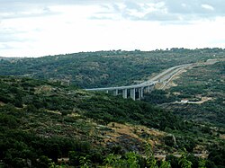
European route 80 in the section Guarda - Vilar Formoso, Portugal.
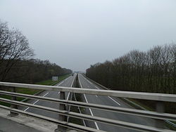

European route 80 near Sarzana, Italy.

European route 80 near Dragoman, Bulgaria (border to Serbia).

Bilingual sign to E 80 in Sofia.
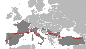
European route E 80, also known as Trans-European Motorway or TEM, is an A-Class West-East European route, extending from Lisbon, Portugal to Gürbulak, Turkey, on the border with Iran. The road connects 10 countries and has a length of approximately 6,102 kilometres (3,792 mi). At its eastern end it joins end-on with Asian Highway AH1 which continues all the way to Japan.
Route[]
![]() Portugal
Portugal

 A1 / : Lisbon (
 E90, start of concurrency with
  E01) - Torres Novas (
 E806) - Coimbra (
 E801) - Aveiro (end of concurrency with E01)
 A25: Aveiro ( E01) - Viseu ( E801) - Guarda (
 E802 E806) - Vilar Formoso
![]() Spain
Spain
 A-62: Fuentes de Oñoro - Salamanca (
 E803) - Tordesillas (
 E82) - Burgos
 : Burgos (
 E5)
E5) A-1: Burgos (start of concurrency with E5)
 AP-1: Burgos - Miranda de Ebro (
 E804) - Vitoria-Gasteiz
 : Vitoria-Gasteiz
- AP-1: Vitoria-Gasteiz - Eibar (
 E70)
E70)  AP-1 / AP-8: Eibar (start of concurrency with E70) - Donostia/S. Sebastian - Irún
![]() France
France
 A63: Hendaye - Bayonne (end of concurrency with
  E5
E5  E70)
E70) A64: Bayonne ( E5 E70) - Pau (
 E7) - Toulouse (
 E9)
E9) : Toulouse ( E9
  E72)
E72) A61: Toulouse ( E72) - Villefranche-de-Lauragais ( E72) - Carcassonne - Narbonne (
 E15)
E15) A9: Narbonne (start of concurrency with E15) - Béziers (
 E11) - Montpellier - Nîmes (end of concurrency with E15)
 A54: Nîmes ( E15) - Salon-de-Provence (
 E714)
E714) A7: Salon-de-Provence ( E714) - Aix-en-Provence ( E714)
 A8: Aix-en-Provence (
 E712 E714) - Nice
![]() Italy
Italy
 A10: Ventimiglia (
 E74) - Savona (
 E717) - Genoa (
 E25)
E25) A12: Genoa ( E25
 E62) - La Spezia (
 E33) - Lucca (
 E76) - Rosignano Solvay
 SS 1: Rosignano Solvay - Grosseto (
 E78) - Tarquinia (
 E840)
E840)- A12: Tarquinia ( E840) - Civitavecchia
 A91: Civitavecchia - Rome
 A90: Rome (
 E35
E35  E821)
E821) A24: Rome - Tivoli (
 E45) - Borgorose
 A25: Borgorose - Pescara
 : Pescara (
 E55)
E55) SS 16dir-C: Pescara ( E55) - Porto di Pescara
Gap - Adriatic Sea
 :
:  Porto di Pescara -
  Dubrovnik
![]() Croatia
Croatia
 D8: Dubrovnik (start of concurrency with
  E65) - Karasovići
![]() Montenegro
Montenegro
 M-1: Debeli Brijeg - Petrovac na Moru (start of concurrency with
  E-851) - Sutomore (end of concurrency with E-851)
 M-1.1: Sutomore ( E-851) - Virpazar
 M-2: Virpazar - Podgorica (
 E-762) - Ribarevina (
 E-763)
 M-5: Ribarevina ( E-763) - Berane[b] -
![]() Serbia
Serbia
![]() Kosovo[a]
Kosovo[a]
 M-2: Mitrovica - Pristina (end of concurrency with
  E65)
E65) R7: Prishtina -
  M-25: -
![]() Serbia
Serbia
 35: Merdare - Prokuplje - Merošina (start of concurrency with
  E75)
E75) A1: Merošina - Trupale (end of concurrency with E75)
 A4: Niš - Pirot - Gradinje (
 E771)
E771)
![]() Bulgaria
Bulgaria
 I-8: Kalotina - Dragoman
 A6: Dragoman - Sofia (
 E79)
E79) I-18: Sofia ( E79
  E871)
E871) A1: Sofia - Plovdiv - Chirpan (
 E773)
E773) A4: Chirpan ( E773) - Dimitrovgrad (
 E85) - Svilengrad ( E85) - Kapitan Andreevo
![]() Turkey
Turkey
 D.100: Kapıkule - Edirne
 O-3: Edirne - Babaeski (
 E87) - Silivri (
 E84) - Istanbul
 O-7: Istanbul[c]
 O-4: Istanbul - Gebze - Izmit (
 E881) - Düzce - Bolu - Gerede (
 E89)
E89)- D.100: Gerede ( E89) - Ilgaz - Merzifon (
 E95) - Refahiye (
 E88) - Erzincan - Aşkale (
 E97) - Erzurum - Horasan (
 E691) - Ağrı - Doğubeyazıt (
 E99) - Gürbulak
![]() Iran
Iran

 Road 32: Bazargan
Coordinates[]
- Western Terminus - Lisbon 38°47′24.2″N 9°6′49.6″W / 38.790056°N 9.113778°W
- Eastern Terminus - Gürbulak 39°24′37″N 44°22′41.6″E / 39.41028°N 44.378222°E

Notes[]
- ^ a b Kosovo is the subject of a territorial dispute between the Republic of Kosovo and the Republic of Serbia. The Republic of Kosovo unilaterally declared independence on 17 February 2008. Serbia continues to claim it as a part of its own sovereign territory. The two governments began to normalise relations in 2013, as part of the 2013 Brussels Agreement. Kosovo is currently recognised as an independent state by 97 out of the 193 United Nations member states. In total, 112 UN member states have recognised Kosovo at some point, of which 15 states later withdrew their recognition.
- ^ The route between Montenegro and Kosovo is unclear, a problem currently shared with E65 which is concurrent with E80 on this section. The existing M-2 road that goes through Bijelo Polje continues northwards through western Serbia as E763, away from the direction of Pristina. Instead the route needs to turn to the east some 4 km (2.5 mi) before Bijelo Polje, at Ribarevina junction, and towards Priština. After that, the route goes southeast, throrugh Berane and Rožaje, where the route winds slightly northwards again, goes through western Serbia near Tutin, and then enters Kosovo near Zubin Potok.
- ^ Previously
 O-2 was used, it has been banned to use by transit trucks and busses since opening of Yavuz Sultan Selim Bridge.
External links[]
| Wikimedia Commons has media related to E80. |

Categories:
- International E-road network
- Roads in Portugal
- Roads in Spain
- Roads in France
- Roads in Italy
- Roads in Croatia
- Roads in Montenegro
- European routes in Kosovo
- Roads in Serbia
- Roads in Bulgaria
- Roads in Turkey