Fuentes de Oñoro
Fuentes de Oñoro | |
|---|---|
 Flag  Seal | |
 Location in Salamanca | |
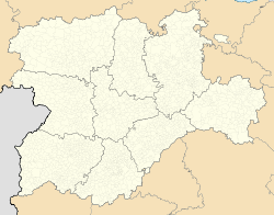 Fuentes de Oñoro Location of Fuentes de Oñoro | |
| Coordinates: 40°35′18″N 6°48′47″W / 40.58833°N 6.81306°WCoordinates: 40°35′18″N 6°48′47″W / 40.58833°N 6.81306°W | |
| Country | |
| Autonomous community | |
| Province | Salamanca |
| Comarca | Comarca de Ciudad Rodrigo |
| Subcomarca | Campo de Argañán |
| Government | |
| • Mayor | Isidoro José Alanís Marcos (PP) |
| Area | |
| • Total | 57 km2 (22 sq mi) |
| Elevation | 734 m (2,408 ft) |
| Population (2018)[2] | |
| • Total | 1,188 |
| • Density | 21/km2 (54/sq mi) |
| Time zone | UTC+1 (CET) |
| • Summer (DST) | UTC+2 (CEST) |
| Postal code | 37480 |


Fuentes de Oñoro is a village and municipality in the province of Salamanca, western Spain, part of the autonomous community of Castile-Leon. It is located 124 kilometres (77 mi) from the provincial capital city of Salamanca, and has a population of 1058 people. It was the site of a significant battle in 1811, during the Peninsular War.
It is a border town, and is directly connected to the most important Portuguese terrestrial border of Vilar Formoso.
Geography[]
The municipality covers an area of 57 km2 (22 sq mi). It lies 725 metres (2,379 ft) above sea level and the postal code is 37480.
See also[]
- Battle of Fuentes de Oñoro
- List of municipalities in Salamanca
References[]
- ^ Jump up to: a b "Municipio:Fuentes de Oñoro". www.lasalina.es. Retrieved 2017-11-02.
- ^ Municipal Register of Spain 2018. National Statistics Institute.
| show Municipalities in the province of Salamanca |
|---|
| Authority control |
|---|
This article about a location in the province of Salamanca, Spain, is a stub. You can help Wikipedia by . |
Categories:
- Municipalities in the Province of Salamanca
- Portugal–Spain border crossings
- Province of Salamanca geography stubs