La Peña, Salamanca
La Peña | |
|---|---|
 Flag  Seal | |
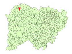 Location in Salamanca | |
 La Peña Location in Spain | |
| Coordinates: 41°10′30″N 06°31′10″W / 41.17500°N 6.51944°WCoordinates: 41°10′30″N 06°31′10″W / 41.17500°N 6.51944°W | |
| Country | Spain |
| Autonomous community | Castile and León |
| Province | Salamanca |
| Comarca | Vitigudino |
| Subcomarca | La Ramajería |
| Government | |
| • Mayor | José Tomás Hernández Rebollo (People's Party) |
| Area | |
| • Total | 25 km2 (10 sq mi) |
| Elevation | 696 m (2,283 ft) |
| Population (2018)[2] | |
| • Total | 100 |
| • Density | 4.0/km2 (10/sq mi) |
| Time zone | UTC+1 (CET) |
| • Summer (DST) | UTC+2 (CEST) |
| Postal code | 37214 |

La Peña is a municipality located in the province of Salamanca, Castile and León, Spain.
References[]
- ^ Jump up to: a b "Municipio:Peña (La)". www.lasalina.es. Retrieved 2017-10-28.
- ^ Municipal Register of Spain 2018. National Statistics Institute.
| show Municipalities in the province of Salamanca |
|---|
This article about a location in the province of Salamanca, Spain, is a stub. You can help Wikipedia by . |
Categories:
- Municipalities in the Province of Salamanca
- Province of Salamanca geography stubs