Eynhallow
| Scots name | Eynhallow[1] |
|---|---|
| Old Norse name | Eyinhelga[2] |
| Meaning of name | "Holy Island" |
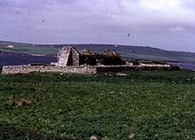
 Eynhallow viewed from Rousay, from the north-east, with the Orkney Mainland beyond | |
| Location | |
 Eynhallow Eynhallow shown within Orkney | |
| OS grid reference | HY359291 |
| Coordinates | 59°08′N 3°07′W / 59.14°N 3.11°W |
| Physical geography | |
| Island group | Orkney |
| Area | 75 hectares (0.29 sq mi) |
| Area rank | 168 [3] |
| Highest elevation | 30 metres (98 ft) |
| Administration | |
| Sovereign state | United Kingdom |
| Country | Scotland |
| Council area | Orkney Islands |
| Demographics | |
| Population | 0[4] |
| References | [5][6][7][8] |

Eynhallow (Scots: Eynhallow; Old Norse: Eyinhelga; Norn: Øjinhellig) is a small, presently uninhabited island, part of Orkney, off the north coast of mainland Scotland.
Geography[]

Eynhallow lies in Eynhallow Sound between Mainland, Orkney and Rousay. It is 75 hectares (0.29 square miles) in area. An unnamed skerry is situated approximately 100 metres (330 feet) to the north-east of the island, separated by Fint Sound. Sheep Skerry adjoins the southern end of the island.
There is no ferry to the island, although Orkney Heritage Society organises a trip each July.[9] Otherwise, visitors have to arrange their own transport to the island by private local boat hire. Access can be problematic, as there are strong tidal surges in the surrounding strait, squeezed between Mainland of Orkney and Rousay.[10]
History[]
The island's main attraction is Eynhallow Church dating from the twelfth century or earlier, and perhaps originally part of a monastery.[11] The site is maintained by Historic Scotland.
In 1841 the island had a population of 26.[11] It has been uninhabited since the landowner cleared crofters away in 1851. The clearing led to the discovery of the church ruins, forgotten until then.[12] It is now a bird sanctuary.
It has its own folklore, concerning the initial finding of the island. Eynhallow was believed to be the summer residence of the shape-shifting mer-people the Finfolk, who were driven away by the farmer, Guidman o' Thorodale from Evie.[13][14]
See also[]
- Gurness
Notes[]
- ^ "Map of Scotland in Scots - Guide and gazetteer" (PDF).
- ^ Anderson (1873) p. 176
- ^ Area and population ranks: there are c. 300 islands over 20 ha in extent and 93 permanently inhabited islands were listed in the 2011 census.
- ^ National Records of Scotland (15 August 2013). "Appendix 2: Population and households on Scotland's Inhabited Islands" (PDF). Statistical Bulletin: 2011 Census: First Results on Population and Household Estimates for Scotland Release 1C (Part Two) (PDF) (Report). SG/2013/126. Retrieved 14 August 2020.
- ^ Haswell-Smith (2004) pp. 381-83
- ^ Ordnance Survey: Landranger map sheet 6 Orkney (Mainland) (Map). Ordnance Survey. 2014. ISBN 9780319228128.
- ^ Orkney Placenames
- ^ Pedersen, Roy (January 1992) Orkneyjar ok Katanes (map, Inverness, Nevis Print)
- ^ Orkney Heritage Society website
- ^ "Eynhallow". Around Rousay. Retrieved 8 January 2008.
- ^ a b "Overview of Eynhallow". Gazetteer for Scotland. Retrieved 5 January 2008.
- ^ "Eynhallow Church". Historic Environment Scotland. Retrieved 16 January 2022.
- ^ "Folklore". orkneyjar.com. Retrieved 8 January 2008.
- ^ Turnbull, Catherine (29 July 2010) "Exploring the Mysteries of Eynhallow". Kirkwall: Orkney News.
References[]
- Haswell-Smith, Hamish (2004). The Scottish Islands. Edinburgh: Canongate. ISBN 978-1-84195-454-7.
- Anderson, Joseph (ed.) (1873) The Orkneyinga Saga. Translated by Jón A. Hjaltalin & Gilbert Goudie. Edinburgh. Edmonston and Douglas. The Internet Archive. Retrieved 26 August 2013.
External links[]
| Wikimedia Commons has media related to Eynhallow. |
Coordinates: 59°8′41″N 3°7′11″W / 59.14472°N 3.11972°W
This Orkney location article is a stub. You can help Wikipedia by . |
- Sites of Special Scientific Interest in Orkney
- Uninhabited islands of Orkney
- Former populated places in Scotland
- Bird sanctuaries
- Orkney geography stubs