Helliar Holm
 The West Coast of Helliar Holm low tide on a rainy day and the wave-cut platform is exposed. | |
| Location | |
|---|---|
 Helliar Holm Helliar Holm shown within Orkney | |
| OS grid reference | HY484153 |
| Coordinates | 59°01′23″N 2°54′04″W / 59.023°N 2.901°W |
| Physical geography | |
| Island group | Orkney |
| Administration | |
| Sovereign state | United Kingdom |
| Country | Scotland |
| Council area | Orkney Islands |
| Demographics | |
| Population | 0 |
| Helliar Holm Lighthouse | |
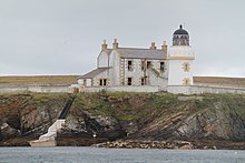 Saeva Ness lighthouse at the southern end of Helliar Holm | |
| Constructed | 1893 |
| Construction | stone tower |
| Height | 42 ft (13 m) |
| Shape | cylindrical tower with balcony and lantern |
| Markings | white tower, black lantern, ochre trim |
| Power source | solar power |
| Operator | Northern Lighthouse Board[2] |
| Heritage | category B listed building |
| Automated | 1967 |
| Focal height | 18 m (59 ft) |
| Range | white: 14 nautical miles (26 km; 16 mi) red: 10 nautical miles (19 km; 12 mi) [1] |
| Characteristic | Fl WRG 10s |

Helliar Holm is an uninhabited island off the coast of Shapinsay in the Orkney Islands, Scotland. It is home to a 42-foot-tall (13 m) lighthouse, which was built in 1893 and automated in 1967.[3] It is a tidal island that used to be connected to Shapinsay. It is still possible to walk across from the mainland during very low tides.
The island also has the ruins of a broch, cairn and chapel.[4]
In the Orkneyinga Saga it is referred to as both "Hellisey" and "Eller Holm" [5] and John of Fordun refers to it as "Helene-holm"
Gallery[]
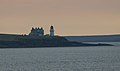
Saeva Ness lighthouse on the tip of Helliar Holm
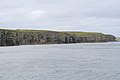
Cliffs and chambered cairn on Helliar Holm.


See also[]
References[]
- ^ Helliar Holm Light Lighthouses Explorer. Retrieved 27 May 2016
- ^ Rowlett, Russ. "Lighthouses of Scotland: Orkney". The Lighthouse Directory. University of North Carolina at Chapel Hill. Retrieved 2016-05-27.
- ^ Lighthouse Explorer database
- ^ Haswell-Smith, Hamish. (2004) The Scottish Islands. Edinburgh. Canongate.
- ^ Anderson, Joseph (Ed.) (1893) Orkneyinga Saga. Translated by Jón A. Hjaltalin & Gilbert Goudie. Edinburgh. James Thin and Mercat Press (1990 reprint). ISBN 0-901824-25-9
External links[]
| Wikimedia Commons has media related to Helliar Holm. |
Coordinates: 59°01′23″N 02°54′05″W / 59.02306°N 2.90139°W
This Orkney location article is a stub. You can help Wikipedia by . |
This British lighthouse-related article is a stub. You can help Wikipedia by . |
- Pages using infobox lighthouse with custom Wikidata item
- Tidal islands of Scotland
- Shapinsay
- Uninhabited islands of Orkney
- Orkney geography stubs
- European lighthouse stubs
- United Kingdom building and structure stubs