Graemsay
| Old Norse name | Grímsey[1] |
|---|---|
| Meaning of name | Grímr's Island |
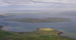 An aerial view of Graemsay, from above Hoy | |
| Location | |
 Graemsay Graemsay shown within Orkney | |
| OS grid reference | HY255055 |
| Coordinates | 58°55′59″N 3°17′00″W / 58.933°N 3.2833°W |
| Physical geography | |
| Island group | Orkney Islands |
| Area | 409 ha (1.58 sq mi) |
| Area rank | 76 [2] |
| Highest elevation | West Hill 62 m (203 ft) |
| Administration | |
| Sovereign state | United Kingdom |
| Country | Scotland |
| Council area | Orkney |
| Demographics | |
| Population | 28[3] |
| Population rank | 60 [2] |
| Population density | 6.8 people/km2[3][4] |
| Largest settlement | Breckan |
| References | [4][5][6] |

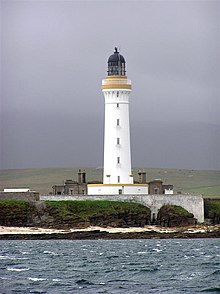 Hoy High Lighthouse in 2003 | |
 | |
| Location | Graemsay Island Orkney Scotland United Kingdom |
|---|---|
| OS grid | HY2680906078 |
| Coordinates | 58°56′08″N 3°16′24″W / 58.935665°N 3.273202°W |
| Constructed | 1851 |
| Designed by | Alan Stevenson |
| Construction | stone tower |
| Tower height | 33 metres (108 ft) |
| Tower shape | cylindrical tower with balcony and lantern |
| Markings | white tower, black lantern, ochre trim |
| Operator | Northern Lighthouse Board[7] |
| Heritage | category A listed building |
| Automated | 1978 |
| Focal height | 35 metres (115 ft) |
| Range | white: 20 nautical miles (37 km; 23 mi) red: 16 nautical miles (30 km; 18 mi) [8] |
| Characteristic | Oc WR 8s. |
| Admiralty no. | A3644 |
| NGA no. | 3200 |
| ARLHS no. | SCO-104 |
Graemsay is an island in the western approaches to Scapa Flow, in the Orkney Islands of Scotland. The island has two lighthouses. Graemsay lies within the parish of Stromness.
Geography and geology[]
Graemsay lies between Hoy and Stromness on Mainland Orkney, separated from the Mainland by Clestrain Sound. The island is 409 ha (1.58 sq mi) in area and is mainly crofted.
The island's geology is Old Red Sandstone of the Devonian period, with two volcanic faults. On the north coast there is granite-schist, a great rarity in Orkney.
Graemsay is surrounded by strong tidal races, known locally as roosts. An Orkney Ferries service, usually operated by MV Graemsay, links the island with Stromness and on Hoy.
Graemsay is sometimes referred to locally, as 'Orkney's green isle' due to its lush green vegetation cover.
Wildlife[]
Birds include oystercatchers, ringed plovers, redshank and curlew. Parts of the island are largely undeveloped and are a haven for wild plants.[citation needed]
History[]
As with many other Orkney Islands, there is a connection to the Celtic Church, possibly a pre-Norse one. There are the remains of two early churches, dedicated to St Bride and to St Columba.,[4] who are both saints of Irish origin.
The island has two lighthouses, Hoy High (NE) and Hoy Low (NW), both built in 1851 by Alan Stevenson[9] for the 19th-century herring industry.
At the Point of Oxan in the far north west, in Burra Sound, are block ships, which were scuttled deliberately during World War II. This is a common feature of the straits and former straits around Scapa Flow. A Coastal Defence Battery also sits at the point of Oxan, built in 1944, and guarding the western entrance to Scapa Flow, until the end of WW2.
Graemsay primary school was built in 1876 and once had a peak enrollment of 60 pupils. In the late 1990s the school had four staff to just one pupil, making it the most expensive state school in the United Kingdom.[10] The school closed in 1996. Today, the island's children travel daily by boat to school in Stromness on the ferry MV Graemsay.[4]
Lighthouses[]
Two lighthouses are present on Graemsay: Hoy Sound Low and Hoy Sound High located at the extremities of the northern side of the island. The lights were built in 1851 on project by Alan Stevenson; both are cylindrical tower with balcony and lantern, even if of different heights, white painted with black lantern and the typical ochre trims.
The Hoy High Light, known as Graemsay Island Range Rear, is 33 metres (108 ft) high and has a white and red occulting light every 8 seconds depending on the directions.
The Hoy Low Light (Graemsay Island Range Front) is 12 metres (39 ft) high and is distinguished by a white isophase light every 3 seconds. The two Range lighthouses direct the ships towards the Hoy Sound from the Atlantic.
See also[]
- List of islands in Scotland
- List of lighthouses in Scotland
- List of Northern Lighthouse Board lighthouses
References[]
- ^ Anderson, Joseph (ed.) (1873) The Orkneyinga Saga. Translated by Jón A. Hjaltalin & Gilbert Goudie. Edinburgh. Edmonston and Douglas. The Internet Archive. Retrieved 26 August 2013.
- ^ Jump up to: a b Area and population ranks: there are c. 300 islands over 20 ha in extent and 93 permanently inhabited islands were listed in the 2011 census.
- ^ Jump up to: a b National Records of Scotland (15 August 2013). "Appendix 2: Population and households on Scotland's Inhabited Islands" (PDF). Statistical Bulletin: 2011 Census: First Results on Population and Household Estimates for Scotland Release 1C (Part Two) (PDF) (Report). SG/2013/126. Retrieved 14 August 2020.
- ^ Jump up to: a b c d Haswell-Smith, Hamish (2004). The Scottish Islands. Edinburgh: Canongate. ISBN 978-1-84195-454-7.
- ^ Ordnance Survey. OS Maps Online (Map). 1:25,000. Leisure.
- ^ Mac an Tàilleir, Iain (2003) Ainmean-àite/Placenames. (pdf) Pàrlamaid na h-Alba. Retrieved 26 August 2012.
- ^ Rowlett, Russ. "Lighthouses of Scotland: Orkney". The Lighthouse Directory. University of North Carolina at Chapel Hill. Retrieved 2016-05-25.
- ^ Hoy Sound High Lighthouses Explorer. Retrieved 25 May 2016
- ^ "Graemsay website". Retrieved 2007-07-22.
- ^ "News:Independent - The boy with four teachers and a school to himself".
Book about the History of Graemsay[]
External links[]
- Run by the current residents of Hoy High Lighthouse, and attempts to give a flavour of life today on Graemsay
- The largest building, Sandside House, has been renovated and this web site describes the property and the island.
- Contains information about all Graemsay families
- Northern Lighthouse Board
| Wikimedia Commons has media related to Graemsay. |
Coordinates: 58°56′N 3°17′W / 58.933°N 3.283°W

| Authority control |
|
|---|
- Islands of the Orkney Islands