Fang County
Fang County
房县 | |
|---|---|
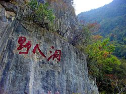 Inscription in cliff face next to the entrance of the "Yeren Cave". The inscription reads "Ye Ren Dong" ("Wild Man Cave"). | |
 Fangxian Location in Hubei | |
| Coordinates: 32°06′N 110°36′E / 32.100°N 110.600°ECoordinates: 32°06′N 110°36′E / 32.100°N 110.600°E | |
| Country | People's Republic of China |
| Province | Hubei |
| Prefecture-level city | Shiyan |
| Area | |
| • Total | 5,110 km2 (1,970 sq mi) |
| Population (2010)[1] | |
| • Total | 390,991 |
| • Density | 77/km2 (200/sq mi) |
| Time zone | UTC+8 (China Standard) |

Fang County or Fangxian (simplified Chinese: 房县; traditional Chinese: 房縣; pinyin: Fáng Xiàn) is a county of northwestern Hubei province, People's Republic of China. It is under the administration of Shiyan City.
The county spans an area of 5,110 square kilometres (1,970 sq mi),[2] and has a population of 390,991 as of 2010.[1]
History[]
During the Spring and Autumn period, the region was known as Fangzhu (Chinese: 防渚; pinyin: Fángzhǔ).[1]
During the Warring States period, the area belonged to the State of Chu.[1]
The area was incorporated as Fangling County (simplified Chinese: 房陵县; traditional Chinese: 房陵縣; pinyin: Fánglíng Xiàn) during the Qin dynasty, where it belonged to the .[1]
In 636 CE, the area of present-day Fang County was organized as .[1]
In 1277, Fang Prefecture was changed to Fang County, which it has remained since.[1] It was placed under the jurisdiction of .[1]
In 1476, Xiangyang Fu was changed to .[1]
Republic of China[]
Upon the establishment of the Republic of China, the area was placed under the jurisdiction of .[1]
In 1931, the area was re-organized as the 11th of Hubei Province.[1] In 1936, it was changed to be under the 8th Administrative Inspectorate of Hubei Province.[1]
People's Republic of China[]
In 1949, upon the establishment of the People's Republic of China, the area was administered under the .[1]
The area was moved to the jurisdiction of the in 1965.[1]
In 1994, the county was moved to the jurisdiction of the newly-formed prefecture-level city of Shiyan.[1]
Geography[]
The Wudang Mountains run through the northern part of Fang County, and the Daba Mountains run through its southern part.[2]
The lowest part of the county is Jiangjiapo (Chinese: 姜家坡), in , which stands 180 metres (590 ft) above sea level.[2] The highest part of the county is Guanjiaya (Chinese: 关家垭), in , which stands 2,485.6 metres (8,155 ft) above sea level.[2]
Administrative divisions[]
Fang County administers 12 towns and 8 townships.[3][4]
| Name | Hanzi | Pinyin | Division type | Population (2010)[1] |
|---|---|---|---|---|
| 城关镇 | Chéngguān Zhèn | Town | 89,898 | |
| 军店镇 | Jūndiàn Zhèn | Town | 32,346 | |
| 化龙堰镇 | Huàlóngyàn Zhèn | Town | 20,163 | |
| 土城镇 | Tǔchéng Zhèn | Town | 16,404 | |
| 大木厂镇 | Dàmùchǎng Zhèn | Town | 26,828 | |
| 青峰镇 | Qīngfēng Zhèn | Town | 27,231 | |
| 门古寺镇 | Méngǔsì Zhèn | Town | 26,488 | |
| 白鹤镇 (房县) | Báihè Zhèn | Town | 28,435 | |
| 野人谷镇 | Yěréngǔ Zhèn | Town | 9,638 | |
| 红塔镇 | Hóngtǎ Zhèn | Town | 31,367 | |
| 窑淮镇 | Yáohuái Zhèn | Town | 10,763 | |
| Yinjifu | 尹吉甫镇 | Yǐnjífǔ Zhèn | Town | 7,261 |
| 姚坪乡 | Yáopíng Xiāng | Township | 13,008 | |
| 沙河乡 | Shāhé Xiāng | Township | 7,197 | |
| 万峪河乡 | Wànyùhé Xiāng | Township | 6,917 | |
| 上龛乡 | Shàngkān Xiāng | Township | 8,712 | |
| 中坝乡 | Zhōngbà Xiāng | Township | 7,130 | |
| 九道乡 | Jiǔdào Xiāng | Township | 8,675 | |
| Huilong Township | 回龙乡 | Huílóng Xiāng | Township | 3,022 |
| 五台乡 | Wǔtái Xiāng | Township | 3,268 |
Former divisions[]
In March 2012, Langkou Township (Chinese: 榔口乡; pinyin: Lángkǒu Xiāng) was abolished, and merged into the town of Yinjifu.[1]
Economy[]
Mineral deposits in the county include copper, iron, lead, zinc, phosphorus, sulfur, coal, and gypsum.[2]
A number of large caves in Fang County also serve as tourist attractions.[2]
Transport[]
National Highway 209 runs through the county.[2]
References[]
- ^ Jump up to: a b c d e f g h i j k l m n o p q r 房县历史沿革 [Fang County Historical Development]. xzqh.org (in Chinese). 2014-07-22. Archived from the original on 2021-02-03. Retrieved 2021-02-03.
- ^ Jump up to: a b c d e f g 房县概况地图 [Fang County Overview]. xzqh.org (in Chinese). 2014-07-22. Archived from the original on 2020-06-03. Retrieved 2021-02-03.
- ^ Jump up to: a b 2020年统计用区划代码(房县) [2020 Statistical Division Codes (Fang County)] (in Chinese). National Bureau of Statistics of China. 2020. Archived from the original on 2021-02-03. Retrieved 2021-02-03.
- ^ 房县行政区划 [Fang County Administrative Divisions]. 房县政府网 [Fang County Government Web] (in Chinese). 29 May 2018. Retrieved 13 December 2018.
城关镇{...}军店镇{...}化龙堰镇{...}门古寺镇{...}大木厂镇{...}青峰镇{...}土城镇{...}窑淮镇{...}尹吉甫镇{...}红塔镇{...}白鹤镇{...}野人谷镇{...}沙河乡{...}万峪河乡{...}九道乡{...}上龛乡{...}中坝乡{...}姚坪乡{...}五台乡{...}黑獐沟{...}九口山{...}杨岔山{...}温泉{...}旱粮场{...}毛家山{...}潭家湾{...}西蒿{...}代东河{...}
- County-level divisions of Hubei
- Shiyan
- Fang County