Badong County
Badong County
巴东县 Patung | |
|---|---|
 | |
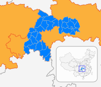
 Badong Location of the seat in Hubei | |
| Coordinates (Badong County government): 31°02′32″N 110°20′27″E / 31.0423°N 110.3408°ECoordinates: 31°02′32″N 110°20′27″E / 31.0423°N 110.3408°E | |
| Country | People's Republic of China |
| Province | Hubei |
| Autonomous prefecture | Enshi |
| Area | |
| • Total | 3,219 km2 (1,243 sq mi) |
| Population (2010)[1] | |
| • Total | 420,840 |
| • Density | 130/km2 (340/sq mi) |
| Time zone | UTC+8 (China Standard) |
| Website | www |

Badong County (simplified Chinese: 巴东县; traditional Chinese: 巴東縣; pinyin: Bādōng Xiàn; lit. 'East of (state of) Ba') is a county located in western Hubei province, People's Republic of China, bordering Chongqing municipality to the west. It is the northernmost county-level division under the administration of Enshi Prefecture. The Yangtze River flows through the county and the county seat is located just east of the Wu Gorge in the Three Gorges region.
Badong County is famous for the Shen Nong Stream (神农溪; Shénnóng Xī) gorges located near Badong town. The stream itself falls into the Yangtze opposite the Badong center city.

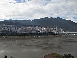
The Badong county seat, commonly referred to simply as "Badong", is in the town of Xinling (信陵镇; Xìnlíng Zhèn), located on the high southern banks of the Yangtze River channel. The Yangtze valley was flooded during the first decade of the 21st century after the construction of the Three Gorges Dam to the east, but Badong county seat was mostly above the flood line, and so more of the original town survives than is the case in many other river towns along this section of the Yangtze.
Administrative divisions[]

Badong County is divided into 10 towns and 2 townships.[1][2][3]
Ten towns:
- (信陵镇; Xìnlíng Zhèn)
- Dongrangkou (东瀼口镇; Dōngrǎngkǒu[citation needed] Zhèn)
- (沿渡河镇; Yándùhé Zhèn)
- (官渡口镇; Guāndùkǒu Zhèn)
- (茶店子镇; Chádiànzǐ Zhèn)
- (绿葱坡镇; Lǜcōngpō Zhèn)
- (大支坪镇; Dàzhīpíng Zhèn)
- (野三关镇; Yěsānguān Zhèn)
- (清太坪镇; Qīngtàipíng Zhèn)
- (水布垭镇; Shuǐbùyà Zhèn)
Two townships:
The main urban area of the county (i.e., the place typically labeled "Badong" on less-detailed maps) consists of Xinling Town - the seat of the county government - on the right (southern) bank of the Yangtze, and the smaller Dongrangkou and Guandukou towns on the opposite side of the river. They two sides of the Yangtze are connected by the Badong Bridge.
Economy[]
Coal mining in small pits is the main commercial activity in the region, along with farming. There is also a large cement factory on the river to the east of the town, which is a significant polluter.
The rural population of Badong County, as with many other parts of inland China, has seen major changes in the past two decades. The Chinese government's population control policies in the 1980s and beyond resulted in a sharp drop in births, and also in a change in attitudes, making many couples uninterested in having more than one child. The new freedom to travel and work in other parts of China has also led to a major exodus of workers to the coastal areas of China to find work. The older people tend to stay in the villages, and the workers often return to have their children, but they then generally return to the factories. The overall result is that many villages in Badong are shrinking and some terraced farmland in this largely mountaintainous region is being abandoned and allowed to return to its original state.
Transportation[]

Due to the difficult terrain and the road conditions, the most convenient way to reach Badong's county seat is with a Yangtze riverboat. Both regular boats and hydrofoils call in the busy Badong harbor on the way up and down between Yichang and Chongqing.
The county has one Yangtze crossing, the Badong Bridge, carrying China National Highway 209. The highway crosses the northern half of the county from the northeast to the southwest. As of 2009, Highway 209 was little more than a dirt road for a 20-km stretch north of the bridge.
China National Highway 318 crosses the southern part of the county from the east to the west. The new G50 Shanghai–Chongqing Expressway and Yichang-Wanzhou Railway have been recently completed along the same corridor as well. The Siduhe Bridge on the new highway, located near Yesanguan town, is one of the longest bridges of its kinds; the nearby Zhijinghe Bridge is one of the world's tallest arch bridges.
The Badong railway station, located near Yesanguan Town in the south-central part of the county, is the only railway station within the county. At the planning station it was known as Yesanguan Station, due to its location. A second, , will open on the Zhengzhou–Wanzhou high-speed railway
A number of provincial highways run north to south through the county.
See also[]
- Deng Yujiao incident; occurred in Badong in 2009
- incident; occurred in Lichuan and Badong in May and June 2011.
Gallery[]

Jingu Tea Co's tea plantation in Xiqiuwan Township

Morning in Xiqiuwan Township

The fall of the Shennong Stream (in front) into the Yangtze

A hydrofoil boat leaving the Badong Port

The passenger terminal in the Badong Port, with the funicular system
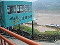
Badong Port passenger funicular

A coal barge on the Yangtze
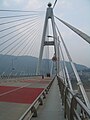
On the Badong Bridge, which carries G209 across the Yangtze
Government offices of Baishawan village, in Xiqiuwan Township


References[]
- ^ Jump up to: a b c 巴东县历史沿革 [Badong County Historical Development] (in Chinese). XZQH.org. 6 August 2014. Retrieved 24 January 2019.
1996年初,巴东县面积3219平方千米,{...}2010年第六次人口普查,巴东县常住总人口420840人,其中:信陵镇60831人,东壤[sic]口镇22771人,沿渡河镇39607人,官渡口镇44157人,茶店子镇26510人,绿葱坡镇22533人,大支坪镇16901人,野三关镇61233人,水布垭镇39011人,清太坪镇31645人,溪丘湾乡36477人,金果坪乡19164人。
- ^ 行政区划 [Administrative Divisions] (in Chinese). Badong County People's Government. Retrieved 24 January 2019.
1.官渡口镇{...}2.水布垭镇{...}3.绿葱坡镇{...}4.金果坪乡{...}5.茶店子镇{...}6.野三关镇{...}7.溪丘湾乡{...}8.信陵镇{...}9.清太坪镇{...}10.沿渡河镇{...}11.东瀼口镇{...}12.大支坪镇{...}
- ^ 2017年统计用区划代码和城乡划分代码:巴东县 [2017 Statistical Area Numbers and Rural-Urban Area Numbers: Badong County] (in Chinese). National Bureau of Statistics of the People's Republic of China. 2017. Retrieved 24 January 2019.
统计用区划代码 名称 422823100000 信陵镇 422823101000 东瀼口镇 422823102000 沿渡河镇 422823103000 官渡口镇 422823104000 茶店子镇 422823105000 绿葱坡镇 422823106000 大支坪镇 422823107000 野三关镇 422823108000 水布垭镇 422823109000 清太坪镇 422823200000 溪丘湾乡 422823201000 金果坪乡
External links[]
| Wikimedia Commons has media related to Badong County. |
| Authority control |
|
|---|
- Badong County
- County-level divisions of Hubei