Changshou District
Changshou
长寿区 Changshow | |
|---|---|
 | |
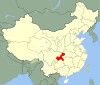
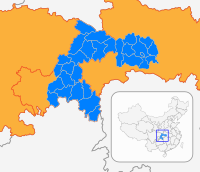
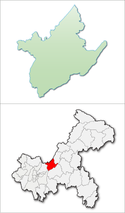 Changshou District in Chongqing | |
| Country | People's Republic of China |
| Municipality | Chongqing |
| Time zone | UTC+8 (China Standard) |
Changshou (simplified Chinese: 长寿区; traditional Chinese: 長壽區; pinyin: Chángshòu Qū) is a district in Chongqing, China, located by the Yangtze river, with a history spanning several thousand years. Changshou is 80 km (50 mi) from the Yuzhong District of downtown Chongqing.
Administrative divisions[]
Changshou District administers 14 townships and 4 subdistricts,[1] with a total area of 1,415 km2 (546 sq mi).
| Name | Chinese (S) | Hanyu Pinyin | Population (2010)[2] | Area (km2) |
|---|---|---|---|---|
| 凤城街道 | Fèngchéng Jiēdào | 175,576 | 72.7 | |
| 晏家街道 | Yànjiā Jiēdào | 72,825 | 95 | |
| 江南街道 | Jiāngnán Jiēdào | 21,509 | 68.8 | |
| 渡舟街道 | Dùzhōu Jiēdào | 51,888 | 114 | |
| 八颗街道 | Bākē Jiēdào | 36,698 | 99.25 | |
| 新市街道 | Xīnshì Jiēdào | 21,578 | 37 | |
| Linfeng town | 邻封镇 | Línfēng Zhèn | 23,868 | 55 |
| town | 但渡镇 | Dàndù Zhèn | 14,497 | 57 |
| Yunji town | 云集镇 | Yúnjí Zhèn | 27,564 | 115.32 |
| town | 长寿湖镇 | Chángshòuhú Zhèn | 37,839 | 104.53 |
| Shuanglong town | 双龙镇 | Shuānglóng Zhèn | 29,213 | 57 |
| Longhe town | 龙河镇 | Lónghé Zhèn | 35,561 | 89.9 |
| town | 石堰镇 | Shíyàn Zhèn | 48,193 | 101.78 |
| Yuntai town | 云台镇 | Yúntái Zhèn | 40,328 | 87.32 |
| Haitang town | 海棠镇 | Hǎitáng Zhèn | 24,252 | 46 |
| Gelan town | 葛兰镇 | Gélán Zhèn | 55,938 | 47.5 |
| Honghu town | 洪湖镇 | Hónghú Zhèn | 30,426 | 103.65 |
| town | 万顺镇 | Wànshùn Zhèn | 22,256 | 57 |
History[]
Changshou has a history of 2300 years.
- In 316 BC, a Zhi county was established.
- In 226 AD, it was renamed Jiangzhou county.
- In 519, it was renamed as Lewen county.
- In 1362, it was renamed as Changshou county.
- In 1959, Changshou county was put under the administration of Chongqing city.
- In 2002, Changshou city was changed into Changshou district, Chongjin, a county-level division of Chongqing.
Population[]
Until the end of 2013, there are 369321 households, the total population is 906732. Among them, the non-agriculture population is 310531, agriculture population is 596201.[3]
Geography[]
Changshou is located in 106°49’22” E – 107°27’30”E of longitude and 29°43’ N – 30°12’30”N of latitude, and is 56.56 km (35.14 mi) wide from south to north, and 57.5 km (35.7 mi) long from east to west. The altitude in the area is between 154 to 1,034.2 m (505 to 3,393 ft)[citation needed]. Changshou is classified as shallow hill area, slopes in the area are relatively smooth.
Climate[]
This section does not cite any sources. (June 2018) |
Its climate belongs to subtropic monsoon weather style, with an annual average temperature of 18.1 °C (64.6 °F), annual accumulated temperature of 6000 °C, monthly average temperature of 6.7 °C (44.1 °F) in January, 28.4 °C (83.1 °F) in July, annual total rainfall of 1,152.3 mm (45.37 in), annual sunshine duration of 1221 hours and frost-free period of 331 days.
Transportation[]
Chongqing- Fuling Freeway and other two freeways are intersected in Changshou area. Chongqing- Wanzhou Railway is under construction to provide transportation for businesses and tourists. Changshou has two Yangtze River crossings, a road and a railway bridge.
Changshou District is 50 kilometers away from Chongqing Jiangbei International Airport.[citation needed]
Economy[]
- In 2006, the total annual GDP was CNY 8.8 billion.
Tourism[]
Famous tourist attractions include Lake Changshou, which is a man-made lake of 60 km2 (23 sq mi); Changshou Ancient Town; Puti Mountain and Dongling Temple.
Mount Puti is a tourist attraction in the district.
Special Local Product[]
- Changshou Grapefruit
- Changshou Rice Noodle
- Blood Tofu
Sister city[]
This section is empty. You can help by . (July 2010) |
Notes[]
- ^ "Archived copy". Archived from the original on 2018-10-06. Retrieved 2014-01-22.CS1 maint: archived copy as title (link)
- ^ shi, Guo wu yuan ren kou pu cha ban gong; council, Guo jia tong ji ju ren kou he jiu ye tong ji si bian = Tabulation on the 2010 population census of the people's republic of China by township / compiled by Population census office under the state; population, Department of; statistics, employment statistics national bureau of (2012). Zhongguo 2010 nian ren kou pu cha fen xiang, zhen, jie dao zi liao (Di 1 ban. ed.). Beijing Shi: Zhongguo tong ji chu ban she. ISBN 978-7-5037-6660-2.
- ^ http://cs.cq.gov.cn/zjcs/12/
External links[]
- Government website of Changshou (in Simplified Chinese)

Coordinates: 29°57′48″N 107°06′47″E / 29.9633°N 107.113°E

| show Authority control |
|---|
This Chongqing location article is a stub. You can help Wikipedia by . |
- Changshou District
- Districts of Chongqing
- Southwest China geography stubs
- Chongqing stubs