Banan District, Chongqing
Banan
巴南区 | |
|---|---|
 | |
 Banan District in Chongqing | |
| Country | People's Republic of China |
| Municipality | Chongqing |
| Time zone | UTC+8 (China Standard) |
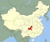
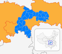
Banan District (simplified Chinese: 巴南区; traditional Chinese: 巴南區; pinyin: Bānán Qū), formerly Ba County, is a district of Chongqing municipality.
Geography and Climate[]
Banan, situated in the south of Sichuan Basin, has a diversity of terrains including mountains, hills, wetlands and flood beds. The lowest point of the district is on its northern border with Nanan District, at an altitude of 154 meters. The highest point is the top of Fangdou Mountain in the southeast of the district, at an altitude of 1132.6 meters.
The climate of Banan is humid subtropical climate, typically found in Southern China and characterized by hot and humid summers, and mild winters. The average temperature of the year is 18.7 Celsius degrees, but sometimes the temperature can get as low as -1 degree in winter and as high as 41 degrees in summer. The annual precipitation of Banan usually fluctuates between 1000 and 1200 millimeters, with abundant rainfall from May to July.
Administrative divisions[]
| Name | Chinese (S) | Hanyu Pinyin | Population (2010)[1] | Area (km2) |
|---|---|---|---|---|
| 龙洲湾街道 | Lóngzhōuwān Jiēdào | 42,786 | 39.5 | |
| 鱼洞街道 | Yúdòng Jiēdào | 171,363 | 55.6 | |
| Huaxi Subdistrict | 花溪街道 | Huāxī Jiēdào | 130,637 | 47.61 |
| 李家沱街道 | Lǐjiātuó Jiēdào | 89,213 | 4.25 | |
| 南泉街道 | Nánquán Jiēdào | 53,056 | 84.26 | |
| 一品街道 | YīpǐnJiēdào | 21,648 | 58.9 | |
| 南彭街道 | Nánpéng Jiēdào | 46,786 | 126.9 | |
| 惠民街道 | Huìmín Jiēdào | 23,017 | 63.21 | |
| town | 界石镇 | Jièshí Zhèn | 47,636 | 64.13 |
| town | 安澜镇 | Ānlán Zhèn | 31,546 | 122.42 |
| town | 跳石镇 | Tiàoshí Zhèn | 28,825 | 136 |
| town | 木洞镇 | Mùdòn Zhèn | 36,704 | 104.3 |
| town | 双河口镇 | Shuānghékǒu Zhèn | 12,739 | 60.45 |
| town | 麻柳嘴镇 | Máliǔzuǐ Zhèn | 18,847 | 79.34 |
| town | 丰盛镇 | Fēngshèng Zhèn | 13,649 | 69 |
| town | 二圣镇 | Èrshèng Zhèn | 16,461 | 60 |
| town | 东泉镇 | Dōngquán Zhèn | 29,134 | 122.7 |
| town | 姜家镇 | Jiāngjiā Zhèn | 16,518 | 80.36 |
| town | 天星寺镇 | Tiānxīngsì Zhèn | 8,383 | 46.1 |
| town | 接龙镇 | Jiēlóng Zhèn | 48,018 | 188.15 |
| town | 石滩镇 | Shítān Zhèn | 11,295 | 52.09 |
| town | 石龙镇 | Shílóng Zhèn | 20,431 | 106.31 |
Transportation[]
Metro[]
Banan is currently served by two metro lines operated by Chongqing Rail Transit:
- Line 2 - , Yudong 3
- Line 3 - Yudong 2, Jinzhu, Yuhulu, Xuetangwan, Dashancun, Chaoyouchang, Chalukou, Jiugongli, Qilong, Bagongli
References[]
- ^ shi, Guo wu yuan ren kou pu cha ban gong; council, Guo jia tong ji ju ren kou he jiu ye tong ji si bian = Tabulation on the 2010 population census of the people's republic of China by township / compiled by Population census office under the state; population, Department of; statistics, employment statistics national bureau of (2012). Zhongguo 2010 nian ren kou pu cha fen xiang, zhen, jie dao zi liao (Di 1 ban. ed.). Beijing Shi: Zhongguo tong ji chu ban she. ISBN 978-7-5037-6660-2.

Coordinates: 29°15′27.54″N 106°41′37.41″E / 29.2576500°N 106.6937250°E

This Chongqing location article is a stub. You can help Wikipedia by . |
- Districts of Chongqing
- Southwest China geography stubs
- Chongqing stubs