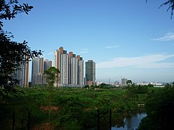
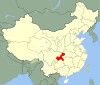
Dazu District
Dazu
大足区 | |
|---|---|
 | |
 | |
 Dazu in Chongqing | |
| Country | People's Republic of China |
| Municipality | Chongqing |
| Area | |
| • Total | 1,433 km2 (553 sq mi) |
| Population (2010) | |
| • Total | 721,300 |
| • Density | 500/km2 (1,300/sq mi) |
| Time zone | UTC+8 (China Standard) |
Dazu District (simplified Chinese: 大足区; traditional Chinese: 大足區; pinyin: Dàzú Qū) is a district of Chongqing, China, bordering Sichuan province to the northwest. It is where the famous Dazu Rock Carvings, a UNESCO World Heritage Site, is located. Dazu Lotus Manor is a tourist attraction with many lotus plants, some bred from seeds sent to space.
History[]
In the late 19th century, Dazu was the site of major violence led by the Gelaohui against Chinese Christians who were accused of controlling the local coal market, and resented for the large church built between two major temples devoted to on the main market square. This church was destroyed multiple times in the 1880s and 1890s. The violence displaced thousands of people, with one incident, in 1890 leading to the deaths of 12 Christians who refused to bow to statues of Lingguan.[1][2]
In October 2011, Dazu County and Shuangqiao District were merged to form the new Dazu District.[3]
Administrative divisions[]
| Name | Chinese (S) | Hanyu Pinyin | Population (2010)[4] | Area (km2) |
|---|---|---|---|---|
| 龙岗街道 | Lónggǎng Jiēdào | 74,605 | 43.83 | |
| 棠香街道 | Tángxiāng Jiēdào | 66,325 | 60.2 | |
| 龙滩子街道 | Lóngtānzi Jiēdào | 13,258 | ||
| town | 龙水镇 | Lóngshuǐ Zhèn | 121,609 | 81 |
| town | 智凤镇 | Zhìfèng Zhèn | 28,467 | 67.17 |
| town | 宝顶镇 | Bǎodǐng Zhèn | 17,591 | 63.78 |
| town | 中敖镇 | Zhōng'áo Zhèn | 31,118 | 113.62 |
| town | 三驱镇 | Sānqū Zhèn | 28,563 | 76 |
| town | 宝兴镇 | Bǎoxìng Zhèn | 18,963 | 51.49 |
| town | 玉龙镇 | Yùlóng Zhèn | 16,072 | 51.07 |
| town | 石马镇 | Shímǎ Zhèn | 22,820 | 51.6 |
| town | 拾万镇 | Shíwàn Zhèn | 16,103 | 49 |
| town | 回龙镇 | Huílóng Zhèn | 12,974 | 49 |
| town | 金山镇 | Jīnshān Zhèn | 11,034 | 38 |
| town | 万古镇 | Wàngǔ Zhèn | 28,871 | 66.5 |
| 国梁镇 | Guóliáng Zhèn | 11,392 | 38.97 | |
| Town | 雍溪镇 | Yōngxī Zhèn | 15,213 | 39.92 |
| town | 珠溪镇 | Zhūxī Zhèn | 34,113 | 83 |
| town | 龙石镇 | Lóngshí Zhèn | 10,477 | 31.4 |
| town | 邮亭镇 | Yóutíng Zhèn | 44,363 | 107 |
| Tieshan town | 铁山镇 | Tiěshān Zhèn | 15,669 | 59.97 |
| town | 高升镇 | Gāoshēng Zhèn | 13,995 | 48 |
| town | 季家镇 | Jìjiā Zhèn | 10,941 | 53.6 |
| town | 古龙镇 | Gǔlóng Zhèn | 6,442 | 18 |
| town | 高坪镇 | Gāopíng Zhèn | 13,523 | 46 |
| town | 双路镇 | Shuānglù Zhèn | 26,582 | |
| town | 通桥镇 | Tōngqiáo Zhèn | 10,276 | 18.5 |
References[]
- ^ Duara, Prasenjit (1996). Rescuing history from the nation : questioning narratives of modern China (Pbk. ed.). Chicago: University of Chicago Press. p. 122. ISBN 0-226-16722-4.
- ^ Bickers, Henriot, eds. (2017). New frontiers : imperialism's new communities in East Asia, 1842-1953 (MSI ed.). Manchester, UK. pp. 81–83. ISBN 1526119749.CS1 maint: multiple names: authors list (link) CS1 maint: extra text: authors list (link)
- ^ 重庆调整部分行政区划:4区(县)并为2区 [Chongqing adjusts administrative areas: 4 districts/counties merge into 2 districts] (in Chinese). 163 News. Archived from the original on 2011-10-31. Retrieved 2011-11-10.
- ^ shi, Guo wu yuan ren kou pu cha ban gong; council, Guo jia tong ji ju ren kou he jiu ye tong ji si bian = Tabulation on the 2010 population census of the people's republic of China by township / compiled by Population census office under the state; population, Department of; statistics, employment statistics national bureau of (2012). Zhongguo 2010 nian ren kou pu cha fen xiang, zhen, jie dao zi liao (Di 1 ban. ed.). Beijing Shi: Zhongguo tong ji chu ban she. ISBN 978-7-5037-6660-2.
External links[]
| Wikimedia Commons has media related to Dazu District. |

Coordinates: 29°42′N 105°43′E / 29.700°N 105.717°E

This Chongqing location article is a stub. You can help Wikipedia by . |
- County-level divisions of Chongqing
- Southwest China geography stubs
- Chongqing stubs