Wuxi County
Wuxi
巫溪县 Wuki | |
|---|---|
 | |
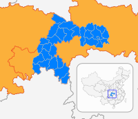
 Location of Wuxi County in Chongqing | |
| Coordinates (Wuxi County government): 31°23′55″N 109°34′12″E / 31.3986°N 109.5700°ECoordinates: 31°23′55″N 109°34′12″E / 31.3986°N 109.5700°E | |
| Country | People's Republic of China |
| Municipality | Chongqing |
| County seat | (城厢镇) |
| Government | |
| • Type | County |
| • CPC Secretary | (唐德祥) |
| • Mayor | Luo Cheng (罗成) |
| Area | |
| • County | 4,029.8 km2 (1,555.9 sq mi) |
| Population (2010)[1] | |
| • County | 414,073 |
| • Density | 100/km2 (270/sq mi) |
| • Urban | 163,000 |
| Time zone | UTC+8 (China Standard) |
| Postal code | 405800 |
| Area code(s) | 023 |
| GDP[2] | 2013 |
| - Total | CNY9.01 billion US$1.45 billion |
| - Per capita | CNY17,012 US$2,744 |
| - Growth | |
| HDI | 0.758 |
| County flower | Peach |
| Website | http://wx.cq.gov.cn/ |
Wuxi County (Chinese: 巫溪县; pinyin: Wūxī Xiàn) is a county of Chongqing Municipality, People's Republic of China, bordering Shaanxi to the north and Hubei to the northeast and east. Sitting at the upper reaches of Daning River and the southern slopes of the central Daba Mountains. It is best known for its scenic views and its preserved witchcraft culture.
Wuxi County is noted as a major tourism site of Chongqing.
Administrative divisions[]
Wuxi County has 2 subdistricts and numerous towns and townships:[1][3][4][5]
| Subdistricts | Towns | Townships |
|---|---|---|
Former township:
Geography[]

The vast majority of Wuxi's land area is mountainous. With a wet abundant precipitation, Wuxi County is suitable for many plants to grow, the local products are medicine nectar, starch, bacon, dried fruit, vegetables and antler.
| hideClimate data for Wuxi County (1971−2000) | |||||||||||||
|---|---|---|---|---|---|---|---|---|---|---|---|---|---|
| Month | Jan | Feb | Mar | Apr | May | Jun | Jul | Aug | Sep | Oct | Nov | Dec | Year |
| Average high °C (°F) | 8.6 (47.5) |
10.8 (51.4) |
15.3 (59.5) |
21.3 (70.3) |
25.6 (78.1) |
28.1 (82.6) |
31.4 (88.5) |
32.1 (89.8) |
26.6 (79.9) |
21.0 (69.8) |
15.7 (60.3) |
10.2 (50.4) |
20.6 (69.0) |
| Average low °C (°F) | 3.3 (37.9) |
4.8 (40.6) |
8.3 (46.9) |
13.1 (55.6) |
17.3 (63.1) |
20.4 (68.7) |
23.0 (73.4) |
22.6 (72.7) |
19.1 (66.4) |
14.4 (57.9) |
9.6 (49.3) |
5.0 (41.0) |
13.4 (56.1) |
| Average precipitation mm (inches) | 17.8 (0.70) |
17.8 (0.70) |
49.4 (1.94) |
109.4 (4.31) |
163.3 (6.43) |
205.2 (8.08) |
211.8 (8.34) |
153.1 (6.03) |
179.1 (7.05) |
109.1 (4.30) |
52.1 (2.05) |
23.6 (0.93) |
1,291.7 (50.86) |
| Average precipitation days (≥ 0.1 mm) | 9.6 | 9.2 | 12.3 | 14.7 | 15.7 | 15.5 | 13.1 | 11.5 | 14.1 | 14.3 | 11.6 | 10.2 | 151.8 |
| [citation needed] | |||||||||||||
Economy[]
Total economy performance in 2013 is good and growth rate is accelerating. Total GDP is 9.01 billion yuan in 2013.
Farming in Wuxi County[]
Major products include rice, corn, potato, sweet potato, cotton, broccoli, cauliflower, spinach, carrot and soybean.
Wuxi Industry Park[]
Manufacturing is the most important economy sector of Wuxi County, they are separately located in several industrial park of Wuxi county. One industry park is in Fenghuang town(凤凰), another one is in Jianshan Town(尖山), the third industrial park is in Ninggang. They all are regulated by Wuxi Government.
Banking in Wuxi County[]
Agricultural Bank of China is the most popular bank in Wuxi County with Postal Savings Bank of China come to the second place under the regulation of People's Bank of China of Wuxi County
Mining in Wuxi County[]
Mining is still an important part of the economy of Wuxi County, The major areas of production in 2010 were coal, iron ore, natural gas, salt and zinc.
Tourism[]
Tourism is a large industry in Wuxi county, with a number of tourism companies flourishing in recent years. The county's natural resources are some of the best preserved in Chongqing.
- ([1])
- Chinese New Year at Wuxi
- Daning River
Transportation[]
Massive infrastructure programs started in 2008, like Wuxi-Yunyan highway, Wuxi-Fengjie highway and Wuxi-Zhenping highway with anticipation of completion in 2013 and that will be connected with other China National Highways
There is also a plan under consideration about building an airport in Wuxi County to serve the region across Shaanxi province, Sichuan province also other neighbouring provinces like Hubei, Guizhou, Hunan.
The started bus service to Guangdong province and Shanghai in early 2009 while serves domestic transportation.
Education[]
Elementary Schools[]
- (城厢小学)
- (环城小学)
- (珠海实验小学)
Middle and High Schools[]
Vocational Schools[]
- (环城职教中心)
- (文峰职教中心)
References[]
- ^ Jump up to: a b c 巫溪县历史沿革 [Wuxi County Historical Development] (in Chinese). XZQH.org. 29 June 2016. Retrieved 3 March 2019.
1996年,巫溪县面积4029.8平方千米,{...}2010年第六次人口普查,巫溪县常住总人口414073人,其中:城厢镇89080人,凤凰镇14574人,宁厂镇5068人,上磺镇25648人,古路镇22331人,文峰镇31338人,徐家镇13461人,白鹿镇14870人,尖山镇17334人,下堡镇14458人,峰灵镇15517人,塘坊镇17065人,朝阳镇13524人,田坝镇9568人,通城镇11741人,胜利乡7328人,菱角乡13364人,大河乡8341人,天星乡3121人,长桂乡4770人,蒲莲乡9443人,鱼鳞乡5336人,乌龙乡5993人,中岗乡14567人,花台乡5028人,兰英乡2667人,双阳乡2111人,中梁乡3861人,天元乡5663人,土城乡6245人,红池坝经济开发区658人。2010年11月22日,市政府(渝府[2010]115号)批复同意巫溪县政府驻地由城厢镇人民街88号迁至城厢镇马镇坝广场东路8号。2010年12月24日,市政府(渝府[2010]121号)批复同意巫溪县调整城厢镇行政区域范围,设立宁河街道、柏杨街道。至此,全县辖2个街道、15个镇、15个乡。2015年12月28日,市政府(渝府〔2015〕71号)批复同意撤销土城乡、蒲莲乡、菱角乡,设立土城镇、蒲莲镇、菱角镇。调整后,巫溪县辖2个街道、18个镇、12个乡。
- ^ 上海人均GDP超北京全国最高. Dongfang Daily (in Chinese). 20 January 2012.
- ^ 走进巫溪 (in Chinese). Retrieved 3 March 2019.
走进巫溪{...}中梁乡{...}红池坝镇{...}鱼鳞乡{...}徐家镇{...}下堡镇{...}乌龙乡{...}文峰镇{...}土城镇{...}通城镇{...}田坝镇{...}天元乡{...}天星乡{...}塘坊镇{...}双阳乡{...}
- ^ 走进巫溪 (in Chinese). Retrieved 3 March 2019.
走进巫溪{...}胜利乡{...}上磺镇{...}蒲莲镇{...}宁厂镇{...}菱角镇{...}兰英乡{...}尖山镇{...}花台乡{...}古路镇{...}凤凰镇{...}峰灵镇{...}大河乡{...}城厢镇{...}朝阳镇{...}白鹿镇{...}
- ^ 2018年统计用区划代码和城乡划分代码:巫溪县 [2018 Statistical Area Numbers and Rural-Urban Area Numbers: Wuxi County] (in Chinese). National Bureau of Statistics of the People's Republic of China. 2018. Retrieved 3 March 2019.
统计用区划代码 名称 500238001000 宁河街道办事处 500238002000 柏杨街道办事处 500238100000 城厢镇 500238101000 凤凰镇 500238102000 宁厂镇 500238103000 上磺镇 500238104000 古路镇 500238105000 文峰镇 500238106000 徐家镇 500238107000 白鹿镇 500238108000 尖山镇 500238109000 下堡镇 500238110000 峰灵镇 500238111000 塘坊镇 500238112000 朝阳镇 500238113000 田坝镇 500238114000 通城镇 500238115000 菱角镇 500238116000 蒲莲镇 500238117000 土城镇 500238118000 红池坝镇 500238204000 胜利乡 500238207000 大河乡 500238208000 天星乡 500238210000 长桂乡 500238226000 鱼鳞乡 500238227000 乌龙乡 500238237000 花台乡 500238239000 兰英乡 500238240000 双阳乡 500238242000 中梁乡 500238243000 天元乡 500238400000 红池坝经济开发区
External links[]
- Wuxi County
- County-level divisions of Chongqing


