Fellhorn
| Fellhorn | |
|---|---|
 The Fellhorn in summer | |
| Highest point | |
| Elevation | 2,038 m (6,686 ft) |
| Prominence | 230 m (750 ft) |
| Isolation | 1.9 km (1.2 mi) |
| Coordinates | 47°21′02″N 10°13′03″E / 47.35056°N 10.21750°ECoordinates: 47°21′02″N 10°13′03″E / 47.35056°N 10.21750°E |
| Geography | |
 Fellhorn Location in the Alps | |
| Location | Germany / Austria |
| Parent range | Allgäu Alps |
| Climbing | |
| Easiest route | Hike |

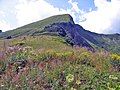
The Fellhorn (2,038 metres (6,686 ft)) is a mountain in the "Allgäu Alps" near Oberstdorf, Germany, on the border with Austria. It is known for its fields of alpenroses (Rhododendron ferrugineum). According to Austrian sources the mountain is 2,039 m above sea level (AA).[1]
Access[]
In 1972, a gondola lift, the "Fellhorn Lift", was built that runs up the mountain from the Stillach valley. Its top station is at 1,967 metres. There is also a lift connection to the . The cross-border Fellhorn/Kanzelwand Ski Region has 24 kilometres of slopes and 14 lifts.[2]
Gallery[]

The Fellhorn in winter
The summit from the east


References[]
- ^ Bundesamt für Eich- und Vermessungswesen Austria: Austrian Map online (Austrian 1:50,000 map series) Archived 2013-09-27 at the Wayback Machine. Retrieved 19 January 2011.
- ^ Skigebiet Fellhorn/Kanzelwand, retrieved 5 April 2012
External links[]
| Wikimedia Commons has media related to Fellhorn. |
| Authority control |
|
|---|
Categories:
- Mountains of Bavaria
- Mountains of Vorarlberg
- Austria–Germany border
- International mountains of Europe
- Mountains of the Alps
- Allgäu Alps