Oberstdorf
Oberstdorf | |
|---|---|
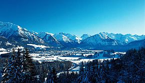
 Oberstdorf village view | |
 Coat of arms | |
show Location of Oberstdorf within Oberallgäu district | |
 Oberstdorf | |
| Coordinates: 47°25′N 10°17′E / 47.417°N 10.283°ECoordinates: 47°25′N 10°17′E / 47.417°N 10.283°E | |
| Country | Germany |
| State | Bavaria |
| Admin. region | Swabia |
| District | Oberallgäu |
| Government | |
| • Mayor (2020–26) | Klaus King[1] |
| Elevation | 815 m (2,674 ft) |
| Population (2020-12-31)[2] | |
| • Total | 9,572 |
| Time zone | UTC+01:00 (CET) |
| • Summer (DST) | UTC+02:00 (CEST) |
| Postal codes | 87561 |
| Website | Official website |


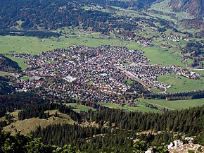
Oberstdorf (Low Alemannic: Oberschdorf) is a municipality and skiing and hiking town in Germany, located in the Allgäu region of the Bavarian Alps. It is the southernmost settlement in Germany and one of its highest towns.
At the center of Oberstdorf is a church whose tall spire serves as a landmark for navigating around town. The summits of the Nebelhorn and Fellhorn provide dramatic panoramic views of the alps. The Nebelhorn can be reached with a big cable car. Visitors can ride a unique diagonal elevator to the top of the Heini-Klopfer-Skiflugschanze.
Geography[]

Administrative divisions[]
Oberstdorf consists of the village of Oberstdorf (813 metres above sea level, survey point by the Roman Catholic church) and five other villages:
- Kornau , 915 m. In the vicinity is the and the Chapel of St. Fabian and St. Sebastian which is rich in art treasures.
- In Reichenbach (population: 226) is the 450-year-old Chapel of St. James and the Moorwasser swimming pool.
- The little hamlet of Rubi has 175 inhabitants.
- Typical of Schöllang are the farm houses around the Baroque onion tower of the parish church. In the vicinity is the 1531 .
- The village of takes its name from trees called Bergkiefer. The village lies on a terrace above the Breitach stream. Tiefenbach has a centuries-old spa tradition thanks to its sulphur spring. As early as the late 15th century counts and other high-ranking people convalesced here to cure their illnesses.
Valleys[]
There is a large number of valleys in the area around Oberstdorf, many of which are not only scenic, but are often starting points for walks in the mountains. The following list shows the main valleys together with their side valleys:
- Breitach
- Stillach (Stillachtal or Birgsautal)
- Rappenalpbach (Rappenalptal)
- Warmatsgundbach (Warmatsgundtal)
- Iller
- Oybach (Oytal)
- Trettach
Oytal and Dietersbachtal are separated by the Höfats and Rauheck. , Germany's highest village, lies at the entrance to the Dietersbachtal.
The Rappenalptal is the longest and runs from Germany's southernmost village, , past the , Germany's southernmost point. At the end of the valley the Schrofen Pass leads to Austria.
Mountains[]
The Allgäu Alps in the area around Oberstdorf attain heights of over 2,600 metres and belong to the Northern Limestone Alps. The best known summits in Oberstdorf are:[3]
- Fellhorn 2,038 m (Blumenberg of the Allgäu)
- Himmelschrofen 1,791 m
- Höfats 2,259 m (the most prominent Allgäu "grass mountain")
- Kratzer 2,427 m
- Großer Krottenkopf 2,656 m (highest mountain of the Allgäu Alps)
- Mädelegabel 2,645 m (lies on the Heilbronn Way)
- Nebelhorn 2,224 m (with cable car)
- Rubihorn 1,957 m (local mountain)
- Schattenberg 1,845 m (by the eponymous ski jump)
- Schneck 2,268 m (unique shape)
- Trettachspitze 2,595 m
- Hoher Ifen 2,230 m
Lakes[]
There are numerous lakes at various heights around Oberstdorf:
- , drinking water quality, in the Trettach valley
- , east of the Großer Daumen
- , bathing lake in the Stillach valley
- and
- Guggersee by the
- Hermannskarsee between the Großer Krottenkopf and the Marchspitze
- Koblatsee in the Nebelhorn area
- Laufbichelsee also on the Koblat of the Nebelhorn
- on the Krappberg
- Rappensee at 2,047 m
- by the middle station of the Fellhornbahn
- above the Oytal
Main sights[]
- St. Anna-Kapelle, a chapel in Rohrmoos
- 17th and 18th century farmhouses
- Breitachklamm near Tiefenbach, a gorge created by the river Breitach
- Heini-Klopfer-Skiflugschanze, the third largest ski flying hill in the world
- Schattenbergschanze, a ski jumping hill (the opening of the Four Hills Tournament)
History[]
Findings show that the Oberstdorf area was already inhabited from the Stone Age to the Roman Empire. When the Romans had abandoned the area east of the Upper Rhine and north of the Upper Rhine in the 3rd century, various Germanic groups migrated into the area, which were later called Alemanni.[4]
Oberstdorf was first mentioned in 1141. King Maximilian, the later emperor, granted Oberstdorf in 1495 the right to hold a market and the High Court.[5] In 1518 Count Hugo of Montfort built a spa in Tiefenbach at the sulphur spring, which is regarded as a precursor of today's spa facility.[6] During World War II the mountains around the village were used to train mountain troops of the Wehrmacht. At the end of the war French and Mexican troops were stationed there.
Sports[]
In December, before every New Year, Oberstdorf hosts the first part of the ski jumping Four Hills Tournament on the Schattenberg large hill. There is also a ski flying hill, Heini-Klopfer-Skiflugschanze, about seven kilometres to the south. ABC's Wide World of Sports famously featured the Oberstdorf ski flying hill when Vinko Bogataj fell during his jump in 1970, thus becoming known as "The Agony of Defeat".
Oberstdorf hosted the Nordic skiing World Championships in 1987, 2005 and 2021. The town has also hosted several stages of the Tour de Ski, a cross-country skiing stage event.
Germany's modern figure skating center was built on the outside of the town. It has three covered rinks and some of them are accessible to the public, for recreational skating. It is a popular destination with European skaters for training camps.[7]
Oberstdorf hosts the annual Nebelhorn Trophy figure skating competition and has hosted the German Figure Skating Championships twelve times. It has also hosted the 1982, 2000, and 2007 World Junior Figure Skating Championships. One of the two ISU (for skaters aged 28 and older) is held in Oberstdorf each May.[8]
Mountain bikers start their Transalp tour in Oberstdorf on the Schrofen Pass to Riva del Garda.[9]
Notable people[]
- Andreas Heckmair, who participated in the first ascent of the North Face of the Eiger in 1938 lived in Oberstdorf until his death in 2005.
- Gertrud von Le Fort (1876-1971) author, lived in Oberstdorf from 1925 till her death on 1 Nov 1971
- Toni Steurer, athlete
- Chonrad Stoeckhlin (1549–1587), German herdsman who was accused and executed for witchcraft
- Friedrich-Jobst Volckamer von Kirchensittenbach (1894–1989), German general
- The 2010 German Vancouver Olympic Team Members Christina Geiger and Gina Stechert (both Alpine Skiing), David Speiser (Snowboard Cross), Johannes Rydzek (Nordic Combined), Nicole Fessel and Katrin Zeller (both Cross-Country Skiing), Daniel Herberg (Curling) and Michael Neumayer (Ski jumping) live in Oberstdorf
- Pavlo Skoropadskyi (Hetman of Ukraine)
- Thorsten Schäfer-Gümbel (born 1969), German politician (SPD)
- Karl Geiger (born 1993), Skijumper
- Maximilian Günther (born 1997), Racing driver
Sister cities[]
References[]
- ^ Liste der ersten Bürgermeister/Oberbürgermeister in kreisangehörigen Gemeinden, Bayerisches Landesamt für Statistik, 15 July 2021.
- ^ "Tabellenblatt "Daten 2", Statistischer Bericht A1200C 202041 Einwohnerzahlen der Gemeinden, Kreise und Regierungsbezirke". Bayerisches Landesamt für Statistik (in German). June 2021.
- ^ walking, cycling and ski touring map: Sheet 03 Oberstdorf, Kleinwalsertal (1:25,000). ISBN 978-3-8549-1231-6 (as at: 2009).
- ^ Landnahme der Alemannen (oberstdorf-lexikon.de)
- ^ Oberstdorf erhält das Marktrecht (1495) (oberstdorf-lexikon.de)
- ^ Unser altes Bad: Tiefenbach (oberstdorf-lexikon.de)
- ^ Flade, Tatjana (July 22, 2011). "Carolina Kostner Attends Camp In Oberstdorf, Germany". IFS Magazine. Archived from the original on September 10, 2011. Retrieved July 28, 2011.
- ^ "Adult Skating - International Skating Union". www.isu.org. Retrieved 2019-02-17.
- ^ Transalp on the Heckmair Route
External links[]
| Wikimedia Commons has media related to Oberstdorf. |
| show Towns and municipalities in Oberallgäu |
|---|

| show Authority control |
|---|
- Municipalities in Bavaria
- Ski areas and resorts in Germany
- Oberallgäu