Flaxweiler
This article needs additional citations for verification. (February 2013) |
Flaxweiler
Fluessweiler | |
|---|---|
Commune | |
 | |
 Coat of arms | |
 Map of Luxembourg with Flaxweiler highlighted in orange, and the canton in dark red | |
| Coordinates: 49°39′55″N 6°20′35″E / 49.6653°N 6.3431°ECoordinates: 49°39′55″N 6°20′35″E / 49.6653°N 6.3431°E | |
| Country | |
| Canton | Grevenmacher |
| Area | |
| • Total | 30.17 km2 (11.65 sq mi) |
| Area rank | 26th of 102 |
| Highest elevation | 387 m (1,270 ft) |
| • Rank | 63rd of 102 |
| Lowest elevation | 208 m (682 ft) |
| • Rank | 28th of 102 |
| Population (2018) | |
| • Total | 2,109 |
| • Rank | 70th of 102 |
| • Density | 70/km2 (180/sq mi) |
| • Density rank | 79th of 102 |
| Time zone | UTC+1 (CET) |
| • Summer (DST) | UTC+2 (CEST) |
| LU0001103 | |
| Website | flaxweiler.lu |

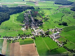
Flaxweiler (Luxembourgish: Fluessweiler) is a commune and small town in south-eastern Luxembourg. It is part of the canton of Grevenmacher.
As of 2001, the town of Flaxweiler, which lies in the north-west of the commune, has a population of 338. Other towns within the commune include Beyren, Gostingen, Niederdonven, and Oberdonven.
The Mayor of Flaxweiler is the chief executive of the administration of the Luxembourgish commune of Flaxweiler. The incumbent mayor is .
List of former mayors[]
| Name | Start | End |
|---|---|---|
| 1806 | 1810 | |
| 1810 | 1812 | |
| 1813 | 1816 | |
| 1816 | 1819 | |
| 1819 | 1825 | |
| (first time) | 1825 | 1830 |
| (first time) | 1830 | 1839 |
| (second time) | 1840 | 1848 |
| (second time) | 1848 | 1854 |
| 1854 | 1867 | |
| 1867 | 1876 | |
| 1876 | 1887 | |
| 1889 | 1895 | |
| 1895 | 1928 | |
| 1929 | 1944[note 1] | |
| 1945 | 1945 | |
| 1946 | 1965 | |
| 1966 | 1970 | |
| 1970 | 2005 | |
| 2005 | present (re-elected 2011)[1] |
Footnotes[]
- ^ Mayor in name only under Nazi occupation (1940 - 1944)
References[]
- ^ "Bestätigung für Théo Weirich" (in German). Luxembourg City, Luxembourg: Lëtzebuerger Journal. 9 October 2011. Retrieved 26 August 2012.[permanent dead link]
External links[]
 Media related to Flaxweiler at Wikimedia Commons
- (in French) Official website
- "Flaxweiler - Découvrir la commune" (in French). Commune of Flaxweiler. Archived from the original on 7 May 2011. Retrieved 25 August 2012.
| show Places adjacent to Flaxweiler |
|---|

| show Authority control |
|---|
This article related to the geography of Grevenmacher canton is a stub. You can help Wikipedia by . |
Categories:
- Flaxweiler
- Communes in Grevenmacher (canton)
- Towns in Luxembourg
- Luxembourg geography stubs