Flood basalt
This article needs additional citations for verification. (February 2019) |
A flood basalt is the result of a giant volcanic eruption or series of eruptions that covers large stretches of land or the ocean floor with basalt lava. Many flood basalts have been attributed to the onset of a hotspot reaching the surface of the earth via a mantle plume.[1] Flood basalt provinces such as the Deccan Traps of India are often called traps, after the Swedish word trappa (meaning "stairs"), due to the characteristic stairstep geomorphology of many associated landscapes. Michael R. Rampino and (1988) cited eleven distinct flood basalt episodes occurring in the past 250 million years, creating large volcanic provinces, lava plateaus, and mountain ranges.[2] However, more have been recognized such as the large Ontong Java Plateau,[3] and the Chilcotin Group, though the latter may be linked to the Columbia River Basalt Group. Large igneous provinces have been connected to five mass extinction events, and may be associated with bolide impacts.[4]
Formation[]
The formation and effects of a flood basalt depend on a range of factors, such as continental configuration, latitude, volume, rate, duration of eruption, style and setting (continental vs. oceanic), the preexisting climate, and the biota resilience to change.[5] Continental flood basalt provinces typically form on a timescale of 1 to 3 million years.[6][7]
One proposed explanation for flood basalts is that they are caused by the combination of continental rifting and its associated decompression melting, in conjunction with a mantle plume also undergoing decompression melting, producing vast quantities of a tholeiitic basaltic magma. These have a very low viscosity, which is why they 'flood' rather than form taller volcanoes. Another explanation is that they result from the release, over a short period, of melt that has accumulated in the mantle over a long period.[8]
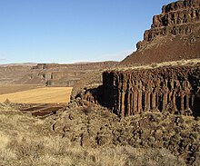
The Deccan Traps of central India, the Siberian Traps, and the Columbia River Plateau of western North America are three regions covered by prehistoric flood basalts. The Mesoproterozoic Mackenzie Large Igneous Province in Canada contains the Coppermine River flood basalts related to the Muskox layered intrusion. The maria on the Moon are additional, even more extensive, flood basalts. Flood basalts on the ocean floor produce oceanic plateaus.
The surface covered by one eruption can vary from around 200,000 km² (Karoo) to 1,500,000 km² (Siberian Traps). The thickness can vary[clarification needed]. Today these are smaller than the original volumes due to erosion.
Petrography[]

Flood basalts have tholeiite and olivine compositions (according to the classification of Yoder and Tilley). The composition of the basalts from the Paraná is fairly typical of that of flood basalts; it contains phenocrysts occupying around 25% of the volume of rock in a fine-grained matrix. These phenocrysts are pyroxenes (augite and pigeonite), plagioclases, opaque crystals such as titanium rich magnetite or ilmenite, and occasionally some olivine. Sometimes more differentiated volcanic products such as andesites, dacites and rhyodacites have been observed, but only in small quantities at the top of former magma chambers.
Structures[]
Subaerial flood basalts can be of two kinds :
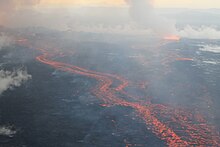
- with a smooth or twisted surface (Pāhoehoe) : very compact surface; vesicles (gas bubbles) are rare. Degassing was easy (magma maintained at a high temperature and more fluid in a chamber of a size such that confining pressures did not confine gases to the melt before expulsion). Such lava flows may form underground rivers; when degassing fractures and conduits are present, very large flows may reach the surface.
- with a chaotic surface (ʻAʻā) : the basalt flood is very rich in bubbles of gas, with an irregular, fragmental surface. Degassing was difficult (less fluid magma expelled from a rift with no chance of progressive expansion in a hot chamber; the degassing took place closer to the surface where the flow forms a crust which cracks under the pressure of the gases in the flow itself and during more rapid cooling).
In the Massif Central in Auvergne, France, there is a good example of chaotic lava flow, produced by eruptions from and Puy de Lassolas.
Large igneous provinces[]
Large Igneous Provinces (LIPs) were originally defined as including voluminous outpourings, predominantly of basalt, over geologically very short durations. This definition did not specify minimum size, duration, petrogenesis, or setting. A new attempt to refine classification focuses on size and setting. LIPs characteristically cover large areas and the great bulk of the magmatisim occurs in about less than 1 Ma. Principal LIPs in the ocean basins include Oceanic Volcanic Plateaus (OPs) and Volcanic Passive Continental Margins. Oceanic flood basalts are LIPs distinguished from oceanic plateaus by some investigators because they do not form morphologic plateaus, being neither flat-topped nor elevated more than 200 m above the seafloor. Examples include the Caribbean, Nauru, East Mariana, and Pigafetta provinces. Continental flood basalts (CFBs) or plateau basalts are continental manifestations, or traps referencing the step-like geomorphology of eroded flow layers. (e.g. Deccan Traps and Siberian Traps)[9]
Geochemistry[]

Geochemical analysis of the major oxides reveals a composition close to that of mid-ocean ridge basalts (MORB) but also close to that of ocean island basalts (OIB). These are in fact tholeiites with a silicon dioxide percentage close to 50%.
Two kinds of basaltic flood basalts can be distinguished :
- those poor in P2O5 and in TiO2, called low phosphorus and titanium
- those rich in P2O5 and in TiO2, called high phosphorus and titanium
The isotopic ratios 87Sr/86Sr and 206Pb/204Pb are different from that observed in general, which shows that the basalt flood magma was contaminated as it passed through the continental crust. It is this contamination that explains the difference between the two kinds of basalt mentioned above. The low phosphorus and titanium type has an excess of elements from the crust such as potassium and strontium.[citation needed]
The content in incompatible elements of flood basalts is lower than that of ocean island basalts, but higher than that of mid-ocean ridge basalts.[citation needed]

List of flood basalts[]
Representative continental flood basalts (also known as traps) and oceanic plateaus, arranged by chronological order, together forming a listing of large igneous provinces:[10]
| Name | Initial or peak activity (Ma ago) |
Surface area (in thousands of km2) |
Volume (in km3) |
Associated event |
|---|---|---|---|---|
| Chilcotin Group | 10 | 50 | 3300 | |
| Columbia River Basalt Group | 17 | 160 | 174,300 | Yellowstone Hotspot[11][12] |
| Ethiopia-Yemen Continental Flood Basalts | 31 | 600 | 350,000 | |
| North Atlantic Igneous Province (NAIP) | 56 (phase 2) | 1300 | 6,600,000 | Paleocene–Eocene Thermal Maximum[13] |
| Deccan Traps | 66 | 1500 | 3,000,000[citation needed] | Cretaceous–Paleogene extinction event |
| Caribbean large igneous province | 95 (main phase) | 2000 | 4,000,000 | Cenomanian-Turonian boundary event (OAE 2)[13] |
| Kerguelen Plateau | 119 | 1200 | Aptian extinction[14] | |
| Ontong-Java Plateau | 120 (phase 1) | 2000 | 80,000,000 | Selli event (OAE 1a)[13] |
| High Arctic Large Igneous Province (HALIP) | 120-130 | 1000 | Selli event (OAE 1a)[15] | |
| Paraná and Etendeka Traps | 132 | 1500 | 2,300,000 | |
| Karoo and Ferrar Provinces | 183 | 3000 | 2,500,000 | Toarcian turnover[16] |
| Central Atlantic Magmatic Province | 201 | 11000 | ~2–3 × 10⁶ | Triassic–Jurassic extinction event[17] |
| Siberian Traps | 251 | 7000 | 4,000,000 | Permian–Triassic extinction event[18] |
| Emeishan Traps | 265 | 250 | 300,000 | End-Capitanian extinction event[19] |
| Vilyuy Traps | 373 | 320 | Late Devonian extinction[20] | |
| Southern Oklahoma Aulacogen | 540 | 40 | 250,000 | End-Ediacaran event[21] |
| Arabian-Nubian Shield[citation needed] | 850 | 2700 | ||
| Mackenzie Large Igneous Province | 1270 | 2700 | 500,000[citation needed] |
In historic times, Eldgjá in 939 was in one of the largest (18 km3 on 800 km2)
See also[]
| Wikimedia Commons has media related to Flood basalts. |
- Large igneous province – Huge regional accumulation of igneous rocks
- Oceanic plateau – Relatively flat submarine region that rises well above the level of the ambient seabed
- Supervolcano – Volcano that has erupted 1000 cubic km in a single eruption
- Volcanic plateau – Plateau produced by volcanic activity
- List of flood basalt provinces – Continental flood basalts and oceanic plateaus
References[]
- ^ Mark A. Richards; Robert A. Ducan; Vincent E. Courtillot (1989). "Flood Basalts and Hot-Spot Tracks: Plume Heads and Tails". Science Magazine. 246: 103–107.
- ^ Michael R. Rampino; Richard B. Stothers (1988). "Flood Basalt Volcanism During the Past 250 Million Years". Science. 241 (4866): 663–668. Bibcode:1988Sci...241..663R. doi:10.1126/science.241.4866.663. PMID 17839077. S2CID 33327812. PDF via NASA[dead link]
- ^ Neal, C.; Mahoney, J.; Kroenke, L. (1997). "The Ontong Java Plateau" (PDF). Large Igneous Provinces: Continental, Oceanic, and Planetary Flood Volcanism, Geophysical Monograph 100. Archived from the original (PDF) on 2017-01-01.
- ^ Negi, J. G.; Agrawal, P. K.; Pandey, O. P.; Singh, A. P. (1993). "A possible K-T boundary bolide impact site offshore near Bombay and triggering of rapid Deccan volcanism". Physics of the Earth and Planetary Interiors. 76 (3–4): 189. Bibcode:1993PEPI...76..189N. doi:10.1016/0031-9201(93)90011-W.
- ^ David P.G. Bond; Paul B. Wignall (2014). "Large igneous provinces and mass extinctions: An update". GSA Special Papers. 505: 29–55. doi:10.1130/2014.2505(02). ISBN 9780813725055.
- ^ Self, S., A. Schmidt, and T. A. Mather. "Emplacement characteristics, time scales, and volcanic gas release rates of continental flood basalt eruptions on Earth." Geological Society of America Special Papers 505 (2014). "Most continental flood basalt provinces appear to have formed within 1–3 m.y."
- ^ "Stop Calling Flood Basalt Provinces a Single "Volcano" or "Eruption"". Discover Magazine. 2013. Retrieved 27 April 2020.
- ^ Foulger, G.R. (2010). Plates vs. Plumes: A Geological Controversy. Wiley-Blackwell. ISBN 978-1-4051-6148-0.
- ^ Winter, John (2010). Principles of Igneous and Metamorphic Petrology (2nd ed.). New York: Prentice Hall. pp. 301–302. ISBN 9780321592576.
- ^ Sur l'âge des trapps basaltiques (On the ages of flood basalt events); Vincent E. Courtillota & Paul R. Renneb; Comptes Rendus Geoscience; Vol: 335 Issue: 1, January, 2003; pp: 113–140
- ^ M.A. Richards, R.A. Duncan, V.E. Courtillot; Flood Basalts and Hot-Spot Tracks: Plume Heads and Tails; SCIENCE, VOL. 246 (1989) 103–108
- ^ Barbara P. Nash, Michael E. Perkins, John N. Christensen, Der-Chuen Lee, & A.N. Halliday; The Yellowstone hotspot in space and time: Nd and Hf isotopes in silicic magmas; Earth and Planetary Science Letters 247 (2006) 143–156
- ^ Jump up to: a b c David Bond; Paul Wignall. "Large igneous provinces and mass extinctions: An update" (PDF). p. 17. Archived from the original (PDF) on 2016-01-24.
- ^ Wallace, P. J.; Frey, F. A.; Weis, D.; Coffin, M. F. (2002). "Origin and Evolution of the Kerguelen Plateau, Broken Ridge and Kerguelen Archipelago: Editorial". Journal of Petrology. 43 (7): 1105–1108. Bibcode:2002JPet...43.1105W. doi:10.1093/petrology/43.7.1105.
- ^ Polteau, S.; Planke, S.; Faleide, J. I.; Svensen, H.; Myklebust, R. "The Cretaceous High Arctic Large Igneous Province" (PDF). Archived from the original (PDF) on 2016-01-24.
- ^ Pálfy, József; Smith, Paul L. (August 2000). "Synchrony between Early Jurassic extinction, oceanic anoxic event, and the Karoo-Ferrar flood basalt volcanism" (PDF). Geology. 28 (8): 747–750. doi:10.1130/0091-7613(2000)28<747:SBEJEO>2.0.CO;2.
- ^ Blackburn, Terrence J.; Olsen, Paul E.; Bowring, Samuel A.; McLean, Noah M.; Kent, Dennis V.; Puffer, John; McHone, Greg; Rasbury, Troy; Et-Touhami7, Mohammed (2013). "Zircon U-Pb Geochronology Links the End-Triassic Extinction with the Central Atlantic Magmatic Province" (PDF). Science. 340 (6135): 941–945. Bibcode:2013Sci...340..941B. doi:10.1126/science.1234204. PMID 23519213. S2CID 15895416.
- ^ Campbell, I.; Czamanske, G.; Fedorenko, V.; Hill, R.; Stepanov, V. (1992). "Synchronism of the Siberian Traps and the Permian-Triassic Boundary". Science. 258 (5089): 1760–1763. Bibcode:1992Sci...258.1760C. doi:10.1126/science.258.5089.1760. PMID 17831657. S2CID 41194645.
- ^ Zhou, MF; et al. (2002). "A temporal link between the Emeishan large igneous province (SW China) and the end-Guadalupian mass extinction". Earth and Planetary Science Letters. 196 (3–4): 113–122. Bibcode:2002E&PSL.196..113Z. doi:10.1016/s0012-821x(01)00608-2.
- ^ J, Ricci; et al. (2013). "New 40Ar/39Ar and K–Ar ages of the Viluy traps (Eastern Siberia): Further evidence for a relationship with the Frasnian–Famennian mass extinction". Palaeogeography, Palaeoclimatology, Palaeoecology. 386: 531–540. doi:10.1016/j.palaeo.2013.06.020.
- ^ Brueseke, Matthew E.; Hobbs, Jasper M.; Bulen, Casey L.; Mertzman, Stanley A.; Puckett, Robert E.; Walker, J. Douglas; Feldman, Josh (2016-09-01). "Cambrian intermediate-mafic magmatism along the Laurentian margin: Evidence for flood basalt volcanism from well cuttings in the Southern Oklahoma Aulacogen (U.S.A.)". Lithos. 260: 164–177. Bibcode:2016Litho.260..164B. doi:10.1016/j.lithos.2016.05.016.
External links[]
- White, R.S.; McKenzie, D.P. (1989). "Magmatism at rift zones: The generation of volcanic continental margins and flood basalts". J. Geophys. Res. 94: 7685–7729. Bibcode:1989JGR....94.7685W. doi:10.1029/jb094ib06p07685. S2CID 140181589.
| show Global catastrophic risks |
|---|
- Basalt
- Flood basalts
- Volcanic landforms
- Orogeny
- Volcanism
- Geological hazards
- Doomsday scenarios