Flosta
Flosta herred
Flougstad herred (historic) | |
|---|---|
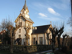 View of the Flosta Church | |
 Aust-Agder within Norway | |
 Flosta within Aust-Agder | |
| Coordinates: 58°31′43″N 08°56′02″E / 58.52861°N 8.93389°ECoordinates: 58°31′43″N 08°56′02″E / 58.52861°N 8.93389°E | |
| Country | Norway |
| County | Aust-Agder |
| District | Østre Agder |
| Established | 1 Jan 1902 |
| Disestablished | 1 Jan 1962 |
| Administrative centre | Kilsund |
| Area | |
| • Total | 22.8 km2 (8.8 sq mi) |
| *Area at municipal dissolution. | |
| Population (1962) | |
| • Total | 1,205 |
| • Density | 53/km2 (140/sq mi) |
| Time zone | UTC+01:00 (CET) |
| • Summer (DST) | UTC+02:00 (CEST) |
| ISO 3166 code | NO-0916 |
| Preceded by | Dypvåg in 1902 |
| Succeeded by | Moland in 1962 |

Flosta (historic: Flougstad) is a former municipality in the old Aust-Agder county in Norway. The 22.8-square-kilometre (8.8 sq mi) municipality existed from 1902 until its dissolution in 1962. It is currently part of the municipality of Arendal in Agder county. The administrative center of Flosta was at Staubø in the village of Kilsund. The municipality primarily encompassed the two islands of Flostaøya and Tverrdalsøya and about 9 square kilometres (3.5 sq mi) on the mainland just north of the islands including the villages of Eikeland, Borås, and Vatnebu.[1][2]
History[]
The municipality of Dybvaag was established on 1 January 1838 (see formannskapsdistrikt law), and this municipality included all of what would later become Flosta municipality. On 1 January 1902, the new municipality of Flosta was established when the islands of Flostaøya and Tverrdalsøya and some of the mainland north of those islands (population: 1,892) separated from the municipality of Dybvaag.
During the 1960s, there were many municipal mergers across Norway due to the work of the Schei Committee. On 1 January 1962, the municipalities of Stokken (population: 2,783), Austre Moland (population: 1,607), and Flosta (population: 1,205) as well as Strengereid area in neighboring Tvedestrand (population: 375) were all merged to create the new municipality of Moland. Later, on 1 January 1992, Moland (including the area of Flosta) was merged into the municipality of Arendal.[3]
Name[]
The name of the municipality (originally the parish and the church) comes from the old name for the island of Flostaøya (Old Norse: Flóstr) since this is where the historic church is located.[4]
Government[]
All municipalities in Norway, including Flosta, are responsible for primary education (through 10th grade), outpatient health services, senior citizen services, unemployment and other social services, zoning, economic development, and municipal roads. The municipality was governed by a municipal council of elected representatives, which in turn elected a mayor.[5]
Municipal council[]
The municipal council (Herredsstyre) of Flosta was made up of 13 representatives that were elected to four year terms. The party breakdown of the final municipal council was as follows:
| Party Name (in Norwegian) | Number of representatives | |
|---|---|---|
| Labour Party (Arbeiderpartiet) | 5 | |
| Conservative Party (Høyre) | 4 | |
| Liberal Party (Venstre) | 4 | |
| Total number of members: | 13 | |
| Party Name (in Norwegian) | Number of representatives | |
|---|---|---|
| Labour Party (Arbeiderpartiet) | 5 | |
| Conservative Party (Høyre) | 4 | |
| Liberal Party (Venstre) | 4 | |
| Total number of members: | 13 | |
| Party Name (in Norwegian) | Number of representatives | |
|---|---|---|
| Labour Party (Arbeiderpartiet) | 4 | |
| Liberal Party (Venstre) | 4 | |
| List of workers, fishermen, and small farmholders (Arbeidere, fiskere, småbrukere liste) | 4 | |
| Total number of members: | 12 | |
| Party Name (in Norwegian) | Number of representatives | |
|---|---|---|
| Labour Party (Arbeiderpartiet) | 3 | |
| Joint List(s) of Non-Socialist Parties (Borgerlige Felleslister) | 9 | |
| Total number of members: | 12 | |
| Party Name (in Norwegian) | Number of representatives | |
|---|---|---|
| Labour Party (Arbeiderpartiet) | 5 | |
| Local List(s) (Lokale lister) | 7 | |
| Total number of members: | 12 | |
| Party Name (in Norwegian) | Number of representatives | |
|---|---|---|
| Labour Party (Arbeiderpartiet) | 2 | |
| Joint List(s) of Non-Socialist Parties (Borgerlige Felleslister) | 2 | |
| Local List(s) (Lokale lister) | 8 | |
| Total number of members: | 12 | |
See also[]
References[]
- ^ a b Kiær, Anders Nicolai; Helland, Amund; Vibe, Johan; Strøm, Boye (1904). "Flosta herred". Norges land og folk: Nedenes amt (in Norwegian). Norway: H. Aschehoug & Company. p. 168. Retrieved 28 November 2017.
- ^ Thorsnæs, Geir, ed. (3 August 2017). "Flosta". Store norske leksikon (in Norwegian). Kunnskapsforlaget. Retrieved 28 November 2017.
- ^ Jukvam, Dag (1999). "Historisk oversikt over endringer i kommune- og fylkesinndelingen" (PDF) (in Norwegian). Statistisk sentralbyrå.
- ^ Rygh, Oluf (1905). Norske gaardnavne: Nedenes amt (in Norwegian) (8 ed.). Kristiania, Norge: W. C. Fabritius & sønners bogtrikkeri. p. 32.
- ^ Hansen, Tore, ed. (12 May 2016). "kommunestyre". Store norske leksikon (in Norwegian). Kunnskapsforlaget. Retrieved 21 December 2020.
- ^ "Kommunevalgene og Ordførervalgene 1959" (PDF) (in Norwegian). Oslo: Statistisk sentralbyrå. 1960. Retrieved 21 December 2020.
- ^ "Kommunevalgene og Ordførervalgene 1955" (PDF) (in Norwegian). Oslo: Statistisk sentralbyrå. 1957. Retrieved 21 December 2020.
- ^ "Kommunevalgene og Ordførervalgene 1951" (PDF) (in Norwegian). Oslo: Statistisk sentralbyrå. 1952. Retrieved 21 December 2020.
- ^ "Kommunevalgene og Ordførervalgene 1947" (PDF) (in Norwegian). Oslo: Statistisk sentralbyrå. 1948. Retrieved 21 December 2020.
- ^ "Kommunevalgene og Ordførervalgene 1945" (PDF) (in Norwegian). Oslo: Statistisk sentralbyrå. 1947. Retrieved 21 December 2020.
- ^ "Kommunevalgene og Ordførervalgene 1937" (PDF) (in Norwegian). Oslo: Statistisk sentralbyrå. 1938. Retrieved 21 December 2020.
External links[]
 Arendal travel guide from Wikivoyage
| |||
 | Towns and cities |
|  |
| Municipalities | |||
- Arendal
- Former municipalities of Norway
- 1902 establishments in Norway
- 1962 disestablishments in Norway