Tromøy
Tromøy kommune
Tromø herred (historic) | |
|---|---|
 View of Tromøy | |
 Aust-Agder within Norway | |
| Nickname(s): The pearl of Southern Norway | |
 Tromøy within Aust-Agder | |
| Coordinates: 58°26′59″N 08°51′51″E / 58.44972°N 8.86417°ECoordinates: 58°26′59″N 08°51′51″E / 58.44972°N 8.86417°E | |
| Country | Norway |
| County | Aust-Agder |
| District | Østre Agder |
| Established | 1 May 1878 |
| Disestablished | 1 Jan 1992 |
| Administrative centre | Brekka |
| Area | |
| • Total | 30 km2 (10 sq mi) |
| *Area at municipal dissolution. | |
| Population (1992) | |
| • Total | 4,711 |
| • Density | 160/km2 (410/sq mi) |
| Time zone | UTC+01:00 (CET) |
| • Summer (DST) | UTC+02:00 (CEST) |
| ISO 3166 code | NO-0921 |
| Preceded by | Østre Moland in 1878 |
| Succeeded by | Arendal in 1992 |


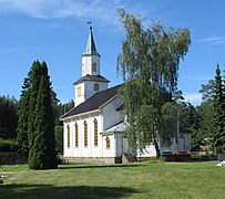
Tromøy (historic: Tromø) is a former municipality in the old Aust-Agder county in Norway. The 30-square-kilometre (12 sq mi) municipality existed from 1878 until its dissolution in 1992. The municipal area is now part of the municipality of Arendal in Agder county. The administrative centre was the village of Brekka, where the historic Tromøy Church is located. The municipality encompassed all of the island of Tromøya as well as many smaller surrounding islands such as Merdø, Gjesøya, Skilsøy, and Tromlingene.[1]
The municipality had two churches: the centuries-old Tromøy Church and the relatively new Færvik Church. Some of the main villages in Tromøy were Færvik, Brekka, Brattekleiv, Sandnes, Revesand, and Pusnes. The municipality was connected to the mainland by the Tromøy Bridge, the only road connection to Tromøya. The other islands of Tromøy were only accessible by boat.
History[]
The municipality of Tromøy was established on 1 May 1878 when the municipality of Østre Moland was divided into three municipalities: Tromøy (population: 2,320), Barbu (population: 4,874), and Østre Moland (population: 2,524). On 1 January 1992 there was a major municipal merger where the following municipalities were merged into the municipality of Arendal: Tromøy (population: 4,711), Moland (population: 8,148), Øyestad (population: 8,679), Hisøy (population: 4,026), and the town of Arendal (population: 12,478).[2]
Name[]
The municipality (originally the parish) was named after its island Tromøya. Historically it was spelled Tromø, but more recently it has been spelled Tromøy. The name comes from the Old Norse Þruma, which means "rim", "edge", or "border". The suffix -ø or øy means "island".[3]
Coat of arms[]
The coat of arms was granted on 23 August 1985 and in use until the municipal merger on 1 January 1992. The blue and white arms represent the sea and the coastline near the village of Brekka, which is characterised by large rounded boulders protruding out into the sea. This landscape dates back to the Ice Age and was used to model the division line in the coat of arms.[4]
Government[]
All municipalities in Norway, including Tromøy, are responsible for primary education (through 10th grade), outpatient health services, senior citizen services, unemployment and other social services, zoning, economic development, and municipal roads. The municipality was governed by a municipal council of elected representatives, which in turn elected a mayor.[5]
Municipal council[]
The municipal council (Kommunestyre) of Tromøy was made up of 21 representatives that were elected to four year terms. The party breakdown of the final municipal council was as follows:
| Party Name (in Norwegian) | Number of representatives | |
|---|---|---|
| Labour Party (Arbeiderpartiet) | 10 | |
| Conservative Party (Høyre) | 6 | |
| Christian Democratic Party (Kristelig Folkeparti) | 2 | |
| Socialist Left Party (Sosialistisk Venstreparti) | 1 | |
| Liberal Party (Venstre) | 2 | |
| Total number of members: | 21 | |
| Party Name (in Norwegian) | Number of representatives | |
|---|---|---|
| Labour Party (Arbeiderpartiet) | 8 | |
| Progress Party (Fremskrittspartiet) | 1 | |
| Conservative Party (Høyre) | 7 | |
| Christian Democratic Party (Kristelig Folkeparti) | 3 | |
| Socialist Left Party (Sosialistisk Venstreparti) | 1 | |
| Liberal Party (Venstre) | 1 | |
| Total number of members: | 21 | |
| Party Name (in Norwegian) | Number of representatives | |
|---|---|---|
| Labour Party (Arbeiderpartiet) | 7 | |
| Conservative Party (Høyre) | 8 | |
| Christian Democratic Party (Kristelig Folkeparti) | 3 | |
| Centre Party (Senterpartiet) | 1 | |
| Liberal Party (Venstre) | 2 | |
| Total number of members: | 21 | |
| Party Name (in Norwegian) | Number of representatives | |
|---|---|---|
| Labour Party (Arbeiderpartiet) | 5 | |
| Conservative Party (Høyre) | 5 | |
| Christian Democratic Party (Kristelig Folkeparti) | 3 | |
| Joint list of the New People's Party (Nye Folkepartiet), Centre Party (Senterpartiet), and Liberal Party (Venstre) | 4 | |
| Total number of members: | 17 | |
| Party Name (in Norwegian) | Number of representatives | |
|---|---|---|
| Labour Party (Arbeiderpartiet) | 7 | |
| Conservative Party (Høyre) | 4 | |
| Christian Democratic Party (Kristelig Folkeparti) | 3 | |
| Liberal Party (Venstre) | 3 | |
| Total number of members: | 17 | |
| Party Name (in Norwegian) | Number of representatives | |
|---|---|---|
| Labour Party (Arbeiderpartiet) | 7 | |
| Conservative Party (Høyre) | 4 | |
| Christian Democratic Party (Kristelig Folkeparti) | 3 | |
| Liberal Party (Venstre) | 3 | |
| Total number of members: | 17 | |
| Party Name (in Norwegian) | Number of representatives | |
|---|---|---|
| Labour Party (Arbeiderpartiet) | 8 | |
| Conservative Party (Høyre) | 4 | |
| Christian Democratic Party (Kristelig Folkeparti) | 2 | |
| Liberal Party (Venstre) | 3 | |
| Total number of members: | 17 | |
| Party Name (in Norwegian) | Number of representatives | |
|---|---|---|
| Labour Party (Arbeiderpartiet) | 9 | |
| Conservative Party (Høyre) | 4 | |
| Liberal Party (Venstre) | 4 | |
| Total number of members: | 17 | |
| Party Name (in Norwegian) | Number of representatives | |
|---|---|---|
| Labour Party (Arbeiderpartiet) | 8 | |
| Conservative Party (Høyre) | 5 | |
| Liberal Party (Venstre) | 4 | |
| Total number of members: | 17 | |
| Party Name (in Norwegian) | Number of representatives | |
|---|---|---|
| Labour Party (Arbeiderpartiet) | 7 | |
| Conservative Party (Høyre) | 4 | |
| Liberal Party (Venstre) | 5 | |
| Total number of members: | 16 | |
| Party Name (in Norwegian) | Number of representatives | |
|---|---|---|
| Labour Party (Arbeiderpartiet) | 6 | |
| Conservative Party (Høyre) | 5 | |
| Liberal Party (Venstre) | 5 | |
| Total number of members: | 16 | |
| Party Name (in Norwegian) | Number of representatives | |
|---|---|---|
| Labour Party (Arbeiderpartiet) | 8 | |
| Conservative Party (Høyre) | 5 | |
| Joint list of the Liberal Party (Venstre) and the Radical People's Party (Radikale Folkepartiet) | 3 | |
| Total number of members: | 16 | |
| Party Name (in Norwegian) | Number of representatives | |
|---|---|---|
| Labour Party (Arbeiderpartiet) | 6 | |
| Conservative Party (Høyre) | 8 | |
| Liberal Party (Venstre) | 2 | |
| Total number of members: | 16 | |
Media gallery[]

Coat-of-arms of Tromøy municipality

Spornes headland on Tromøya

Lighthouse

Hove Forest
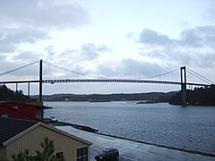
Tromøy bridge


See also[]
References[]
- ^ a b Thorsnæs, Geir, ed. (24 June 2015). "Tromøy – kommune". Store norske leksikon (in Norwegian). Kunnskapsforlaget. Retrieved 26 November 2017.
- ^ Jukvam, Dag (1999). "Historisk oversikt over endringer i kommune- og fylkesinndelingen" (PDF) (in Norwegian). Statistisk sentralbyrå.
- ^ Rygh, Oluf (1905). Norske gaardnavne: Nedenes amt (in Norwegian) (8 ed.). Kristiania, Norge: W. C. Fabritius & sønners bogtrikkeri. p. 97.
- ^ "Civic heraldry of Norway - Norske Kommunevåpen". Heraldry of the World. Retrieved 26 November 2017.
- ^ Hansen, Tore, ed. (12 May 2016). "kommunestyre". Store norske leksikon (in Norwegian). Kunnskapsforlaget. Retrieved 21 December 2020.
- ^ "Kommunestyrevalget 1987" (PDF) (in Norwegian). Oslo-Kongsvinger: Statistisk sentralbyrå. 1988. Retrieved 21 December 2020.
- ^ "Kommunestyrevalget 1983" (PDF) (in Norwegian). Oslo-Kongsvinger: Statistisk sentralbyrå. 1984. Retrieved 21 December 2020.
- ^ "Kommunestyrevalget 1979" (PDF) (in Norwegian). Oslo: Statistisk sentralbyrå. 1979. Retrieved 21 December 2020.
- ^ "Kommunevalgene 1975" (PDF) (in Norwegian). Oslo: Statistisk sentralbyrå. 1977. Retrieved 21 December 2020.
- ^ "Kommunevalgene 1972" (PDF) (in Norwegian). Oslo: Statistisk sentralbyrå. 1973. Retrieved 21 December 2020.
- ^ "Kommunevalgene 1967" (PDF) (in Norwegian). Oslo: Statistisk sentralbyrå. 1967. Retrieved 21 December 2020.
- ^ "Kommunevalgene 1963" (PDF) (in Norwegian). Oslo: Statistisk sentralbyrå. 1964. Retrieved 21 December 2020.
- ^ "Kommunevalgene og Ordførervalgene 1959" (PDF) (in Norwegian). Oslo: Statistisk sentralbyrå. 1960. Retrieved 21 December 2020.
- ^ "Kommunevalgene og Ordførervalgene 1955" (PDF) (in Norwegian). Oslo: Statistisk sentralbyrå. 1957. Retrieved 21 December 2020.
- ^ "Kommunevalgene og Ordførervalgene 1951" (PDF) (in Norwegian). Oslo: Statistisk sentralbyrå. 1952. Retrieved 21 December 2020.
- ^ "Kommunevalgene og Ordførervalgene 1947" (PDF) (in Norwegian). Oslo: Statistisk sentralbyrå. 1948. Retrieved 21 December 2020.
- ^ "Kommunevalgene og Ordførervalgene 1945" (PDF) (in Norwegian). Oslo: Statistisk sentralbyrå. 1947. Retrieved 21 December 2020.
- ^ "Kommunevalgene og Ordførervalgene 1937" (PDF) (in Norwegian). Oslo: Statistisk sentralbyrå. 1938. Retrieved 21 December 2020.
External links[]
 Arendal travel guide from Wikivoyage
| |||
 | Towns and cities |
|  |
| Municipalities | |||
- Arendal
- Populated places established in 1878
- Populated places disestablished in 1992
- Former municipalities of Norway
- 1878 establishments in Norway
- 1992 disestablishments in Norway