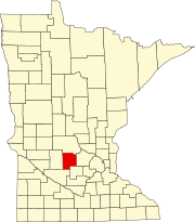
Forest Prairie Township, Meeker County, Minnesota
Forest Prairie Township, Minnesota | |
|---|---|
 Forest Prairie Township, Minnesota Location within the state of Minnesota | |
| Coordinates: 45°17′N 94°27′W / 45.283°N 94.450°WCoordinates: 45°17′N 94°27′W / 45.283°N 94.450°W | |
| Country | United States |
| State | Minnesota |
| County | Meeker |
| Area | |
| • Total | 35.4 sq mi (91.7 km2) |
| • Land | 34.3 sq mi (88.8 km2) |
| • Water | 1.1 sq mi (2.9 km2) |
| Elevation | 1,138 ft (347 m) |
| Population (2000) | |
| • Total | 869 |
| • Density | 25.3/sq mi (9.8/km2) |
| Time zone | UTC-6 (Central (CST)) |
| • Summer (DST) | UTC-5 (CDT) |
| FIPS code | 27-21842[1] |
| GNIS feature ID | 0664196[2] |
Forest Prairie Township is a township in Meeker County, Minnesota, United States. The population was 869 at the 2000 census.
History[]
Forest Prairie Township was given that name for the forests and prairies within its borders. It is just north of Forest City, south of Watkins, and by Clear Lake. It was first settled in the spring of 1866 by Merritt Birdsall Case, Charles T. Groot, J. S. Reynolds, George Scrivner, George Smith, James W. Polk, Seymour Stevens, and Michael A. Roach. The township was organized on June 10, 1867. The first postmaster was H. M. Storrs in 1867.
Merritt Birdsall Case was born on March 15, 1834, and he enlisted on May 17, 1861, in the 1st Minnesota Volunteer Infantry Regiment under . In a skirmish with the rebel soldiers at the Battle of First Bull Run, Virginia, McKune, while rallying his troops for a charge, was shot in the chest and killed. Merritt Case was injured receiving a “gunshot wound of right heel. The ball cut a portion of the heel and lodged under the ankle joint where it now remains and has ever since disabled him from performing manual labor.” Merritt was discharged on December 22, 1863, but he re-enlisted on January 22, 1864, as a lieutenant in the leading a group of African-American soldiers. They were the first of the Colored Troops to be engaged in battle. Merritt was captured by Confederate soldiers on July 30, 1864, at the Battle of the Crater in Petersburg, Virginia, (which was depicted in the 2003 film, Cold Mountain.) Merritt was confined at , in South Carolina. At the war's end, he was freed, and he was discharged from the service on December 29, 1865. Merritt Case died on May 6, 1928.
Geography[]
According to the United States Census Bureau, the township has a total area of 35.4 square miles (92 km2), of which 34.3 square miles (89 km2) is land and 1.1 square miles (2.8 km2) (3.14%) is water.
Forest Prairie Township is located in Township 121 North of the Arkansas Base Line and Range 30 West of the 5th Principal Meridian.
Demographics[]
As of the census[1] of 2000, there were 869 people, 300 households, and 249 families residing in the township. The population density was 25.3 people per square mile (9.8/km2). There were 361 housing units at an average density of 10.5/sq mi (4.1/km2). The racial makeup of the township was 99.42% White, 0.12% African American, and 0.46% from two or more races.
There were 300 households, out of which 39.0% had children under the age of 18 living with them, 77.0% were married couples living together, 3.0% had a female householder with no husband present, and 17.0% were non-families. 13.3% of all households were made up of individuals, and 5.0% had someone living alone who was 65 years of age or older. The average household size was 2.90 and the average family size was 3.19.
In the township, the population was spread out, with 28.9% under the age of 18, 6.1% from 18 to 24, 27.3% from 25 to 44, 28.5% from 45 to 64, and 9.2% who were 65 years of age or older. The median age was 37 years. For every 100 females, there were 109.4 males. For every 100 females age 18 and over, there were 113.8 males.
The median income for a household in the township was $46,375, and the median income for a family was $49,444. Males had a median income of $32,788 versus $22,083 for females. The per capita income for the township was $17,340. About 5.2% of families and 7.6% of the population were below the poverty line, including 10.6% of those under age 18 and 4.1% of those age 65 or over.
References[]
- ^ a b "U.S. Census website". United States Census Bureau. Retrieved 2008-01-31.
- ^ "US Board on Geographic Names". United States Geological Survey. 2007-10-25. Retrieved 2008-01-31.
- Townships in Meeker County, Minnesota
- Townships in Minnesota
- Populated places established in 1867
- 1867 establishments in Minnesota


